
 Yahoo News
 Active severe weather season continues in central US with more storms into the weekend

Yet another busy period of severe thunderstorms is on tap for the nation's midsection into this weekend, warn AccuWeather meteorologists. Storms packing gigantic hail, destructive winds and even a few tornadoes are among the threats faced across more than a dozen states in the coming days.
Multiple weather systems will provide the catalyst for the threat of feisty thunderstorms: a cold front rolling through the Midwest and toward the East Coast through Friday and multiple storms emerging from the Rockies and passing across the Plains into the weekend.
 |
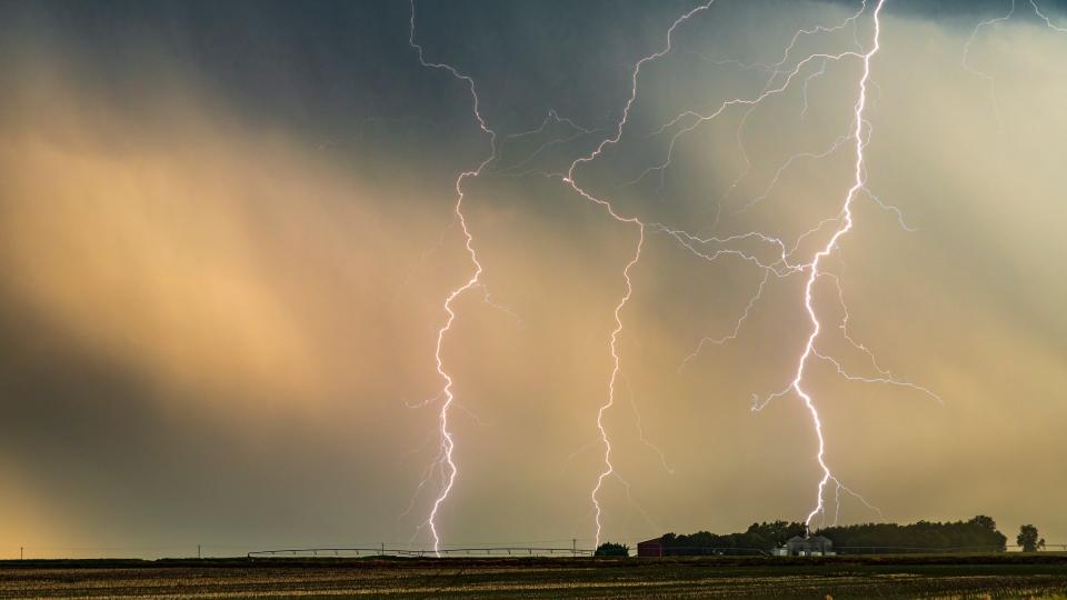
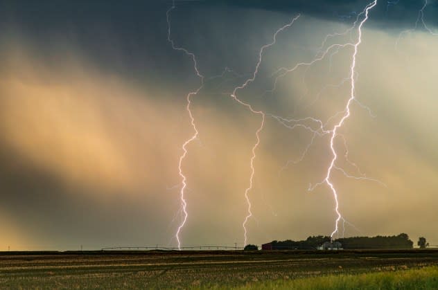
Multiple lightning strikes under a supercell thunderstorm at a ranch farm in Nebraska, USA. (Photo credit: John Finney Photography/Getty Images) |
Even beyond the weekend, the threat of severe weather will persist, but it will shift as a heat dome builds into the Central states, likely bringing the hottest air of the season thus far. Long-duration thunderstorms packing damaging winds will be possible on the northern periphery of that dome, closer to the Canadian border, next week.
A front marking the dividing line between warm and humid air and cooler, more pleasant air behind it will be responsible for the severe weather threat to end the week.
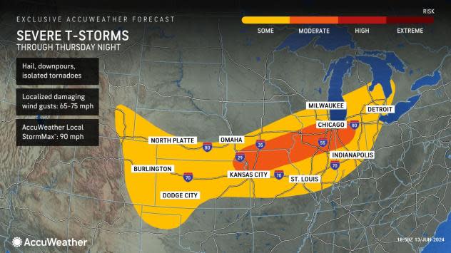
Into Thursday night, cities such as Indianapolis, Kansas City and Omaha can experience thunderstorms packing wind gusts in excess of 65 mph, hail and torrential downpours. Such storms can cause delays or cancellations at major airports and travel hubs such as Chicago, Detroit and St. Louis.
 |
An area from northeastern Kansas to northern Indiana is at particular risk for these nasty storms. Because of that, AccuWeather meteorologists have painted a "moderate" risk for severe thunderstorms in that region. It is not out of the question that a tornado or two can be spawned by the strongest storms within this zone.
By Friday, the risk of severe weather in association with the front will largely shift toward the mid-Atlantic and Northeast, but a few stronger storms can linger across the upper Ohio Valley during the afternoon and evening.
There will be little rest for the storm-weary in the middle of the country, even as the initial cold front departs later this week. At least two storms moving in from the West will spark more gusty thunderstorms from Friday through the weekend.
Residents in the region are probably wondering why the severe weather risk has been seemingly never-ending since late April, and AccuWeather Senior Meteorologist Joe Bauer has the answer.
"This pattern is set up by blocking high pressure in the Northeast and an active storm track moving through the West," explained Bauer. "The longer the blocking high remains over the Northeast, the more prolonged the severe weather risk can extend in the Plains."
This bottlenecked weather pattern will promote additional rounds of severe weather in the nation beginning at the end of the workweek from the Front Range of the Rockies into the central Plains states.
 |
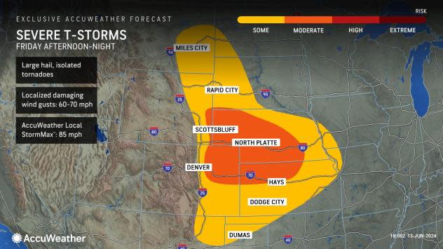
"The first round of storms will come Friday from the Front Range to the High Plains, when they can pack large hail, isolated tornadoes and damaging wind gusts," said Bauer. "Those with outdoor plans around the Denver area may want to consider shifting their plans to the weekend where the chances of thunderstorms are lower."
Ground stops may be issued at Denver airports if thunderstorms come close. Motorists should also be prepared to have delays on Interstates 25, 70 and 80.
 |
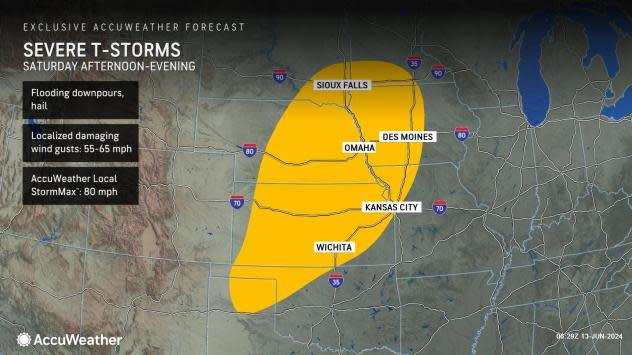
While chances of thunderstorms will lower in the Front Range by Saturday, they will increase in separate areas farther north and east. The same storm will bring at least some risk for severe weather from the northern Texas Panhandle to southern Minnesota, where thunderstorm wind gusts as high as the AccuWeather Local StormMax™ of 80 mph will be possible.
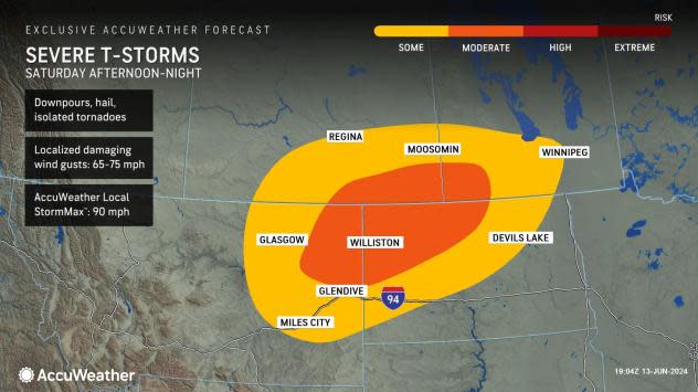
In the meantime, a new storm emerging from the Canadian Rockies on Saturday has AccuWeather warning of a moderate risk for severe weather in parts of Montana, North Dakota and the Canadian Prairies later in the day and at night.
 |
While the tornado threat in this risk area is low, it is not zero amid the strongest of storms. It is important that people who have outdoor activities scheduled should keep an eye to the sky and be prepared to seek shelter indoors.
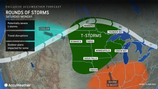
The threat of severe weather will not end with the weekend. Additional storm systems expected to move into the Central states will prolong the risk of damaging storms into next week, but their location is expected to shift north.
 |
Bauer, who is also a member of AccuWeather's long-range forecasting team, is expecting another storm to bring windy conditions from the Front Range to the Plains between Monday and Wednesday. It can also renew the risk of dangerous thunderstorms.
"This storm can draw heat and moisture up into the northern and central Plains, which will elevate severe weather concerns in the region," said Bauer.
Following that, AccuWeather's long-range forecasters are also expecting the same heat dome that will torch the Eastern U.S. with the hottest weather so far this summer to build into the Plains later next week. This would act to shift the storm track farther north, allowing potentially severe thunderstorms to move through in several rounds from the northern U.S. and southern Canada east into the Great Lakes region.
Additional reporting by AccuWeather meteorology intern Peyton Simmers.
Want next-level safety, ad-free? Unlock advanced, hyperlocal severe weather alerts when you subscribe to Premium+ on the AccuWeather app. AccuWeather Alerts™ are prompted by our expert meteorologists who monitor and analyze dangerous weather risks 24/7 to keep you and your family safer.