
 Yahoo News
 Airborne laser scans find Mayan ‘megalopolis’ under the jungle in Guatemala

Airborne laser scans have uncovered a vast Mayan ’megalopolis’ with tens of thousands of buildings including pyramids under the jungle in Guatemala.
The remains include canals and industrial-sized fields, and suggest that millions of people may have lived in the area.
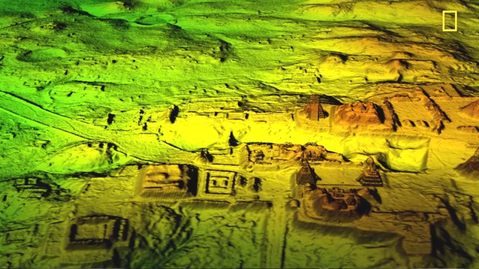
The remains lay hidden for centuries, but were detected using airborne light detection and ranging technology, or LiDAR.
New images released yesterday have now given even greater insight into the civilisation itself.
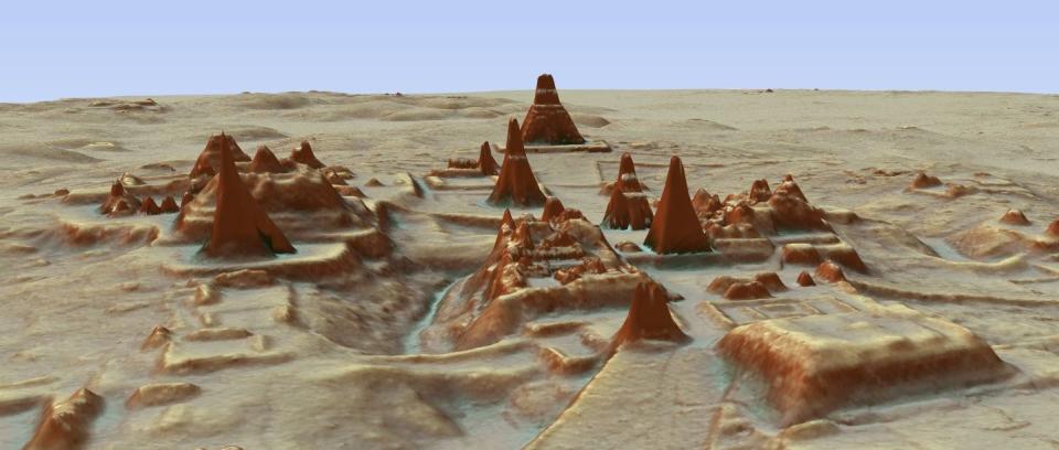

The find suggests that the area may have been home to more than 10 million people, and that at its peak 1,500 years ago, the Mayan civilisation was more advanced than Chinese or Greek cultures.
Huge defensive walls and fortresses uncovered in the area also suggest a long history of war.
MOST POPULAR ON YAHOO UK TODAY
James Bulger killer Jon Venables jailed again for possesion of 1,000 indecent child images
Young woman, 28, shares heartbreaking photos of final days after shock cancer diagnosis
The internet is obsessed with a clip of how Donald Trump’s hair actually works
Coleen Nolan reveals she’s divorcing husband of 10 years after ‘hellish’ 12 months
Welsh teen, 17, sent home from A&E after constipation complaint is found dead 24 hours later
Two London neighbours are locked in a passive aggressive parking war
Stephen Houston, Professor of Archaeology and Anthropology at Brown University said, ‘’I think this is one of the greatest advances in over 150 years of Maya archaeology.
‘I know it sounds hyperbolic but when I saw the [Lidar] imagery, it did bring tears to my eyes.’
Portions of the ruins had already been documented by archaeologists, but previous explorations had found only pieces of the puzzle.
‘Archaeologists were working on the ground in the summers, kilometer by kilometer,’ said NCALM Director Ramesh Shrestha.

‘If the work had continued in the classical archaeological method, they would not have finished in their lifetimes.
‘Little by little, we are putting together a picture of how the Americas were populated before the arrival of the Europeans, before Columbus,’ said Juan Fernandez-Diaz, senior researcher with the center.
For the Guatemala project, the LiDAR information was gathered over the course of eight days and 44 hours of flight and involved 38 billion laser pulses.
The plane was equipped with a state-of-the-art multispectral Titan MW LiDAR sensor, based on specifications requested by NCALM and developed by Teledyne Optech.
Airborne LiDAR is a remote sensing technology used to produce high resolution three-dimensional maps using lasers.
It works by firing hundreds of thousands of laser pulses per second from an aircraft flying at a relatively low altitude; a timing device measures the round-trip travel time, using that information to create detailed topographical maps.

