
 Yahoo News
 Azores blast brings scorching 38C to UK amidst European heatwave
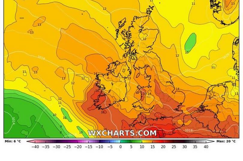
The damp and drizzly start to July in the UK is set to change as Europe's intense heatwave begins to affect the British Isles. This is according to the latest weather maps from WXCHARTS, which show countries like Spain and Greece, currently experiencing temperatures of 40C and above, sharing their heat.
The maps focus on July 21, when the mercury is expected to rise again.
Many Brits have been worried about the lack of typical summer weather, especially with the peak of the meteorological summer approaching next week, signalling the gradual transition towards autumn and winter.
Since mid-June, temperatures have generally been cooler than average, with the Met Office issuing only one heat-health alert this year when temperatures hit 30C.
However, Jim Dale, senior meteorologist for British Weather Services, predicts a rise to around 25C in approximately 11 days, although he admits that GFS weather models are currently "all over the shop", reports the Express.
Speaking to Express.co.uk, he said: "The weather models are all over the shop at the moment. Seemingly it will be much warmer from the 21st, between 24-25C, tops, but struggling to reach 30C. I can't trust them beyond there but the expectation is of pleasant weather in the main."
When asked why this summer has remained relatively cool compared to our European neighbours who are enduring extreme heats of more than 40C, Mr Dale provided a straightforward response.
He remarked: "We are on the edge of all things, the Northerly quarter airstream. You might say we are lucky not to be in the oven with them."
Netweather forecasters have also shared insights into the weather for the next 10 days leading up to GFS and Mr Dale's anticipated heat spike on July 21. Nick Finnis commented: "Unfortunately it's not looking too promising for the next 7-10 days if it's heat you're after, with most model ensemble guidance suggesting a continuation of cool conditions for the time of year, with the jet stream to the south of the UK."
However, he did hint at a potential bright spot with the influence of an Azores high possibly affecting the south of England.
Between July 15 and 24, the Met Office has indicated some signs of a more settled period but remains non-committal, stating: "There are limited, if any, signs for more prolonged settled and warm weather, but winds are likely to stay fairly light overall with temperatures, particularly across the south, coming up to around the average for the of year."
Looking further ahead to August 8, there are sporadic indications of varied weather patterns. The Met Office adds: "There remain encouraging signs of a more settled spell developing at some point during the period, at least for a time, and perhaps more likely in the south."
"However, by the same token further, perhaps shorter, unsettled interludes are likely too, and confidence in the broad weather patterns during this period is much lower than average. Above average temperatures overall, and drier than average conditions overall, are slightly favoured."
