
 Yahoo News
 Coldest start to winter in decades for eastern Australia with power grid under strain
Eastern Australia’s giant cold snap is finally breaking down but not before temperatures reached lows not seen for seven decades or longer and pushed the country’s main electricity grid to the brink.
The extended chill was caused by an unusual weather pattern that locked in cool pools of air over southern and eastern states, triggering the deepest snow dumps in the alps since 1968, according to Ben Domensino, a senior meteorologist at Weatherzone.
“Because it was so persistent over two weeks, we haven’t seen a start to winter that cold in decades for most of south-eastern Australia,” Domensino said.
“In this last two to three-week period, we’ve just seen relentless south-westerly winds” making temperatures feel even more frigid, and prompting people to rug up and turn thermostats higher, he said.
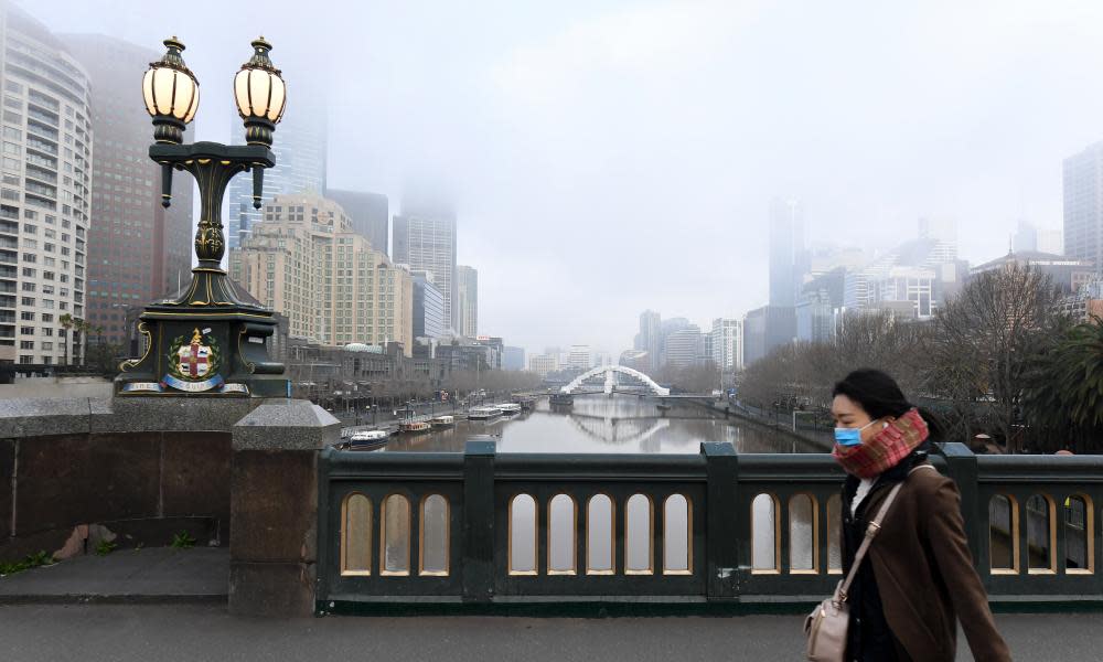
Melbourne was among the colder cities. The Victorian capital’s main monitoring site failed to breach 15 degrees during the period for the first time since 1949, Domensino said.
Canberra, well known for its frosty winters, remained below 12.7 degrees, its coldest start to winter since 1964. Hobart, the state capital most exposed to bracing Antarctic cold fronts, remained below 13.8 degrees for its coolest winter’s start since 1982.
Related: Chris Bowen warns energy generators against market manipulation amid crisis
Australia’s energy market regulators and generators keep a close eye on the weather as a guide to consumption with the highest increases in power demand typically prompted by summer heatwaves.
The challenge is that the accuracy of weather models tends to decline beyond about seven days out, making it difficult to anticipate lengthy spells of heat or cold and the resulting heavier demand for electricity and gas.
“Even at the end of May, there’s no way we could have known that this whole first fortnight of June was going to be this cold,” Domensino said.
The prolonged drain on energy generators has come at a time when many coal-fired power stations were already at reduced capacity because of scheduled or forced maintenance. Soaring wholesale power prices and mounting forecasts of power supply gaps in eastern states spurred regulators to suspend the national electricity market on Wednesday indefinitely.
The geographic spread of the cold weather was another factor in the demand strain since many population centres experienced the unusually brisk conditions.
Adelaide, although on the fringe of the worst of the cold, had its coolest start to winter in 15 years, while for Sydney it was the coldest in about 16 years. The Bureau of Meteorology’s main site at Observatory Hill has been partly offline this month.
Brisbane, not typically equipped for chilly conditions, had its coldest start to winter since 1990, including three days when temperatures stayed below 18 degrees.
Inland regions, such as Dubbo, were also on the cold side. The central NSW city did not reach 14.5 degrees during the fortnight for the first time since 1921.
Related: Can anything really be done about the ‘perfect storm’ in Australia’s energy markets?
Taking a slightly longer view, Melbourne’s run of 17 days below 15 degrees from 30 May was the longest so early in the season in 109 years, according to Weatherzone.
The forecasts of 15 degrees or more for the city from Thursday for most of the coming week are among the signs the cold spell is breaking – at least temporarily, Domensino said.
“We’ve already moved out of that weather pattern,” he said. “We’re back to more normal temperatures for this time of year.”
The cold weather saw the “southern annular mode” switch to the negative phase that results in westerly wind patterns shifting north from Antarctica. That shift combined with long-wave troughs that caused pools of cool air to linger by chance over south-eastern states. Drier conditions also took hold.
Negative SAM (for the first time in ages) and a declining La Nina = dry start to June for many areas
SAM: https://t.co/sFu8TrI55S
Map: https://t.co/IK5qtDamWH pic.twitter.com/pQu4kvoZLW— Andrew B. Watkins (@windjunky) June 16, 2022
But more cool conditions are on the way, with a weak cold front expected to move through South Australia, Victoria, Tasmania and parts of southern NSW early next week. A bigger challenge for energy suppliers may come later next week when a second front sweeps eastwards, potentially causing bigger and more widespread drops in temperatures, Domensino said.
Those hoping to make the most of the cold by visiting alpine skifields have cause for cheer, with Spencer Creek in the Snowy Mountains recording its deepest snow since 1968, according to SnowyHydro data.
The snow depth in the Australian Alps is at highest for this early in the season since 1968. (Spoiler alert, though, conditions have turned slushier in many places as conditions warm up.) (Source: SnowyHydro, Weatherzone's @Ben_Domensino ) pic.twitter.com/8TESQZygyF
— Peter Hannam (@p_hannam) June 16, 2022
“We had a really good two weeks of snow but now we’re back to this warmer weather,” Domensino said. “So there’s a risk that we might see some rain washing some of that snow away in the coming weeks.”
“It is always a very fine line between rain and snow at any time of year [for the alps] but especially in June,” he said. “The peak of the snow season is usually in late August.”

