
 Yahoo News
 Land Vanishes Under Monsoon Floods in New Satellite Image
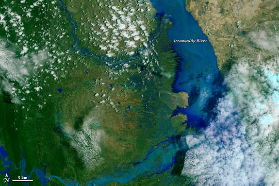

A river in Myanmar appears swollen with monsoon rain in a new photo taken from space.
The overflowing Irrawaddy River — the longest river in the country — is emblematic of the worst floods to hit the Southeast Asian nation in decades. The torrential rains have displaced thousands of people and caused over 70 deaths, according to local coverage in The Star Online.
In May, just a few months prior to the floods, Myanmar farmers faced hot, arid weather that threatened to destroy their crops, as it did last year. Aerial images of the same spot on the river from two years ago, in August 2013, show a much thinner line of water that weaves between little islands. But now, intense monsoon rains have submerged the little islands and are damaging crops in the region. [Fishy Rain to Fire Whirlwinds: The World's Weirdest Weather]
Although flooding is not unusual in Myanmar, the current flood is bigger than any seen in the last several decades, according to NASA. Cyclone Komen, a tropical storm that made landfall on July 30 and spun through the country, likely boosted the ferocity of the floods, NASA officials said.
The rains have caused many rivers throughout Myanmar to overflow, including the Irrawaddy River, which extends more than 1,300 miles (2,000 kilometers).
The aerial views of the Irrawaddy River, captured by the Landsat 8 satellite, are composites of natural- and false-color images. Land areas maintain natural colors, and look brown and green in the satellite photos. Areas covered by water are highlighted with false color to look bright blue, according to NASA.
Without the added blue colors, the floodwaters would be difficult to distinguish from land, since water picks up loose brownish sediments, agency officials added.
Floods and other natural disasters are expected to become more common as the Earth warms, according to the International Disaster Database.Texas and Oklahoma felt the effects of devastating floods linked to El Niño in May, and floods are more frequent now in the central United States, according to a study published in February in the journal Nature Climate Change.
Elizabeth Goldbaum is on Twitter. Follow Live Science @livescience, Facebook & Google+. Original article on Live Science
Copyright 2015 LiveScience, a Purch company. All rights reserved. This material may not be published, broadcast, rewritten or redistributed.
