
 Yahoo News
 Category 5 atmospheric river takes aim at Northern California with series of strong storms
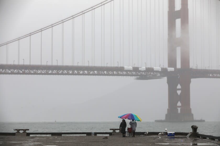
Several strong storms are rushing toward Central and Northern California, bringing much-needed rain to drought-stricken areas beginning Thursday night, but also raising fears of flooding in fresh fire scars.
A large trough of low pressure hovering off the coast of the Pacific Northwest is driving repeated rounds of precipitation in the northern part of California and ushering in the first major storm of the season, National Weather Service forecasters said.
What's known as an "atmospheric river" will pump continuous moisture over the region, said Ryan Kittell, a meteorologist with the weather service's Oxnard station, and experts say it will be a doozy.
The atmospheric river forecast for this weekend is a category 5 — the highest level on a scale based on strength and duration, according to Marty Ralph, director of the Center for Western Weather and Water Extremes at Scripps Institution of Oceanography, a department of UC San Diego. Ralph is the leader of the team that developed the rating system.
On Thursday morning, scattered showers were reported across Central and Northern California, with more storms moving in. A storm system arriving in the evening and lasting into Friday is expected to be "significant," said Emily Heller, with the weather service's Sacramento station.
The northern Sierra Nevada had already received about 10 inches of snow by the beginning of the week, and 1 to 2 feet more might be dumped in the region early next week, Heller said.
Weather officials said the Sacramento area and north could receive a half-inch to 2 inches of rain, with the majority falling along and north of Interstate 80. Mountain areas might get up to 4 inches. About half an inch could fall over San Francisco, and the northern coastal areas, including portions of Sonoma and Trinity counties, could see 1 to 2 inches of rain.
Another storm, which Heller called the "really heavy hitter," is slated to roll in Sunday night and will be even stronger.
Up to 4 inches of rain is forecast to fall over the Sacramento and San Francisco areas from Saturday night through Tuesday, with most precipitation on Sunday and Monday, forecasters said. By the time skies clear next week, mountain regions could see up to 10 inches.
While the bulk of the rain will be to the north, the storm system will also drift into Southern California. Weather officials predict metro areas in Los Angeles County could get about a half-inch of rain, and 1 to 1 1/2 inches in the mountains.
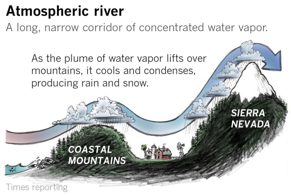
Ralph described an atmospheric river as "essentially a river in the sky," adding, "but it's a river of water vapor rather than liquid."
The weather systems are typically 1,000 to 2,000 miles long and hundreds of miles wide, and there's generally three to four of them in the Northern Hemisphere at any given time. The average atmospheric river carries about 25 times more water than the Mississippi River, Ralph said.
Ralph and his team developed a scale for atmospheric rivers similar to what's used to gauge the intensity of hurricanes, tornadoes and other strong winds. It's intended to separate storms that are beneficial — those that feed the water supply — from those that are potentially hazardous.
The atmospheric river coming ashore in Northern California this weekend has been deemed a 5 — or "exceptional," which is as strong as they get — because it exceeds a threshold of water vapor transport and will last more than 48 hours, Ralph said.
"It's quite unusual this time of year" to see an atmospheric river of this force, he said. His team researched 40 years' worth of storms in the Bay Area and discovered only one atmospheric river was recorded in October during that time. An atmospheric river of this magnitude in the area occurred once every four years on average over those 40 years, Ralph said.
"Normally, the way it works is we just have this band of moisture move down the coast. And that's the kind we're going to see in Southern California," Kittell said. "But up there, they actually have it where it stalls." The storm system could hover for days over the central part of the state, potentially dropping copious amounts of rain.
And the moisture arrives not a moment too soon. California just recorded its driest water year in a century. Average precipitation for the state's 2021 water year was about half of what experts consider typical.
Earlier this week, Gov. Gavin Newsom declared a statewide drought emergency, imploring Californians to conserve water in the face of one of the state’s most severe droughts on record.
There are cautious hopes that the coming rains will bring relief and reduce fire risk in the state's parched regions, but they're not expected to end the drought.
"Unfortunately, two years of drought — one storm is not going to fix it," Heller said. Sacramento typically records 12.63 inches of rain per water year. Last year, it was closer to 7 inches.
The rain could be beneficial but it also brings risks. Mountains and other landscapes charred by ferocious wildfires are vulnerable to debris flows if heavy rain falls in a short period of time.
The National Weather service issued flood watches from Thursday afternoon and evening through Friday morning for northern burn scars, including this year's nearly 1-million acre Dixie fire, as well as the North Complex, Zogg and CZU Lightning Complex fires of 2020.
There are fears that the influx of heavy rain "could bring potential ash and debris flows over recent burn scar areas in Shasta, Tehama, Butte and Plumas counties," the weather service said in an advisory. Threatened areas include Greenville and Highway 70, along with the cities of Quincy, Chester and Paradise.
Steep terrain in the Santa Cruz Mountains, where the CZU Lightning Complex raged last year, is prone to debris flows, and weather officials are monitoring that area, according to meteorologist Jeff Lorber of the weather service's Monterey station. Fires create a water-resistant ground layer, leading to runoff that carries sediment and debris, he said.
Portions of Northern California and Oregon are parched from the drought, and there's a chance the landscape will, "like a dry sponge, soak up a pretty good chunk of the rainfall from the storm," Ralph said. But precipitation already falling to the north could moisten the soil and decrease absorption.
"So it remains to be seen how much [rain from] the big storm on Sunday is going to soak up into the soils versus go into the rivers," he added.
Concerns are lower in Southern California, where comparatively less rain is expected and some burn scars are older, and therefore less prone to slides and flooding, weather officials said.
But officials are "moderately concerned" about the area charred by the recent Alisal fire in western Santa Barbara County, which ignited Oct. 11.
"It's really fresh," Kittell said. "There's a few vulnerable areas that any kind of mud and debris flows would cause some issues."
As little as 0.7 inch of rain could trigger a debris flow, and weather officials said they anticipate a "nuisance variety" flood advisory event, said Eric Boldt, a warning coordination meteorologist with the weather service.
Gusty winds between 40 and 50 mph are also expected in some Southern California mountain and desert regions, beginning Friday. Northwest winds are expected in the Santa Barbara mountains and along the 5 Freeway corridor Friday and Saturday nights. On Sunday night through Monday, southwest winds could course through deserts and higher elevation areas, including the Antelope Valley.
High surf and dangerous rip currents were observed along Central Coast waters Thursday, and weather officials expect the hazardous conditions to last through Tuesday night. Large swells and bigger surf could force the closure of Morro Bay and Ventura Harbors entrances on Monday and Tuesday, officials warned.
This story originally appeared in Los Angeles Times.

