
 Yahoo News
 Strong winds and low temperatures expected this weekend as Storm Hannah hits
Weather forecasters have warned of gusts of up to 80mph (130km/h) and low temperatures “more like January” this weekend, with Storm Hannah expected to hit Ireland and the UK.
The low-pressure weather system, which was named by Met Eireann on Thursday, is expected to bring strong winds to Ireland and southern parts of the UK from Friday afternoon to Saturday morning.
Status Orange – Wind warning for Clare, Cork, Kerry and Limerick
Valid: Friday 26 April 2019 16:00 to Saturday 27 April 2019 05:00 pic.twitter.com/kxklPySnY8
— Met Éireann (@MetEireann) April 25, 2019
The Irish weather service has issued a status orange advisory for Clare, Cork, Kerry and Limerick, warning of the weather “becoming stormy on Friday evening and overnight as Storm Hannah moves in”, bringing gusts of 110-130km/h.
The warning is due to start at 4pm on Friday and expire at 5am on Saturday.
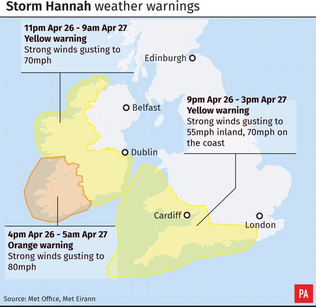
Meanwhile, the Met Office has moved to issue a yellow warning for winds in southern Wales, as well parts of the south and south-west of England, warning of gusts up to 70mph on coasts.
The warning is due to last from 9pm on Friday until 3pm on Saturday, with forecasters predicting “a risk of disruption to travel”.
It is predicted that Hannah – the fourth named storm in the UK and Ireland in 2019 after Erik, Freya and Gareth – will lead to a much cooler Saturday, in contrast to the hot and sunny bank holiday weekend.

Highs of 25C were recorded at Heathrow and Northolt in London on what was the warmest Easter Monday on record in the UK and Ireland, but highs of just 13C are expected in the same areas on Saturday.
Speaking about the low temperatures, Alex Deakin, a Met Office meteorologist, told the Press Association: “It will be such a shock when you compare it to last Saturday. Some places could be 15C lower than last Saturday. It’s incredible, really.
“Some places through Saturday may be struggling in the single figures, while last Saturday we were in the mid 20s.
“It’s going to be a much colder feel, and that’s temperatures on the thermometer – when you add on the strength of the wind on Saturday, it’s going to feel more like January at times, especially compared to last weekend when it felt like summer.”
The strongest winds on Friday night into Saturday will be around exposed coasts of south Wales and southwest England where gusts could reach 70 mph – stay #Weathaware #StormHannah pic.twitter.com/VPktZ7JQxz
— Met Office (@metoffice) April 25, 2019
But Mr Deakin said that Sunday looks like a “half-decent day” weather-wise, saying: “It’s particularly good news for people doing the London Marathon, because if it were on Saturday it would be a wash out, whereas Sunday looks a lot better.”
Meanwhile, Met Eireen forecasters are predicting “very disturbed and unsettled” weather conditions, with the potential for stormy conditions in the south west of Ireland on Friday.
The meteorological service warned: “With many trees now in leaf, this system has the potential to result in trees down, leading to power outages and dangerous driving conditions.”
On Thursday, a status yellow wind warning was issued for Connacht, Carlow, Kildare, Kilkenny, Laois, Longford, Wexford, Wicklow, Offaly, Donegal, Tipperary and Waterford, running from 11pm on Friday to 9am on Saturday.
But a Met Office spokesman said that by the “close of play” on Saturday evening the centre of the low pressure system would have moved on to the Netherlands, meaning the windy and stormy conditions will ease.
