
 Yahoo News
 Typhoon Mawar – latest: Thousands evacuated as cyclone ‘Betty’ passes over Philippines island
Over 4,800 people have been evacuated, schools and offices were shut and flights halted in the Philippines as typhoon Mawar passes over the country's eastern waters.
Mawar, now known as Betty locally, is expected to move “generally northwestward” as it affects the Batanes islands and coastal parts of Luzon island, the country's most populated province.
While the typhoon is not making direct landfall in the Philippines, it is expected to bring up to 4 inches of rain to some regions as authorities issue warnings for landslides, thunderstorms and flooding.
The cyclone, the strongest so far of 2023, has weakened from its status as a "super typhoon" last week but is "still maintaining strength" while moving slowly over parts of the Philippines, the state weather agency said.
Typhoon Mawar was last spotted 315km east of Basco in Batanes, the northernmost islands of the Philippines.
Weather advisories have also been issued by Taiwan and Japan as the typhoon is set to exit the Philippines in next two days.
Last week, Mawar wreaked havoc on the US territory of Guam, with harsh winds and heavy rains bringing flooding, widespread damage to property and power cuts.
Key points
Thousands evacuated, schools shut and flights halted in Philippines
Typhoon Mawar 'maintaining strength' as it passes over Batanes islands
Mawar to 'steadily weaken' over next five days
Mawar can ‘remain stagnant’ east of Taiwan for ‘days’
Typhoon Mawar lashes Taiwan
09:00 , Stuti Mishra
Typhoon Mawar lashed Taiwan's eastern coast with wind, rain and large waves on Tuesday, but largely skirted the island.
With waves crashing on the shoreline, residents of Taiwanese fishing town Yilan secured boats and homes against the stormy conditions.
"I will not worry. The typhoon won't make landfall now. The typhoon will move northward from the sea in the east of Taiwan," Wang Jian-chi, a fishing boat owner told AP.
"Its strength has also weakened. And there is no wind and waves in the fishing port at present. I don't think it will affect us," he said.
The coastguard said precautions were being taken just in case.
"We have issued a high surf warning. The wind and wave are very strong. We hope that beachgoers won't come near the beach and embankment at this moment. We will also send coast guard personnel to patrol the port to warn beachgoers," said coast guard officer Wang Hsing-chieh as he patrolled the port with his team.

Government building collapses in Cagayan Island
07:45 , Stuti Mishra
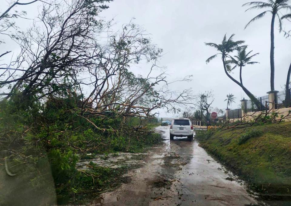
Heavy rains and winds damaged a government building in the Cagayan region of the Philippines yesterday as typhoon Mawar brings extreme weather to the northern region of the archipelago.
The paper milling building of the Cagayan Economic Zone Authority, situated in Santa Ana, Cagayan, collapsed under heavy winds, reported Rappler quoting the region’s provincial office.
Santa Ana is under alert for heavy gusts of wind from typhoon Mawar, locally known as Betty.
The paper milling building of the Cagayan Economic Zone Authority in Santa Ana, Cagayan, collapsed on Monday afternoon, May 29. Santa Ana is under Signal No. 2 due to Typhoon Betty (Mawar). #BettyPH 📸: Cagayan Police Provincial Office https://t.co/217luraKWY pic.twitter.com/pUvyyNaDKB
— Rappler (@rapplerdotcom) May 30, 2023
What parts of Philippines are affected by typhoon Mawar
06:47 , Stuti Mishra
Typhoon Mawar, locally referred to as 'typhoon Betty', is at its closest point to the Philippines today before it is projected to start moving away from the country's island chains tomorrow.
The typhoon, the strongest of 2023 so far and which has already battered Guam, is affecting the northern parts of the archipelago with heavy rains and gusts of wind.
Maps from the Philippines Atmospheric, Geophysical and Astronomical Services Administration (PAGASA) show the northern province of Luzon, the country's most populated region, is taking a hit from the worsening weather.
The most impacted areas include the Batanes Islands and the northeastern portion of Cagayan Valley, including the Babuyan Islands.
PAGASA has issued warnings for landslides, flooding and thunderstorms as up to 4 inches of rains is expected with at least 62kmh and up to 88kmh gusts of winds expected in next 24 hours.
Some damage to buildings has been report in coastal regions of Cagayan on Monday.
Typhoon Mawar 'maintaining strength' as it passes over Batanes islands
06:07 , Stuti Mishra
Typhoon Mawar, now known as Betty locally, continued its northwestward trek overnight as it passes over the Batanes islands and coastal parts of Luzon, the country's most populated province.
The Philippines has evacuated thousands, issued tidal wave warnings and halted flights as worsening weather impacts the country's northern parts with some damages reported overnight.
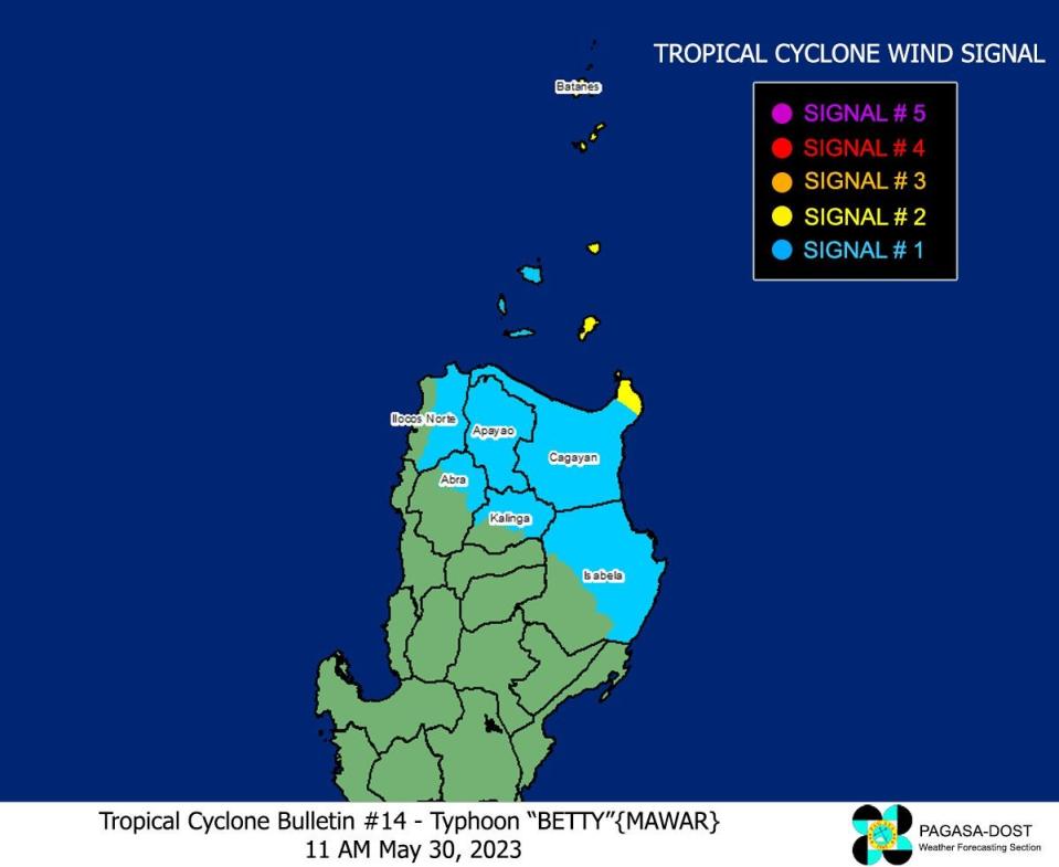
TROPICAL CYCLONE BULLETIN NO. 14
Typhoon #BettyPH (MAWAR)
Issued at 11:00 AM, 30 May 2023
Valid for broadcast until the next bulletin at 5:00 PM today.
TYPHOON #BettyPH MAINTAINS ITS STRENGTH AND IS NOW MOVING WEST NORTHWESTWARD OVER THE SEA EAST OF BATANES… pic.twitter.com/FS7iuZlBjn— PAGASA-DOST (@dost_pagasa) May 30, 2023
While the cyclone, the strongest so far of 2023, has weakened from its status as a "super typhoon" last week, it is "still maintaining strength" while moving slowly over parts of the Philippines, the country's weather agency said in its latest update.
Typhoon Mawar was last spotted today morning 315km East of Basco, Batanes, the northern islands of the Philippines.
It was moving at 10kmh towards the northwest with maximum sustained winds of 150 kmh near the centre and gusts of up to 185 kmh.
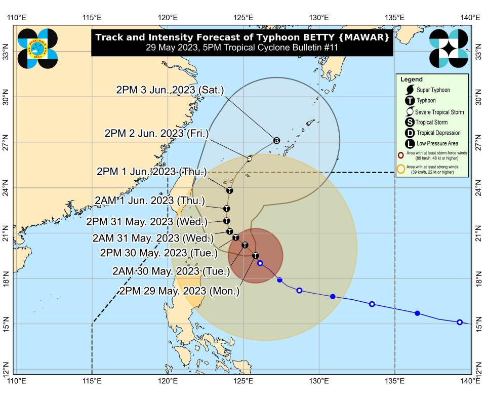
Projected path of typhoon Mawar
04:30 , Stuti Mishra
The image from the Philippine Atmospheric, Geophysical and Astronomical Services Administration (PAGASA) shows the projected path of typhoon Mawar, locally referred to as typhoon Betty.
The typhoon is expected to bring heavy rains in Taiwan and Japan’s Okinawa this week.
New satellite image shows Typhoon Mawar close to Philippines
03:00 , Stuti Mishra
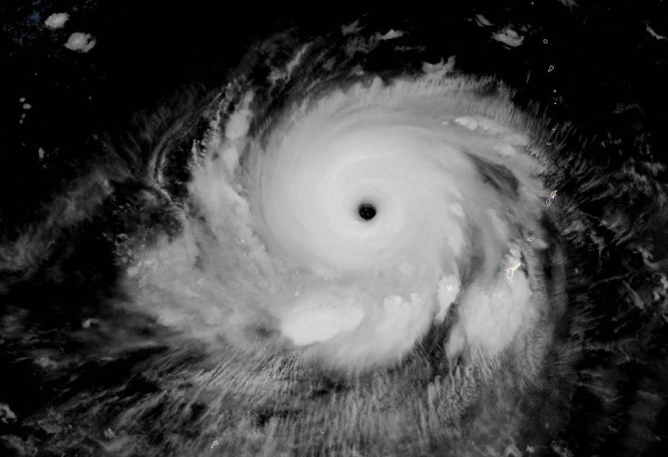
A satellite image released by Nasa shows the typhoon inching close to the Philippines as the country braces for heavy rains and winds.
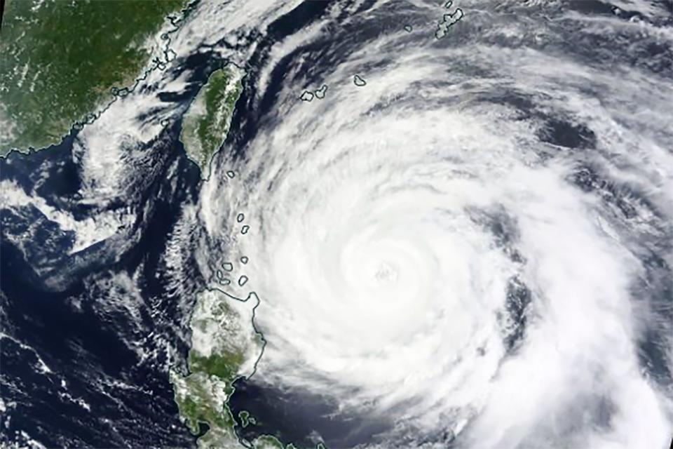
The cyclone is expected to come closer to the southeastern country today in its westward journey. After tomorrow, it is expected to move towards the north away from the Philippines and towards Taiwan and Japan
Mawar can bring heavy rains and violent winds to Okinawa, Japan issues alert
01:30 , Stuti Mishra
Japan’s southern coastal parts can experience rough seas, high tides, violent winds, and torrential rain as Typhoon Mawar approaches its prefecture of Okinawa, the Japan Meteorological Agency (JMA) has said in a new warning.
The typhoon, which is currently on a northward trajectory from the east of the Philippines, is projected to move closer to Taiwan and Japan in the coming days.
The Philippines state weather agency PAGASA forecasts the typhoon to begin to weaken as it moves and encounters colder waters. However, the slow speed of the typhoon is worrying experts with possibilities of the cyclone stagnating in the region for a while, impacting the weather in both Taiwan and Japan.
The powerful typhoon is expected to get closer to the Sakishima Islands, off the main island of Okinawa and 360 km from Taiwan, from Wednesday.
Despite getting weaker in the last couple of days, the typhoon is still packing winds of of 155 kmh near the centre and gusts of up to 190 kmh. It is moving at a speed of around 10 km per hour.
Heavy rain is expected to inundate both eastern and western Japan in the days ahead, as the front will stay for a long period of time, the JMA said.
Wave surges of up to five meters are anticipated on the main island of Okinawa, reaching as high as seven meters near the Sakishima Islands.
The agency has warned people to remain vigilant for landslides and flooding in low-lying areas. Additionally, it said there is a possibility of lightning strikes associated with the typhoon.
‘Reassure your children. It’s going to be a little bit scary as we go later into the night'
Tuesday 30 May 2023 00:00 , Audrey McAvoy
“Reassure your children. It’s going to be a little bit scary as we go later into the night,” Brandon Aydlett said in a Facebook Live update as Guam was in the throes of the typhoon on Wednesday. “You can hear the sounds: The winds are howling, things are breaking. Just be together, talk to each other and things will slow down toward midnight and continuing into Thursday morning.”
Earlier, his brother explained to viewers of another live update that the weather was about to get worse.
“We’re starting to hear the low rumbles in the building here at the National Weather Service,” Landon Aydlett said. “Our doors are rattling. We hear little whistles through the windows, little cracks in the doors. We’re getting those effects here as we’re nearing typhoon force conditions.”
He told The Associated Press in a brief telephone interview Thursday morning local time that working with his brother is like working with his best friend. They never planned to work together, he said.
“But the jobs fell in our laps, and we followed our heart and our passion for the work,” Aydlett said. “And somehow we both ended up in Guam.”
From North Carolina to Guam
Monday 29 May 2023 22:00 , Audrey McAvoy
The brothers are from Elizabeth City, North Carolina, a small farming town in the Outer Banks about an hour south of Norfolk, Virginia. Brandon Aydlett came to Guam first, more than 13 years ago, and his brother arrived a half-year later.
The brothers like to go hiking and paddleboarding. Brandon Aydlett enjoys running. Landon Aydlett — who at Thursday’s final briefing sported a necklace of small white shells gifted to him after a 2018 typhoon — prefers to lift weights. Last year they broke two Guinness world records by building the world’s largest and tallest toy timber tower as part of a Habitat for Humanity fundraiser. The “Tower for Humanity” raised $20,000 for the Guam chapter of the charity.
Landon Aydlett said he’s heard about spouses working together in National Weather Service offices, but never about other twins.
Guam is an island of about 150,000 people about 3,900 miles (6,275 kilometers) west of Hawaii and 1,600 miles (2,600 kilometers) east of Manila, the capital of the Philippines.

‘We are one Guam. We are one Marianas. Stay sheltered and stay safe'
Monday 29 May 2023 20:00 , Audrey McAvoy
The weather service office issues forecasts for Guam as well as several islands to the north — Saipan, Tinian and Rota — that are part of the Commonwealth of the Northern Mariana Islands, another U.S. territory. The Guam office also forecasts weather for the nearby independent Pacific island nations of the Marshall Islands, Micronesia and Palau.
On Thursday, in their final live update as the storm began to subside, they kept passing the informational baton back and forth. It would be their last update from Guam, Landon Aydlett said, after nearly 48 hours together in the forecasting office.
“I don’t know what my house is looking like right now,” he said. “I’ll find out very soon, but we will ride it out together. We are one Guam. We are one Marianas. Stay sheltered and stay safe.”
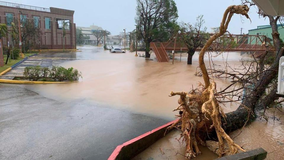
Typhoon Mawar: Satellite images show destruction ravaged by storm in Guam
Monday 29 May 2023 19:00 , Stuti Mishra
Clean up after Mawar could take weeks, officials say
Monday 29 May 2023 18:00 , Stuti Mishra
Officials said it could take weeks to clean up the mess after Mawar briefly made landfall as a Category 4 storm last week on the northern tip of the US Pacific territory of roughly 150,000 people, flipping cars, tearing off roofs and leaving trees bare.
Some villages had little or no water over the weekend, police Sgt Paul Tapao said.
About 51,000 customers were without electricity, according to the Federal Emergency Management Agency. And nearly 1,000 people were still in shelters as of Thursday, Guam officials said.
The central and northern parts of the island received more than 2 feet of rain as the eyewall passed. The island’s international airport flooded, and the swirling typhoon churned up a storm surge and waves that crashed through coastal reefs and swamped houses.
Guam breathes sigh of relief as island weathers super Typhoon Mawar without single deat
Monday 29 May 2023 17:00 , Stuti Mishra
Chainsaws buzzed on Friday as neighbours helped each other clear toppled trees and began cleaning the wreckage of Typhoon Mawar, which walloped Guam as the strongest typhoon to hit the island in over two decades but appeared to have passed without leaving death or massive destruction in its wake.
While it was still early going in the recovery effort, police Sgt Paul Tapao said there did not seem to be any major damage, main arteries were passable and “Guam has been very blessed to have no storm-related deaths or any serious injuries.”
To Mr Tapao, the roar of the mechanical saws was a reminder of the resilience of the storm-prone US Pacific territory and its people.
“Everyone helps out with the cleaning,” he said. “That’s the Guamanian way — that’s embedded in the blood.”
He added that there’s a saying in Chamorro — the indigenous language of the Mariana Islands — “inafa maolek,” that means cooperation, a concept of restoring harmony or order.
Read more:
Guam breathes sigh of relief as Typhoon Mawar leaves without single death
Philippines warns of flooding, landslide as typhoon Mawar inches close
Monday 29 May 2023 16:00 , Stuti Mishra
Philippine officials began evacuating villagers, shut schools and offices and imposed a no-sail ban as Typhoon Mawar approached the country’s northern provinces.
Read more:

Philippines warns of flooding, landslide potential as Typhoon Mawar slowly passes to north
The most powerful typhoons to hit the Philippines
Monday 29 May 2023 15:00 , Stuti Mishra
As typhoon Mawar barrells its way towards the Philippines as a “super typhoon”, the nation braces itself for a week of heavy rains and winds.
After rapidly intensifying to become the most powerful storm of 2023 after battering Guam, typhoon Mawar posed a significant threat with peak winds reaching 215kph and gusts nearing 265kph.
The Philippines is considered the most exposed country in the world to tropical storms as approximately 20 cyclones enter the Philippine Area of Responsibility (PAR), the area of the ocean the country monitors, yearly.
As the country once again prepares for the onslaught of this powerful cyclone, here are some of the strongest storms that have battered the country in recent times.
From Odette to Mawar: The most powerful typhoons to hit the Philippines
ICYMI: Mawar to ‘steadily weaken’ over next five days
Monday 29 May 2023 14:02 , Stuti Mishra
Typhoon Mawar, now known as Betty locally, is forecast to “steadily weaken over the next five days”, according to the latest update from Philippine Atmospheric, Geophysical and Astronomical Services Administration (PAGASA) today.
The storm, which maintained its intensity as a “super typhoon” for over 60 hours last week leaving scientists calling it a “beast”, has now gradually started to weaken as it inches close to the Philippines.
TROPICAL CYCLONE BULLETIN NO. 10
Typhoon #BettyPH (MAWAR)
Issued at 11:00 AM, 29 May 2023
Valid for broadcast until the next bulletin at 5:00 PM today.
TYPHOON #BettyPH SLIGHTLY DECELERATES WHILE MOVING NORTHWESTWARD OVER THE WATERS EAST OF CAGAYAN.https://t.co/iqWDkvVJK6 pic.twitter.com/A6tW9TDS0j— PAGASA-DOST (@dost_pagasa) May 29, 2023
A super typhoon is equivalent to a category 5 hurricane, while the current speed of the cyclone puts it in category 4.
The weather agency expects the cyclone to go further down in intensity as it encounters cooler waters northwards towards the sea of Japan.
Betty may be downgraded into a severe tropical storm late on Thursday or early Friday and into a tropical storm by the end of the week, the agency says.
‘More than 500 FEMA personnel are supporting response and recovery efforts’
Monday 29 May 2023 13:00 , Gustaf Kilander
On Sunday, FEMA said in a press release that “crews continue to work to restore electricity and water service in the affected areas, with more than 65 per cent of Guam’s substations being restored and more than 70 per cent of power restored in areas of Rota of the Northern Mariana Islands (CNMI). Feeding and bottled water operations continue as needed and requested by the territory and the commonwealth officials”.
Federal, territorial, commonwealth and local government personnel, and volunteer organizations continue responding to residents in Guam and CNMI to address key life-safety measures and to address recovery needs. As efforts switch from response to recovery, more personnel are on their way to the region to support emergency officials’ efforts.
More than 500 FEMA personnel are supporting response and recovery efforts in Guam and CNMI, with more than 200 staff in Guam. FEMA is coordinating with its network of Voluntary Organizations Active in Disasters to provide support and humanitarian aid in the areas impacted by Typhoon Mawar.
FEMA on 28 May
Mawar can bring heavy rains and violent winds to Okinawa, Japan issues alert
Monday 29 May 2023 12:30 , Stuti Mishra
Japan's southern coastal parts can experience rough seas, high tides, violent winds, and torrential rain as Typhoon Mawar approaches its prefecture of Okinawa, the Japan Meteorological Agency (JMA) has said in a new warning.
The typhoon, which is currently on a northward trajectory from the east of the Philippines, is projected to move closer to Taiwan and Japan in the coming days.
The Philippines state weather agency PAGASA forecasts the typhoon to begin to weaken as it moves and encounters colder waters. However, the slow speed of the typhoon is worrying experts with possibilities of the cyclone stagnating in the region for a while, impacting the weather in both Taiwan and Japan.
The powerful typhoon is expected to get closer to the Sakishima Islands, off the main island of Okinawa and 360 km from Taiwan, from Wednesday.
Despite getting weaker in the last couple of days, the typhoon is still packing winds of of 155 kmh near the centre and gusts of up to 190 kmh. It is moving at a speed of around 10 km per hour.
Heavy rain is expected to inundate both eastern and western Japan in the days ahead, as the front will stay for a long period of time, the JMA said.
Wave surges of up to five meters are anticipated on the main island of Okinawa, reaching as high as seven meters near the Sakishima Islands.
The agency has warned people to remain vigilant for landslides and flooding in low-lying areas. Additionally, it said there is a possibility of lightning strikes associated with the typhoon.
Schools and offices shut, flights halted and thousands evacuated in Philippines
Monday 29 May 2023 12:00 , Stuti Mishra
Philippine officials have ordered evacuations of thousands of people living in the coastal areas, closed schools and offices, imposed a no-sail ban and dozens of flights are halted as Typhoon Mawar approaches the country's northern provinces.
The typhoon, which recently battered Guam, is projected to spare the mountainous region a direct hit but may still bring dangerous conditions including tidal surges, flash floods, and landslides, the state weather agency has warned.
Mawar will pass the Batanes province tomorrow or on Wednesday as it moves towards the island with a speed of 10kmh.
It currently has maximum sustained winds of 155 kmh near the centre and gusts of up to 190 kmh, considerably down from its intensity last week but still enough to unleash devastating impacts.

"Even if the sun is up, the weather is so unpredictable nowadays and could change anytime so we should always stay on the side of safety," assistant secretary Raffy Alejandro from the office of civil defence told The Associated Press.
"We're talking here of potential threats to lives."
Preparedness measures are in place, with troops, police, and volunteers ready for search and rescue operations. Evacuation efforts have already relocated over 4,800 people, and emergency shelters and food supplies have been prepared for contingencies.
As a typhoon-prone country situated on seismic faults, the Philippines faces numerous natural calamities each year.
"These typhoons, earthquakes and natural calamities have been a part of our lives," Batanes vice governor Ignacio Villa told the AP. "We cannot afford not to prepare because that would potentially mean the loss of lives and major damage."
Mr Villa said the local government lent ropes to villagers living in high-risk communities to strengthen their houses as the typhoon approached.
Typhoon Mawar now moving at 10kmh, PAGASA says in latest advisory
Monday 29 May 2023 11:30 , Stuti Mishra
Typhoon Mawar, known in the Philippines as storm Betty, was last pinpointed 445km east of Calayan island at the northern part of the archipelago, the Philippine Atmospheric, Geophysical and Astronomical Services Administration (PAGASA) said in its 5pm local time update today.
The typhoon is now moving at a reduced speed of 10kmh toward northwest, with its projected path showing the cyclone will pass through the country but not make direct landfall.
It is expected that the typhoon will begin moving away from the Philippines, towards Taiwan and Southern China, in the next two days after inching closer. It is expected to stagnate in the region for a while and continue to lose its intensity by the end of the week.
Why does the Philippines change names of cyclones?
Monday 29 May 2023 10:45 , Stuti Mishra
Typhoon Mawar, which wreaked havoc in Guam last week, is now being called "Betty" since it moved into the oceanic area monitored by the Philippines.
While the name change can be confusing for a lot of people, Mawar isn't the only cyclone to be renamed and known locally with a different name in the Philippines.
The Philippines, in fact, changes the names of all its typhoons once they enter the so-called Philippines Area of Responsibility (PAR), a large area of the Western North Pacific which includes most of the country's land territory, the main island of Palau, most of Taiwan, as well as parts of Malaysia and the Japanese prefecture of Okinawa.
From typhoon Odette, which was previously named typhoon Rai, to the Philippines' deadliest typhoon in modern history, typhoon Yolanda, which was previously called typhoon Haiyan, all these storms went through a change of name after crossing the line in the ocean.
Agencies such as the World Meteorological Organisation (WMO) name cyclones that occur in the Pacific to help in the quick identification of storms in warning messages.
However, since the PAR region is monitored by the Philippine Atmospheric, Geophysical and Astronomical Services Administration (PAGASA), it independently operates its own naming scheme for tropical cyclones that occur within the territory.
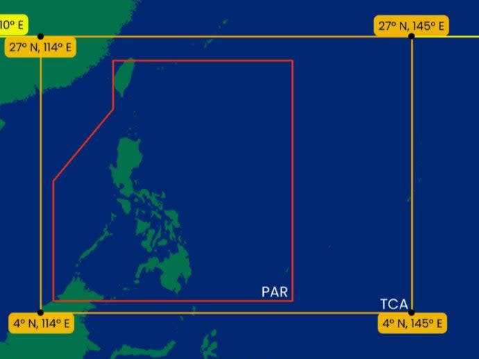
The state weather bureau assigns each Philippine typhoon name alphabetically to determine the number of typhoons that enter PAR every year. The Philippines is one of the most exposed countries in the world to tropical cyclones.
PAGASA also maintains a back-up list if all 25 names are used in a year.
Some of these names are also local Filipino names that help with quick recall of the storms that enter its monitored area.
FEMA provides update on Guam recovery efforts
Monday 29 May 2023 10:00 , Gustaf Kilander
#Mawar Update: Our teams are on the ground assessing damages in all affected areas. We're moving pallets of food & water from our Guam distribution center to supplement territorial supplies at points of distribution & shelters housing survivors.
More: https://t.co/WJlwForIID pic.twitter.com/cHsQ8K8dAU— FEMA (@fema) May 28, 2023
In Photos: Coastal regions evacuated and aid arrives as Philippines prepares for extreme weather
Monday 29 May 2023 09:15 , Stuti Mishra


Preemptive evacuation underway in Philippines
Monday 29 May 2023 08:30 , Stuti Mishra
Over a hundred people have been evacuated from the coastal areas of the Philippines as typhoon Mawar raises alerts for heavy rains and gusts of winds.
The authorities in the northern Cagayan Valley yesterday moved 38 families, or 113 individuals away as a pre-emptive evacuation, reported Rappler.
It comes as the state weather agency issued alerts for landslides, heavy rains and destructive winds for the next few days sparked by typhoon Mawar.
The identical twin weathermen protecting an island from a deadly 140mph typhoon
Monday 29 May 2023 08:00 , Audrey McAvoy
As Typhoon Mawar aimed its fury at Guam, residents facing terrifying winds and crashing waves from the strongest typhoon to hit the US Pacific territory in decades had identical twin meteorologists to keep them informed — and to provide the outside world with a glimpse of the chaos unfolding on the remote island.
The National Weather Service‘s Guam office employs Landon Aydlett as its warning coordination meteorologist. His brother Brandon Aydlett is the science and operations officer.
Together, the 41-year-olds tag-teamed Facebook Live broadcasts watched by thousands as Typhoon Mawar approached with maximum sustained winds of 140 mph (225 kph), wreaking havoc as residents lost power, internet and water service.
Their colorful descriptions of the Category 4 storm painted a picture as they both took turns describing trees snapped like toothpicks, thrashing winds, nearly 2 feet (0.6 meters) of torrential rain and “whiteout conditions” outside the office where they holed up with other colleagues for nearly 48 hours.
Read more:

The identical twin weathermen protecting an island from a 140mph typhoon
New satellite image shows Typhoon Mawar close to Philippines
Monday 29 May 2023 07:30 , Stuti Mishra
A satellite image released by Nasa shows the typhoon inching close to the Philippines as the country braces for heavy rains and winds.
The cyclone is expected to come closer to the southeastern country in the next two days in its westward journey. After that, it is expected to more towards the north away from the Philippines and towards Taiwan and Japan
Luzon expected to be struck by rains, flooding, landslides, and strong winds
Monday 29 May 2023 07:00 , Stuti Mishra
Typhoon Mawar, locally known as Betty, was moving northwest in the direction of the Philippines and Taiwan this morning after it wreaked havoc on the US territory of Guam last week with harsh winds and rain.
On Monday morning, typhoon Mawar was 470km east of the largest and most populous island of the Philippines – Luzon - prompting alerts for heavy rains and wind and some evacuations.
The Philippine weather agency said that northern Luzon was expected to be struck by rains, flooding, landslides, and strong winds.
Some parts of the island nation were also expected to be hit by almost four inches of rain today or tomorrow morning.
“Under these conditions, flooding and rain-induced landslides are likely,” the Philippine Atmospheric, Geophysical and Astronomical Services Administration (PAGASA) said in its 11am local time update today.
The cyclone currently has maximum sustained winds of 155 kmh near the centre and gusts of up to 190 kmh, considerably down from its intensity last week.
Mawar is set to move north and subsequently northeast, with the effects in Taiwan, China, and South Korea likely to be reduced to some heavy rainfall.
Mawar to 'steadily weaken' over next five days
Monday 29 May 2023 06:25 , Stuti Mishra
Typhoon Mawar, now known as Betty locally, is forecast to "steadily weaken over the next five days", according to the latest update from Philippine Atmospheric, Geophysical and Astronomical Services Administration (PAGASA) today.
The storm, which maintained its intensity as a "super typhoon" for over 60 hours last week leaving scientists calling it a "beast", has now gradually started to weaken as it inches close to the Philippines.
A super typhoon is equivalent to a category 5 hurricane, while the current speed of the cyclone puts it in category 4.
The weather agency expects the cyclone to go further down in intensity as it encounters cooler waters northwards towards the sea of Japan.
TROPICAL CYCLONE BULLETIN NO. 10
Typhoon #BettyPH (MAWAR)
Issued at 11:00 AM, 29 May 2023
Valid for broadcast until the next bulletin at 5:00 PM today.
TYPHOON #BettyPH SLIGHTLY DECELERATES WHILE MOVING NORTHWESTWARD OVER THE WATERS EAST OF CAGAYAN.https://t.co/iqWDkvVJK6 pic.twitter.com/A6tW9TDS0j— PAGASA-DOST (@dost_pagasa) May 29, 2023
Betty may be downgraded into a severe tropical storm late on Thursday or early Friday and into a tropical storm by the end of the week, the agency says.
Typhoon Ompong (Mangkhut) 2018
Monday 29 May 2023 06:00 , Stuti Mishra
Super typhoon Mangkhut caused extensive damages in Guam, the Philippines, and South China in September 2018.
It was also the strongest typhoon to affect Hong Kong since Ellen in 1983.
With highest winds of 285kmh, the typhoon made landfall in northern Cagayan valley, leaving a trail of destruction in its wake.
The torrential rainfall triggered landslides and destroyed buildings. Almost all buildings in Tuguegarao, Cagayan‘s provincial capital experienced some sort of damage due to the typhoon.
The storm caused a total of $3.77bn (£3.05bn) in damage across multiple nations, along with at least 134 fatalities reported: 127 in the Philippines, six in mainland China, and one in Taiwan.
Typhoon Glenda (Rammasun) 2014
Monday 29 May 2023 05:00 , Stuti Mishra
The typhoon left 225 people dead and unleashed destructive impacts across the Philippines, South China, and Vietnam in July 2014.
It reached the Philippines after passing directly over Guam with a wind speed of 260kmh and a rainfall volume of 200mm.
This typhoon caused damage amounting to over $771m (£625m). It also left almost 90 per cent of Manila residents without power for days.
Typhoon Pablo (Bopha) 2012
Monday 29 May 2023 04:00 , Stuti Mishra
Another typhoon that caused heavy devastation in the Philippines region was the 2012’s Bopha, or locally named Pablo. It was considered the strongest tropical cyclone to ever hit Mindanao island.
Recording over 280kph of winds, the typhoon made landfall in three separate locations: Northern Mindanao, Central Visayas, and Palawan.
It affected over five million people and left at least 1,900 people dead.
The damages from the cyclone stood at $1.16m (£939m), the third costliest for the southeastern nation.

