
 Yahoo News
 Zealandia: What secrets does the world's hidden eighth continent hold?

A team of scientists will today set sail from Australia on a two-month expedition to discover the secrets of the mysterious, largely submerged continent of Zealandia.
With increasingly detailed seafloor maps available, scientists are now wondering what secrets the lost eighth continent, which is about half the size of Australia, holds.
As the drilling expedition gets underway, here is The Telegraph's guide to the mostly “hidden” landmass.
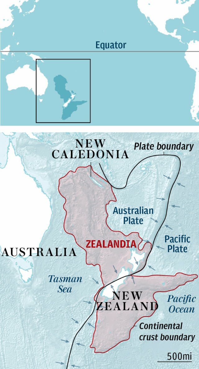
What and where is Zealandia?
Zealandia is the world’s eighth and smallest continent – and the newest to be discovered.
It is located in the southern Pacific Ocean, including New Zealand, New Caledonia and two Australian islands, Lord Howe Island and Norfolk Island.
The continent spans 1.9 million square miles but the bulk of it – 94 per cent – is under the Pacific Ocean. It is about two-thirds the size of Australia.
Who discovered it?
The continent has been gradually discovered by scientists over the past two decades.
In 1995, American geophysicist Bruce Luyendyk used the name to describe New Zealand, the Chatham Rise, Campbell Plateau and Lord Howe Rise.
At that stage, it was believed to possess three of four attributes needed to qualify as a continent, including rock types which are found on continents rather than on the ocean crust and "the high elevation relative to regions floored by oceanic crust”.
Earlier this year, a team of scientists used fresh satellite and mapping data to argue that Zealandia was not a collection of “submerged continental fragments” but was a unified landmass and therefore should be assigned continent status.
They published their findings in a study titled "Zealandia: Earth's Hidden Continent" in the journal of the Geological Society of America. Their views have been widely accepted.

How did Zealandia form?
The underwater section of Zealandia is believed to have detached from the continent of Australia and sank 60 to 85 million years ago.
In places off the coast of the Australian state of Queensland, the two continents are only fifteen miles apart. Its crust is relatively thin and ranges in thickness from six to 24 miles.
What is happening on the expedition?
Thirty scientists from the International Ocean Discovery Program (IODP) are setting out from Australia aboard a large drilling ship to drill into the seafloor to try to understand the history and structure of Zealandia.
The team of international scientists will drill about 1,000 to 2,600 feet into the seafloor at six sites in the Tasman Sea to collect sediment samples – containing fossil evidence - deposited over millions of years.
The aim is to examine tectonic plate shifts which occurred around 50 million years ago, when Australia and New Zealand stopped spreading apart and instead the area between them began to compress.
“We’re really looking at the best place in the world to understand how plate subduction initiates,” according to expedition co-chief scientist Gerald Dickens, professor of Earth, environmental and planetary science at Rice University in Texas.
“This expedition will answer a lot of lingering questions about Zealandia.”
.@QC_News prof embarks on expedition to learn more about the world's eighth continent #CUNY#Zealandia : https://t.co/HaSrvpvxeBpic.twitter.com/aR5MG7c7CR
— CUNY Admissions (@CUNYWC) July 24, 2017
What does the expedition hope to learn?
The sediment samples will help scientists to understand the history of Zealandia and the cause of the tectonic plate shifts which led to New Zealand and a volcano chain being lifted above the waterline as the Pacific Plate dived downwards some 50 million years ago.
The scientists will also examine ocean and climate patterns to try to understand the relationship between climate change and tectonic shifts.
The initial expedition will run from July 27 to September 26.

