
 Yahoo News
 2nd round of flooding rain, high winds in 4 days to hammer Northeast


The same storm that evolved into a dangerous and travel-shuttering blizzard over the Midwest into this weekend will throw flooding rain and damaging winds at the Northeast, AccuWeather meteorologists continue to warn. This will be the second time within four days that dangerous and disruptive conditions slam the region.
The new storm brought a second round of heavy rain and severe thunderstorms to parts of the southern United States this week into Friday. Incidents in the South have been limited compared to the storm from earlier this week. However, as the storm intensifies, dramatic and dangerous conditions will ramp up in the Northeastern states into this weekend.
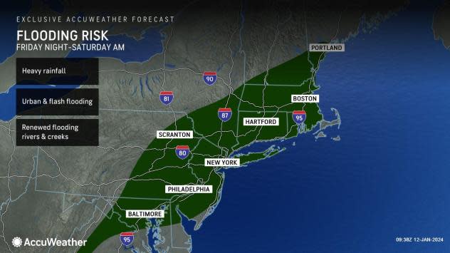
The storm will unleash another 1-2 inches of rain on the Eastern states into Saturday, with local amounts of up to 3 inches.
"Even though this rain is roughly about half of what the storm dumped on the region earlier this week, it will not take as much to renew flooding problems and to match or exceed the severity of flooding," AccuWeather Senior Meteorologist Courtney Travis said.
 |
Streams are running high, some rivers are still out of their banks and the soil remains saturated from parts of the Southeast to New England. In some cases early this week, small streams and rivers reached record high levels for January, typically a time for low water levels.
Much of the rain from the storm and cold front will fall in less than eight hours, meaning that the general 1-2 inches of rain will fall at an excessive rate. Small streams and poor drainage areas along streets, highways and subway stations will rapidly fill with water.
Travel conditions in the Northeast will range from difficult, due to pouring rain and a wintry mix for a time over the interior, to dangerous, where torrential downpours lead to flash flooding.
The heaviest rain from Georgia to Delaware already fell during the first part of Friday night. However, the heaviest rain has since pivoted into southern New England as of Saturday morning.
Rapidly rising streams and flooded roadways can still add to the danger to motorists during any Saturday morning travel.
Forecasters urge motorists never to drive through flooded areas as the road surface may have been washed away and the water may be deep enough to submerge the vehicle.
 |
Due to the prior rainstorm, many of the rivers may be cresting or will have crested as the new round of heavy rain begins. However, as runoff from the new rainstorm surge works its way downstream into progressively larger streams, new crests are likely on many of the major rivers in the region later this weekend to early next week, well after the storm departs.
In some cases, rising water levels may surpass that of the storm from earlier in the week. This means that moderate to major river flooding may be more widespread.
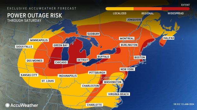
The new storm may have even stronger, farther-reaching and longer-lasting high winds compared to the previous storm. This, combined with the fact that the soil has been so wet for so long, means that tree and property damage and the scope of power outages may be more widespread and severe this time around.
 |
Some areas in the Appalachians and along the Eastern Seaboard will be hit with high winds from two directions.
The first round will have brief but powerful south and southeast winds into early Saturday. These winds will push ocean water onto the barrier islands and up into the bays, where moderate coastal flooding can occur from the Carolinas to Maine.
 |
The second round of high winds will kick in fast but may be much longer-duration blusters from the west and northwest Saturday afternoon to Saturday night. Winds hitting the topsy-turvy trees from different directions in short order could take a toll.
Wind gusts of 40-60 mph from the storm will reach nearly every state from the Mississippi River to the Atlantic and Gulf coasts. Localized stronger gusts ranging from 60-80 mph are likely in the Appalachians and along the mid-Atlantic and New England coasts, where an AccuWeather Local StormMax™ gust of 90 mph is possible.
A 'seiche' is possible on Lake Erie, where high winds will slosh water levels up seven feet at Buffalo and down ten feet at Toledo, Ohio.
 |
There is the potential for hundreds of thousands of people to be without power in the eastern half of the nation due to the size and strength of the new storm. As of Saturday morning, power outages reported by poweroutage.us have already reached over 360,000. In heavily wooded areas, power outages could be lengthy due to the size of debris. This could put some people at risk as temperatures plunge in the wake of the new storm, due to the arrival of Arctic air for the first time this winter.
Forecasters recommend that people make sure that they have flashlights and batteries on hand. Generators should be fueled and tested. Experts advise always using generators outdoors, away from windows, to reduce the risk of fumes getting inside.
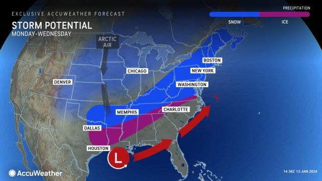
"As the leading edge of Arctic air arrives, there is the potential for snow squalls to progress from the central Appalachians to the mid-Atlantic coast from later Saturday night to Sunday morning," AccuWeather Director of Forecasting Operations Dan DePodwin said.
In the past, snow squalls have contributed to rapidly changing weather conditions and multiple vehicle pileups on area interstate highways.
 |
AccuWeather meteorologists continue to monitor the potential for a significant winter storm along the Atlantic coast from Monday night to Wednesday. This new storm threat could end the accumulating snow drought in the I-95 mid-Atlantic region.
Want next-level safety, ad-free? Unlock advanced, hyperlocal severe weather alerts when you subscribe to Premium+ on the AccuWeather app. AccuWeather Alerts™ are prompted by our expert meteorologists who monitor and ana
