
 Yahoo News
 April nor'easter to unload feet of snow in northern New England, New York


 |
A powerful and long-lasting April nor'easter could end up being one of the biggest snowstorms of the winter for portions of northern New England and northern New York, AccuWeather meteorologists warn. The storm will also bring significant long-lasting impacts to much of the Great Lakes and Northeast in terms of wind and cold air.
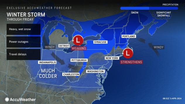
The same large and complex storm poised to trigger severe weather into the middle of the week will stall, re-organize and generate much colder air from the Great Lakes to the Northeast.
Rain that drenched areas from the Ohio Valley to the central Appalachians and mid-Atlantic coast into Monday was only a prelude to the main part of the storm. More rain will pour down in some areas into midweek and end up triggering flash flooding in urban areas as well as small stream flooding and significant rises on some of the rivers in the region.
 |
As one part of the storm from the Midwest weakens, a new storm will develop along the coast. Instead of this storm continuing to head out to sea, it will creep slowly northward along the New England coast during the middle and latter parts of this week.
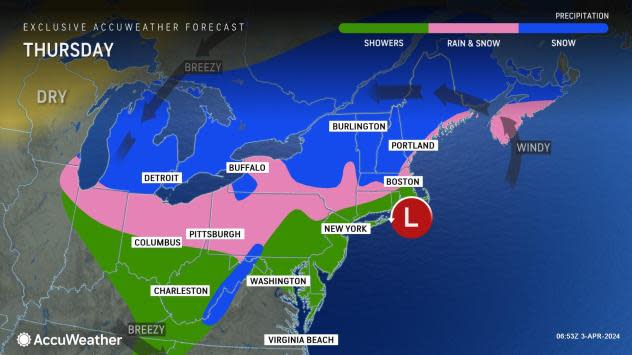
As the storm strengthens, it will gather strong winds and more moisture from the Atlantic. The latest indications are it will be too warm for snow to fall in New York City, along the southern coast of New England and along much of the eastern coast of Massachusetts.
It will be a different story just a bit farther to the north and west. Rain will either transition to heavy wet snow, or wet snow will commence farther northwest where the air is cold enough in much of Maine, New Hampshire, Vermont, northern New York state and the hilly ground in central and western Massachusetts.
 |
Snowfall rates may exceed 2 inches per hour at times, which will more than compensate for warm road surface temperatures, leading to a considerable amount of slush and snow buildup.
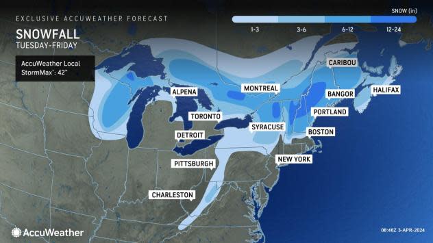
The storm has the potential to produce snowfall exceeding that from a storm a little over a week ago that dropped 1-2 feet of snow from Vermont to northern Maine. The storm this week, because of its extended duration, could bring general snowfall of 2 feet with an AccuWeather Local StormMax™ of 42 inches.
This storm will have worse impacts than the storm from mid-March, AccuWeather Senior Meteorologist and New England native Joe Lundberg said.
"The storm this week will bring down trees and power lines over a widespread area," Lundberg explained.
The combination of wet, clinging snow in the northern part of the storm, with the emergence of some buds on the trees and high winds within and outside of the snow area, will likely trigger the damage. Some neighborhoods may be without power for days as streets and secondary roads may be clogged with heavy, wet snow as well as fallen trees and limbs.
 |
Snow will extend farther west and south during the storm, with bands of snow occurring as far to the west as parts of Wisconsin, northern Illinois and northern Indiana. Some accumulating snow will extend into the higher elevations of Pennsylvania, western Maryland and West Virginia, as well as the hills in western Connecticut.
Periods of rain will soak Boston and New York City through Thursday. A slushy coating to an inch or so of snow is in store for Boston itself, but mainly on non-paved surfaces, with little or no accumulation near Boston Logan International Airport. However, only a couple dozen miles to the northwest of Boston, heavy snow is likely to fall. Less than 75 miles north of New York City, heavy snow may be found in part of the Hudson Valley.
A mixture of rain and wet snow will occur at times in Detroit from Wednesday to Thursday. Around Chicago, a mix of rain and wet snow will continue, leaving a coating of an inch or two, mainly on non-paved surfaces north and west of the city by Wednesday morning.
 |
A large pocket of heavier snow will ramp up into Wednesday over Wisconsin and northern Michigan. A general 6-12 inches will fall on central and northeastern Wisconsin, with a pocket where 1-2 feet of snow will pile up on Michigan's Upper Peninsula.
"Persistent, strong northeast winds during the storm in central and northern New England will trigger a great deal of coastal flooding problems," Lundberg added.
The bulk of the problems related to prolonged high water and pounding surf will occur from eastern Massachusetts to New Hampshire and Maine. Gusts from the northeast may approach hurricane force (74 mph) or greater for a time, especially on Wednesday.
 |
The combination of wind and rain or snow will lead to significant travel problems on the highways as well as at the major airport hubs from the Midwest to the mid-Atlantic and New England.
Unlike many storms from the winter and early spring, the early April storm will linger for days.
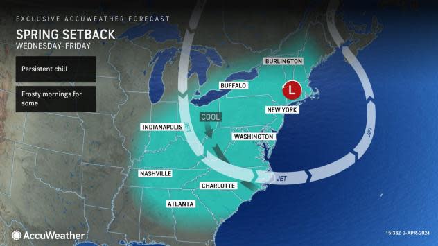
From the middle of the week to Saturday, cold, gusty winds will make it feel more like February rather than early April in many cases. Northwest winds on the storm's backside will average 15-30 mph, with gusts of 40-45 mph common and occasionally higher.
From midweek to the start of the weekend, AccuWeather RealFeel® Temperatures at times will dip into the teens to single digits across the interior Northeast and even below zero where there is fresh, deep snow on the ground. Along the coast, RealFeel Temperatures in the 20s and 30s are likely much of the time.
It may take until the latter part of the weekend to early next week before the storm pivots far enough to the east to allow gusty winds and cold air to diminish in the region.
 |
Away from the windy zone on the storm's backside, calm conditions and a clear sky may allow a frost or freeze in portions of the Ohio Valley and interior South later this week. The conditions could spell trouble for blossoming fruit trees in the region.
As a consolation to the persistent storm in the Northeast, the clear zone that develops in its wake could be in just the right spot for good viewing conditions for the upcoming solar eclipse on April 8.
 |
Want next-level safety, ad-free? Unlock advanced, hyperlocal severe weather alerts when you subscribe to Premium+ on the AccuWeather app. AccuWeather Alerts™ are prompted by our expert meteorologists who monitor and analyze dangerous weather risks 24/7 to keep you and your family safer.
