
 Yahoo News
 Arctic blast to invade central, southern and eastern US prior to midmonth


Arctic air is on the move across western and central Canada and will soon sweep into the western and central United States later this week before reaching the East by midmonth. Energy demands will surge, and the cold may be so severe as to put those exposed at risk for serious health concerns, while frozen pipes may lead to extensive property damage, AccuWeather meteorologists warn.
A storm that pushed into the Northwest on Wednesday will strengthen as it reorganizes over the Central states and evolves into a major blizzard for the Midwest from Friday to Saturday.
 |
The strong winds generated by the storm combined with the high pressure building 1,000 miles to its northwest will help to usher the cold air southward over the Plains, Mississippi Valley, Midwest and eventually some parts of the East Coast.
Temperatures will plunge well below zero over much of Montana. On Friday, the high temperature may be no better than 20 below zero at Great Falls, Montana. During Friday night, a low near or lower than 30 below zero is expected, which is likely to break the record of 30 below zero set in 1971.
Actual temperatures will dip well below zero at night over the northern Plains this weekend. Many areas from the Dakotas and Nebraska to Minnesota may struggle to get back to zero during the daytime on at least one weekend day.
Around Chicago, where deep snow is likely to be on the ground in the wake of the blizzard, gusty winds will lead to blowing and drifting of the snow this weekend with difficult and dangerous travel. AccuWeather RealFeel® Temperatures will be below zero much of the time and will dip to dangerous levels at night. As actual temperatures dip below zero, the braking efficiency of freight and passenger trains may be affected.
 |
In the Midwest and Northeast, the air passing over the open waters of the Great Lakes will help to take the edge off the severe cold. However, the cold will still pack a punch. Strong winds accompanying the cold blast will lead to rapid ice formation on the Great Lakes, and spray and overwash will freeze along the lakeshores. The Arctic blast will lead to bands of heavy lake-effect snow immediately after the storm. There is the potential for snow to be measured in feet where the snow bands persist.
The colder air will race up to the spine of the Appalachians Friday and then spill over the mountains this weekend thanks to strong gusty winds that may lead to another round of power outages. Those residents who end up losing power from the storm could be in the dark and shivering this weekend as temperatures strongly trend downward.
 |
Bitterly cold conditions are in store for several professional football games this weekend as the playoffs get underway. The coldest game of the weekend could be in Kansas City, where temperatures Saturday evening could drop below zero during the game -- a shock to the system for the visiting team from Miami. The AccuWeather RealFeel® Temperatures may also remain below zero Sunday afternoon when Buffalo hosts Pittsburgh.
The plunging temperatures and severe cold may put a serious strain on energy demands in the Southern states. Actual temperatures at night will dip below zero as far south as parts of Oklahoma and the Texas Panhandle.
 |
Temperatures diving into the single digits may rival record lows in Dallas by Monday morning. Freezing temperatures will penetrate as far south as central Texas.
"The frigid air may exceed the intensity of the Arctic outbreak of December 2022 and rival the duration of the cold in February 2021," AccuWeather Chief Meteorologist Jonathan Porter said, adding, "Temperatures may stay below freezing for 72 hours straight in the Dallas area starting this weekend."
Deep, fresh snow cover over much of the Plains will provide insulation for the cold wave, allowing the frigid air to pack more bite farther south and east than if all of the Central states were free of snow cover.
Many locations from near the Gulf Coast to the Atlantic Coast north of Florida are likely to experience their lowest temperatures of the winter by the start of next week.
 |
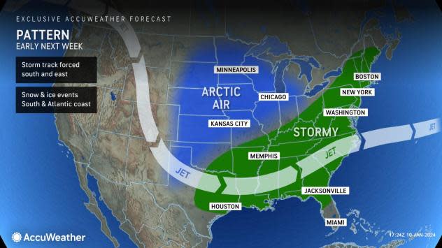
The deep penetrating Arctic air will likely help to set up a storm track that favors snow and ice in the southern and eastern tiers of the U.S. next week.
A storm may waste no time exploiting that setup with the potential for an expanding wintry precipitation zone from Texas and Oklahoma to Arkansas, Louisiana, Mississippi, Alabama and Tennessee Monday and then northward from Georgia to Virginia, Maryland, Delaware, Pennsylvania, New Jersey, New York and New England from next Tuesday to Wednesday.
 |
The potential storm could bring wintry precipitation to southern cities such as Dallas, Houston, Austin, Atlanta, Nashville and Charlotte, as well as a possible snap in the snow drought from Washington, D.C., to Baltimore, Philadelphia and New York City.
Want next-level safety, ad-free? Unlock advanced, hyperlocal severe weather alerts when you subscribe to Premium+ on the AccuWeather app. AccuWeather Alerts™ are prompted by our expert meteorologists who monitor and analyze dangerous weather risks 24/7 to keep you and your family safer.
