
 Yahoo News
 Central America faces Eastern Pacific Pilar, developing system in Caribbean


AccuWeather meteorologists have their eye on a couple of tropical systems from the eastern Pacific to the western Atlantic basins this week, and both of these systems may be a threat to Central America.
Tropical activity has trended much closer to the coasts of Central and North America in recent weeks as dry air and wind shear over the central Atlantic have become more hostile for development. Wind shear is the sudden change in speed or direction of breezes in the region that are not associated with a tropical system. Strong wind shear can prevent tropical development or cause a potent tropical system to weaken. An increase in wind shear is common during the latter part of October and into November.
 |
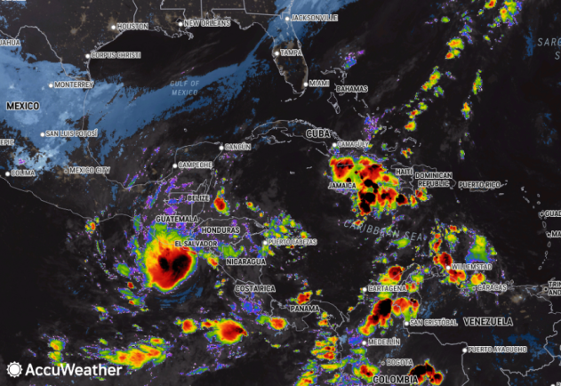
This image of the eastern Pacific and southwestern Atlantic was captured on Wednesday, Nov. 1, 2023. Left of center just off the coast of Central America is Tropical Storm Pilar. Another area being watched for tropical development is farther to the right in the eastern Caribbean. (AccuWeather Enhanced RealVue™ Satellite) |
Meanwhile, a plume of warm water in the Tropical Pacific associated with El Niño has fueled multiple powerful hurricanes in the eastern Pacific. In the wake of Category 5 Hurricane Otis, and earlier Category 4 Hurricanes Norma and Lidia, AccuWeather meteorologists have been closely monitoring a new system in the region.
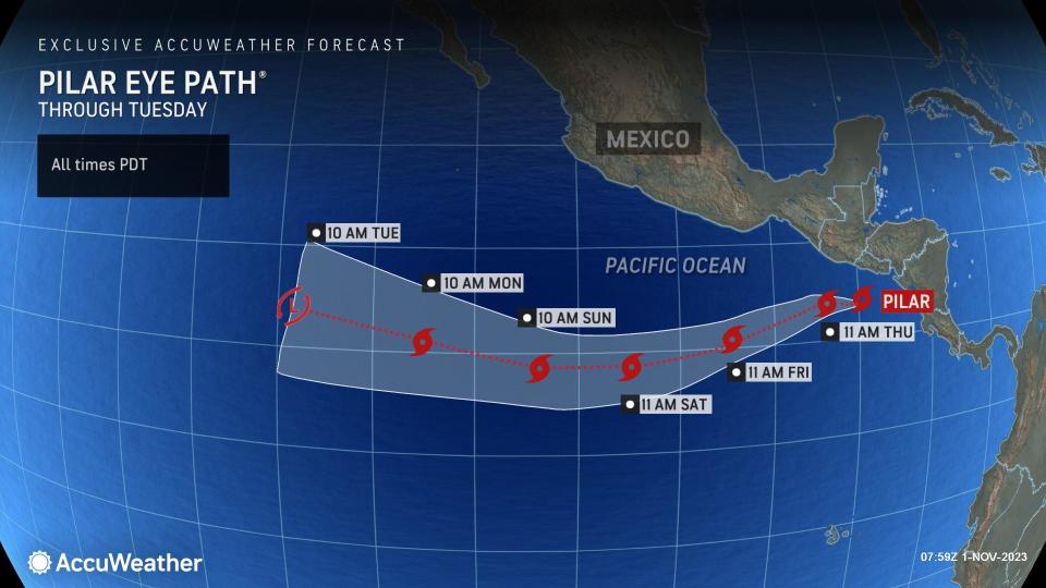
Even though the latest tropical system to bloom in the eastern Pacific had some trouble organizing initially, Pilar became a tropical storm over the weekend and is tracking closer to Central America during the first part of this week.
Tropical Storm Pilar drifted slowly northward and closer to El Salvador late Tuesday evening before starting to make its boomerang turn to the west during the early hours of Wednesday. Now that Pilar has made this turn, the storm is expected to slowly lose wind intensity as it tracks to the west over the open ocean.
 |
"The storm will approach El Salvador into Tuesday evening before a flip in steering winds occur and trigger a 180-degree turn to the southwest, which will take the system away from land on Wednesday," AccuWeather Senior Meteorologist Brian Wimer said.
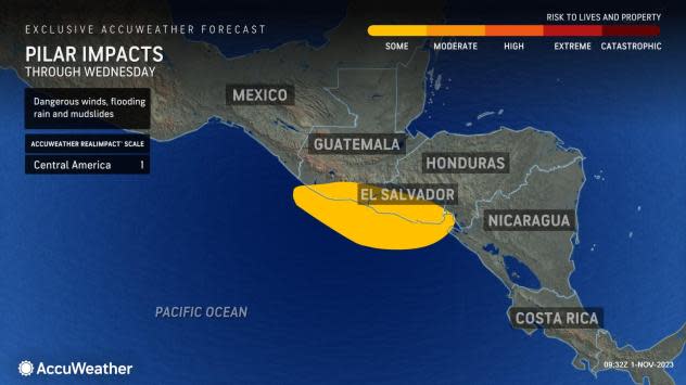
Heavy rain will continue into Wednesday and still can trigger flash flooding and mudslides along the southern tip of Guatemala, El Salvador and through the northwestern coast of Nicaragua. Because of these anticipated conditions, AccuWeather meteorologists have rated Pilar as a 1 on the AccuWeather RealImpact™ Scale for Hurricanes, which is a six-point scale ranging from "less than one" and 1 to 5.
 |
The greatest risk to lives and property in the region will likely stem from the consequences of heavy rainfall.
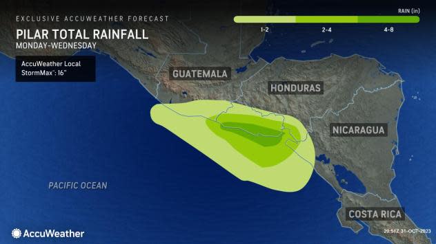
Rainfall totals of 1-2 inches (25-50 mm) are expected for the southern coast of Guatemala through the western coast of Nicaragua and into far northwestern Costa Rica. While this sort of rainfall over a day or two is not likely to cause problems, heavier rain over the span of just a few hours could trigger flash flooding and mudslides.
 |
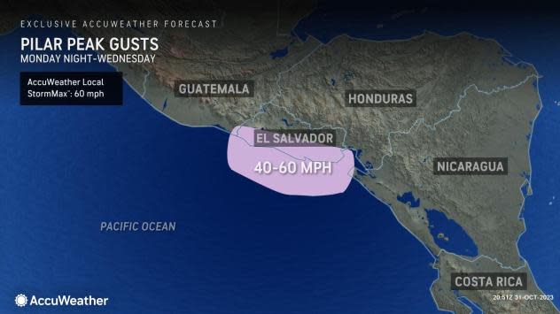
Rainfall of 2-4 inches (50-100 mm) is expected over the central Nicaragua coast through El Salvador. The heaviest rainfall of 4-8 inches (100-200 mm) with an AccuWeather Local StormMax™ of 16 inches (400 mm) is most likely along the El Salvador coast.
Within the strongest wind gusts in El Salvador, an AccuWeather Local StormMax™ of 60 mph (95 km/h) is expected. However, as Pilar continues to move away, rain and wind will subside in Central America.
 |
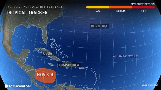
AccuWeather meteorologists are watching another system in the eastern Caribbean for tropical development this week.
 |
A budding zone of showers and thunderstorms may stay in a zone with much lower wind shear as it travels westward over the Caribbean this week.
The next name on the list of tropical storms for the 2023 Atlantic hurricane season is Vince.
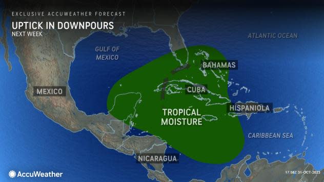
Any additional rain in Central America that overlaps that of Pilar from the first part of this week could add to the risk of flash flooding and mudslides.
There is also the potential for some of that moisture to linger in the western Caribbean, where it may be drawn north into the southeastern Gulf and perhaps the Florida Straits early next week, AccuWeather Meteorologist Joseph Bauer said. This could enhance showers and gusty thunderstorms in southern Florida, should that occur.
 |
AccuWeather will continue to provide updates on the tropical threats in the Atlantic and eastern Pacific. Both the Atlantic and eastern Pacific hurricane seasons do not officially end until Nov. 30.
Want next-level safety, ad-free? Unlock advanced, hyperlocal severe weather alerts when you subscribe to Premium+ on the AccuWeather app. AccuWeather Alerts™ are prompted by our expert meteorologists who monitor and analyze dangerous weather risks 24/7 to keep you and your family safer.
