
 Yahoo News
 How Could The US Bomb Cyclone Affect UK Weather?
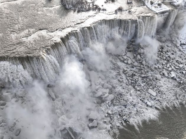
: An aerial view of the partially frozen Niagara Falls, which is on the border with Canada, on December 27, 2022
The US has experienced a devastating cold snap over the Christmas period.
As weather fronts often move across the Atlantic, the UK often experiences similar conditions just a few days later – so will we be affected soon, too?
Here’s what you need to know.
What happened in the US?
At leats 49 people have been confirmed dead across the US due to the weather conditions of the last few days, following a winter storm named Elliott.
Houses were covered in ice, transport was pretty much brought to a halt, with cars buried in snow drifts, and thousands were left without power.
Even Niagara Falls, near the Canadian border, partially froze over.
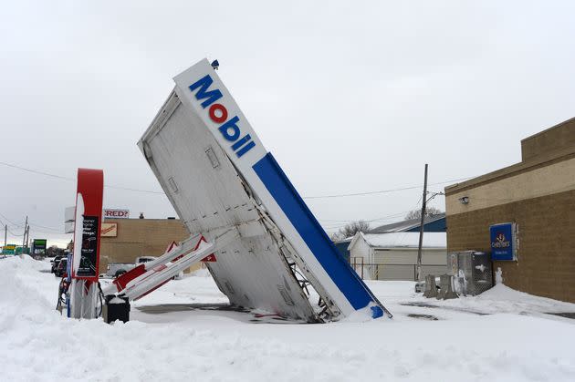
A gas station canopy lays on its side after high winds and heavy snow along Lake Shore Boulevard on December 27, 2022 in Lackawanna, New York.
A bomb cyclone is a term to describe how the sudden formation of a storm is similar to the detonation of a bomb. It’s when an area of low pressure suddenly deepens, bringing heavy rain and strong winds, and it’s the difference in temperature which triggers the drop in pressure.
The very cold Arctic air was pulled into the bomb cyclone, which pushed the climate to be even colder.
Temperatures reached as low as -45.6°C, meaning people could get frostbite in less than five minutes.
Will it reach the UK?
While the UK has experienced these weather bombs in the past (the last one was in 1987), the Met Office doesn’t think this one is going to reach Britain this time.
The weather experts explained that while the cold snap will affect the UK, it will not be the same as it was for the US.
The North Atlantic jet stream – a core of strong winds which are up to seven miles above the Earth – blows from west to east, meaning the UK often ends up with the weather first experienced in the US.
According to Sky News, Met Office meteorologist Simon Partridge said: “What effect (the bomb cyclone) has had is to strengthen the jet stream because the jet stream is basically driven by temperature differences.
“So the starker the difference in temperature between the northern edge of it and southern edge, the stronger the jet stream becomes.”
But, unsettled conditions for across the UK are expected for the next seven to 10 days, as the air currents are strengthened by the conditions blowing in from the US.
Partridge claimed that the overall “knock-on effect” of the weather is that the UK is “going to be a little bit milder” than it would normally be.
“We’re likely to see some wet and windy weather over the coming days, but there are currently no signs of any exceptionally cold weather heading for the UK,” the Met Office also explained in its latest update.
The cold weather fuelled a particularly “powerful Atlantic jet stream”, which will push low pressure systems to the UK – this is what will trigger the wet and windy weather over New Year’s Eve.
Will the UK be impacted by the cold snap in North America? ❄️
We're likely to see some wet and windy weather over the coming days, but there are currently no signs of any exceptionally cold weather heading for the UK 👇 pic.twitter.com/df9EMn54LT— Met Office (@metoffice) December 28, 2022
Yellow warnings have been issued for Scotland, from 3am on Friday December 30 for 15 hours.
This means flooding and travel disruption could ensue, although not on the scale experienced in the US.
The Met Office forecast believes that on Thursday, rain is expected in the far north and northwest with some showers by the afternoon, and snow on high ground. Wind, sunshine and showers are expected together.
Overnight, strong winds and rain will start to move in over the Scottish hills, with a growing risk of snow over northern Highlands come Friday morning.
Between Saturday and Monday, the country is likely to be unsettled and breezy, with rain or showers, with snow in Scotland, and “rather cold” although “mild in the south”.
Related...
Our New Normal: 10 Photos That Capture 2022's Extreme Weather In The UK
Why Your Boiler Breaks In Cold Weather And How To Fix It Fast
