
 Yahoo News
 I drove with an AI app that detects potholes on my commute and it's the new Google Maps
AI (artificial intelligence) is starting to emerge more and more into our daily lives and programmers are constantly finding new applications for the technology. Broadly speaking, AI allows computers to simulate human intelligence and problem-solving skills.
In decades gone by, it was often associated with sci-fi movies like The Terminator. But the technology has now made its way into our smartphones with popular apps like ChatGPT, where users can have open conservations with a computer.
Another new app featuring AI is called Stan, which allows drivers to document the quality of public roads using their phone cameras. Stan - short for Safer Travel Around Neighbourhoods - is a free and simple-to-use app launched by British developers in January 2024.
READ MORE: I visited 'forgotten' M6 services with a 'ghost bridge' that was once dubbed busiest in UK
Get breaking news on BirminghamLive WhatsApp, click the link to join
It works by allowing motorists to submit photos or record a journey like a dashcam. The photos and videos are then analysed using AI and the data is plotted on Stan's in-built map of the UK, which uses a colour-coded system to illustrate good and poor-quality roads.
BirminghamLive was invited to test out the app and see what we made of the findings. The only thing we needed to get started was to download Stan from the Apple store (it's also available on Android) and acquire a phone mount for a car windscreen.
Stan has two modes, Photo Mode and Drive Mode, and the latter is used to record journeys. Once you click on Drive Mode, you simply press the record button and the AI technology does the rest, with the screen going black.
It's worth noting that for clear results, you'll need to position your phone in the mount within the centre of the windscreen and ensure the camera is in focus. Having a little bit of your car bonnet in the frame is fine, but if the phone mount is also in view, it can blur the camera and the app won't pick up anything (which happened to me the first time around).
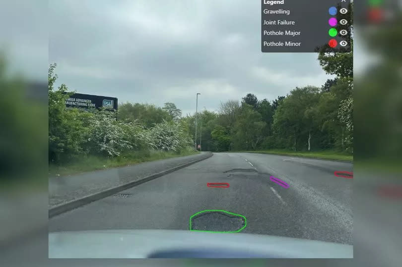
Stan assesses the road in 10-metre segments and provides a score out of five, from low to high: brown, red, orange, yellow and green. Your results will look like a snake on Stan's road map, with little circles representing the roads you've driven along.
To put Stan to the test, I opted to travel along a mixture of roads to see what results would be thrown up, including A-roads which I deemed would be well-kept and smaller B-roads which may feature potholes. Incredibly, the app is programmed to detect 45 types of road conditions and street assets, allowing it to tell different shapes and objects apart.
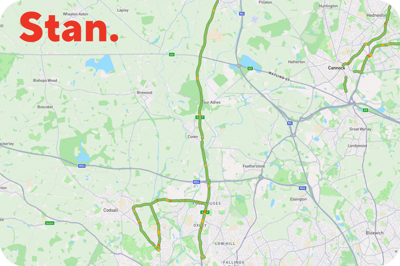
My journey began in Penkridge, Staffordshire, where I took the A449 Wolverhampton Road - a dual carriageway - down into Wolverhampton. The road received good scores overall, coming up green with only a few yellow patches.
It got more interesting though once we arrived in Wolverhampton. I took a right off the A449 and headed along Wobaston Road, passing through Pendeford and back over the Staffordshire border into Bilbrook.
Here, I was expecting to find potholes as the roads were quieter, rural and straddle two council borders - and I was not disappointed. The Stan app recorded several orange patches along Wobaston Road in Pendeford due to potholes.
Orange patches were also thrown up in Lane Green Road, Bilbrook, alongside Pendeford Avenue and Barnhurst Lane in Pendeford. Interestingly, the latter road previously featured more potholes but had been patched up by council officers after being highlighted by BirminghamLive.
We looped back to the A449 via Wobaston Road again and continued south into Wolverhampton, heading all the way down to the island in Bushbury with KFC. Along the way, several orange patches were recorded on the A449 in Oxley, where it passes Three Tuns Lane and a small stretch beyond.
Thankfully though, we did not experience any red or brown road segments along our journey overall. Once we returned home, it was time to upload the data and the results we got back were incredible.
Our entire route had been mapped on the Stan app, a trail of colourful circles representing where we'd driven, and it was really impressive to see how accurately Stan had analysed the road. Looking at one orange spot on Wobaston Road, I remembered where I'd had to swerve to around a pothole.
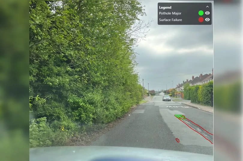
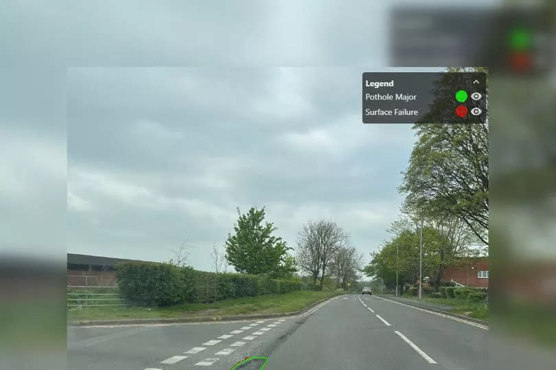
Although not available via the app, the Stan team were able to send me screenshots from my recording where different types of potholes had been picked up and analysed. This type of data is also shared with local authorities, including Birmingham, which Stan has started working alongside to fix and repair our roads.
The app uses a form of AI called SmartVision technology, also known as computer vision, which allows computers to analyse and gather information from moving footage. Although Stan was only used and launched in January, it was clear to see this technology has huge potential and represents what the future holds.
If you have potholes near where you live and feel there's been a lack of action from the council, I'd strongly recommend downloading Stan as this is another way to highlight the issue and inform other motorists.

