
 Yahoo News
 East Marsh fly-tipping hot spot to be transformed into twelve homes - planning decisions round up
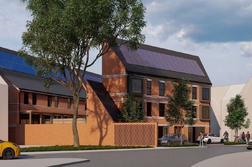
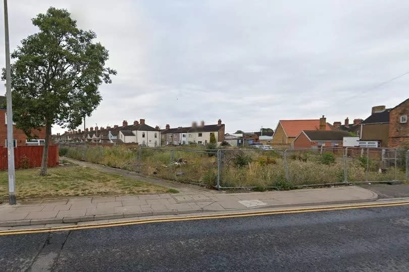
An 'eyesore' Grimsby brownfield site that has been prone to fly-tipping will be turned into 12 homes and two commercial units.
Belmont Property Developments Ltd sought permission for eight terraced houses, two commercial units, a store and four flats above these. The site is disused brownfield between Pasture Street and Wragby Street, East Marsh.
Objections were made by neighbours about parking pressures, the number of homes on the small site, and issues bin wagons already have getting down the roads. North East Lincolnshire Council's planning committee unanimously approved the scheme.
Read More:
The homes will all have solar panels on their roofs. Read on below to find out more about the Pasture Street development and other decisions reached by the council's planning committee in recent days.
East Marsh 12 homes
Sixteen parking spaces will be created at the Pasture Street development, one for each home. The flats will be one bed each, while the terraced housing is to be split between seven three-beds and one two-bed.
The terraced homes will face Wragby Street, and the commercial units and flats towards Pasture Street. The type of commercial units have not been specified.
The land is currently disused brownfield. "It's being built in a place that was prone to fly-tipping and an eyesore," said committee member Cllr Janet Goodwin, speaking to Grimsby Live following the decision. She welcomed the investment the development represented for the area.
A handful of residents objected to the proposal, hence why councillors decided on it. A Fraser Street woman said in her objection she was very concerned the development "on that small piece of land is going to create a serious problem for current residents". She questioned if refuse trucks would be able to get down Cavendish Way and commented: "Fraser Street is already having issues with numerous cars, adding more houses is just adding more pressure."
"This proposed new building will only make it worse," commented another objector about existing parking issues. Council highways, however, raised no objections, viewing the proposals as acceptable to highways safety and amenity.
HMO refusal
Staying in East Marsh, a complicated case of a seven-bed House in Multiple Occupation (HMO) lawfulness certificate for a property in Heneage Road was refused. Ward Cllr Steve Beasant had called it into the planning committee, stating as his reason for this: "Residents have concern that this seven-bedroom HMO will cause anti-social behaviour and have an impact on the local community."
It was already recommended for refusal by planning officers, though not on anti-social behaviour or community impact grounds. Essentially, the recent new owner had to prove a continuous ten-year existence as a seven-bed HMO. Officers obtained a "number of supporting but also contradictory pieces of information", a report to the committee states. These proved an HMO's existence back to 2012, but did not conclusively show it has been a seven-bed HMO.
Consequently a certificate for lawfulness on existing use was recommended for refusal. Councillors did unanimously reject it. However, there was conclusive evidence for more than ten-year use as a six-bed HMO.
This leaves the applicant open to getting a lawful certificate for this, which also because of being fewer than seven beds, can be done under permitted rights, without any possible councillors' say. The applicant has also indicated their intention to propose to turn it into an eight-bed HMO in future, too. This means this HMO site could well appear again.
Waltham public footpath
Finally, councillors approved getting a definitive map modification order (DMMO) to enshrine a new public footpath in Waltham. The footpath is not the longest, starting from Church Lane to public footpath no. 67, half the distance to Ings Lane. Waltham Parish Council sought its designation.
The council's planning committee decided in December 2019 to defer the extinguishment of part of footpath no. 67 until this claimed public footpath's verification had been sorted. Twenty-two user evidence statements were submitted for this new public footpath, though four were by people who have not used it themselves.
The earliest use submitted dated back to 1963, to access allotments that are located between Ings Lane and Church Lane. The path's entrance on Church Lane also has an old finger footpath post next to it.
Now that councillors have approved it, its designation will go through the process of getting sign-off by a Secretary of State before it officially becomes a public right of way.

