
 Yahoo News
 El Nino to bolster flood risk in South into February


 |
A quiet start to the week is underway across the South, but a looming pattern change will renew the risk of heavy rain and flooding by the end of the week.
People across the central and southern tier of the nation have been no strangers to heavy rain this past month, with many locations tallying up over 200% of the historical average rainfall for January. This month, over 8 inches of rain have fallen in places like Houston, Shreveport, Louisiana, and Little Rock, Arkansas.
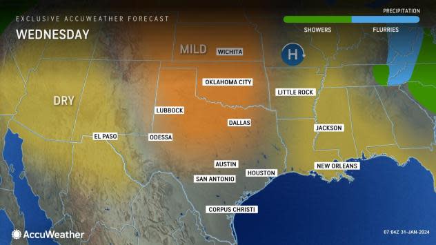
With a dry pattern in store for the rest of January across the South, these cities are not expected to measure additional rainfall, but as the calendar moves into February, a much more active pattern will return.
 |
A change in the jet stream pattern is expected to unfold over the United States as February begins. "This will force a separate storm track that will focus heavy precipitation across the southern tier of the United States," AccuWeather Senior Meteorologist Joe Lundberg explained.
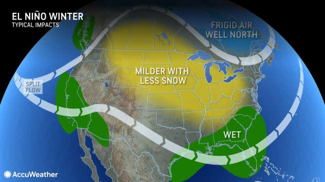
With El Niño conditions present this winter, above-average precipitation is a more common occurrence across the southern United States. The upcoming weather pattern will resemble what is typically seen during an El Niño winter.
 |
An El Niño pattern often ushers in an active storm track and resultant wetter conditions than the historical average across southern parts of the U.S. |
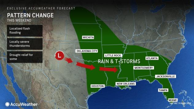
The signs of the changing weather will arrive first in the West Coast between Wednesday and Thursday, bringing heavy rain and mountain snow. The storm will continue to shift into the Southwest, into Thursday and Friday, setting the stage for a wet weekend across the South.
As the storm exits into the southern Plains on Saturday, humid air flowing out of the Gulf of Mexico will bring a risk for heavy rain across much of Texas. Travelers along Interstate 10, 20, 35 and many others across the state may want to plan on extra time to get to their destinations due to areas of heavy rain and slowed travel. Airports will likely face a similar risk, with delays or cancellations possibly caused by the wet weather.
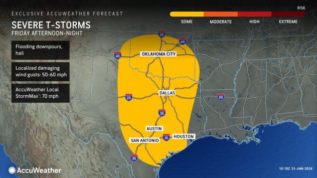
AccuWeather meteorologists are closely monitoring the severe weather potential with the storm system as it advances eastward. Strong thunderstorms can develop across Texas and Oklahoma Friday afternoon and night. Any of these thunderstorms could produce hail and damaging wind gusts up to 50-60 mph, with an AccuWeather Local StormMax™ of 70 mph.
 |
Farther east across Florida, residents and vacationers may want to consider planning outdoor activities for Saturday as the storm remains focused farther west. As the storm shifts into the day on Sunday, people in Orlando, Tampa and even Miami may want to keep an umbrella handy as rain will return to the forecast.
Many rivers across the South remain near or in flood stage in the wake of the multiple rounds of rain in recent weeks. Although not at flood stage, the Mississippi River has also had a notable bump in water levels.
"The recent barrage of storms during January by way of rain in the lower portion and both rain and melting snow in the Arkansas, Ohio and Missouri basins has raised water levels well past historically low levels," AccuWeather Senior Meteorologist Alex Sosnowski said.
The expected deluge of rain this weekend will likely prompt flooding concerns; however, the silver lining is that it will continue to benefit areas plagued by the ongoing drought conditions across the region.
Want next-level safety, ad-free? Unlock advanced, hyperlocal severe weather alerts when you subscribe to Premium+ on the AccuWeather app. AccuWeather Alerts™ are prompted by our expert meteorologists who monitor and analyze dangerous weather risks 24/7 to keep you and your family safer.
