
 Yahoo News
 England weather map turns red in 30C Iberian plume scorcher in just weeks
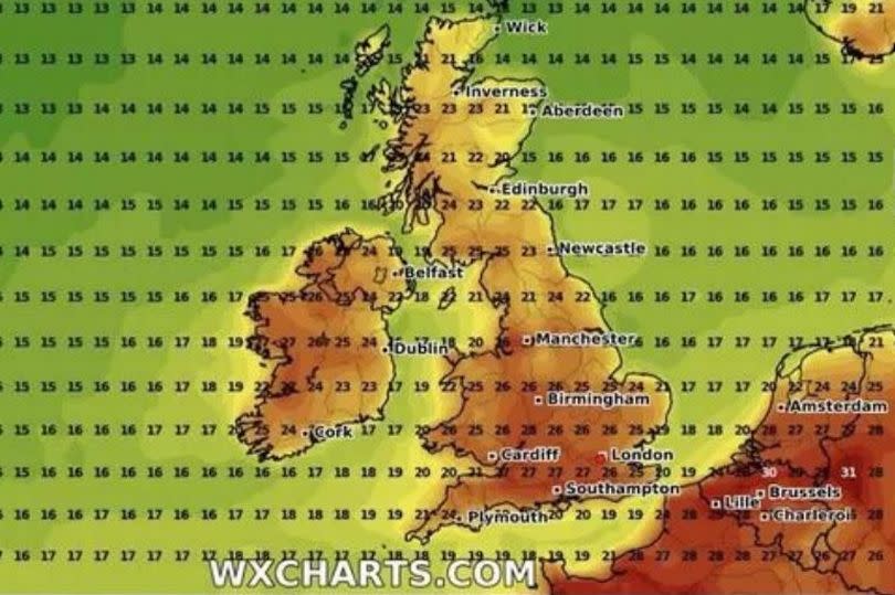
Summer could be on its way as a weather map turns red with a 30C Iberian plume scorcher in just weeks. The new WX Charts maps and charts reveal warm air moving up from the Iberian peninsula around July 23 - July 24.
The south of England and London are set to see the warmest weather, hitting between 27C and 30C, reports The Mirror. For Coventry and Warwickshire, the map shows the mercury hitting 26C.
This is a far cry from the temperatures we have seen of late and could be the glimpse of summer so many have been wishing for. But, for now, temperatures are set to remain 'below average'.
READ MORE: All of the new faces on West Midlands' most wanted list including Coventry man
READ MORE: Coventry council review after reports of 'stampede' and 'underage drinking' at Godiva festival
That is according to the latest local online Met Office report, which shows that while it is going to be drier as we head towards the end of the week, temperatures will not be rocketing. The latest local forecast is as follows:
Today:
Mainly cloudy with a few mostly light showers in the north and west of the region. The odd glimmer of brightness in places. Breezy at times and feeling fairly cool. Maximum temperature 20C.
Tonight
Staying mainly dry this evening and overnight with clear spells in the south. Thicker cloud in the north with showery rain and drizzle later. A slightly cooler night. Minimum temperature 10C.
Thursday
Grey skies with a few spots of rain or drizzle. The odd brighter interlude developing by the afternoon. Light winds but feeling rather cool for July. Maximum temperature 20C.
Outlook for Friday to Sunday
A good deal of dry albeit rather cloudy weather through this period. Isolated heavy showers on Friday and Saturday. Temperatures generally below average but feeling warm in any sunshine.
Sign up for our FREE daily newsletter here for all the latest news about Coventry.

