
 Yahoo News
 Exact time Scotland to be hit by 400-mile wall of rain as weather to stay warm
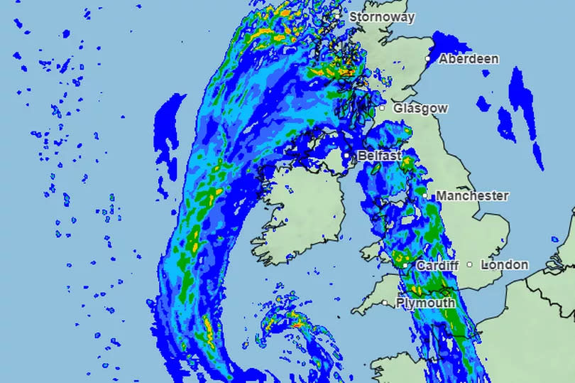
Scotland is set to see heavy rain this week thanks to a massive weather front set to span the length of the UK.
After a weekend of 25C heat and thunderstorm warnings, the start to the week is to be another mixed bag of clear and rainy skies. Monday (May 13) will be mild before a massive wall of rain is to reach the southwest later today as it migrates from the west.
The latest weather maps from the Met Office show the aggressive wet front reaching the west coast from 4:30pm this afternoon. As it continues to travel, it is set to span about 400 miles by 8pm, stretching as far north as Oban all the way to Plymouth in southern England.
Ahead of these heavy rains, BBC meteorologist Gillian Smart said "lots of dry weather" is in store for the the country early on Monday. While skies are to remain largely cloudy, temperatures will still be warm, ranging between "the high teens if not low twenties".
Speaking on Monday's forecast, she said: "There will be quite large areas of cloud around and a scattering of showers mainly affecting western Scotland and there's that more persistent rain getting into the southwest later on.
"Some mist and cloud affecting the Aberdeenshire coast, at times a scattering of showers over Shetland but it is still fairly warm temperatures."
This wet weather is to worsen later in the evening and overnight "turning heavy for a time" before becoming "lighter and patchier" showers through early Tuesday morning. Tonight's temperatures are "very much on the mild side" holding out in the teens in some areas
Looking to Wednesday, it will be a milder day for areas in the north, but dull and wet for the majority of the country.
She added: "Tomorrow cloudy with outbreaks of rain for central and southern Scotland nudging northwards. It will be the Highlands and the northeast seeing the best brightness and still feeling quite warm."
Met Office five day forecast
Today
A band of rain gradually spreads into southern and western parts of the UK, with some showers across northern Scotland. Elsewhere will be largely dry with spells of sunshine. Cooler under the rain but staying warm in the sunshine.
Tonight
Rain will move into the rest of England and also southern and western Scotland. Clear spells ahead of the rain band, with clearer but showery weather following in the southwest.
Tuesday
Largely dry and bright across the far north, with bright spells and showers across southern and western areas. Rather cloudy elsewhere with outbreaks of rain, turning heavy in places.
Outlook for Wednesday to Friday
Remaining changeable with a mix of sunshine and showers. The showers heavy at times, with perhaps some longer spells of rain at times. Temperatures falling back to closer to average.
Join the Daily Record's WhatsApp community here and get the latest news sent straight to your messages.

