
 Yahoo News
 Full list of areas hit with Met Office thunderstorm and rain weather warnings across UK
The UK is bracing for thunderstorms and heavy rain this week with a number of yellow weather warnings in place.
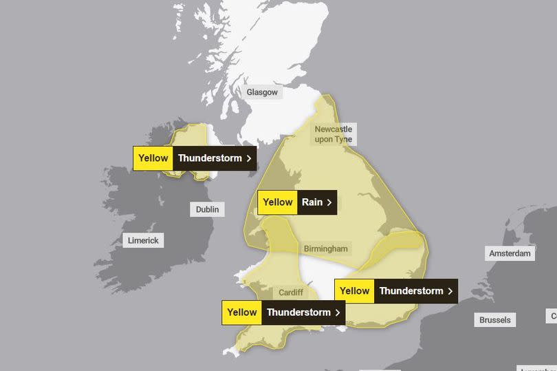
The Met Office has issued three yellow thunderstorm alerts for today (Tuesday May 21), impacting parts of Northern Ireland, Wales and areas of southern England. Two yellow rain alerts spanning until Thursday (May 23) have also been issued for north England, the midlands and parts of Scotland.
The forecaster warned of difficult driving conditions, road closures and potential delays and cancellations of train and bus services. Power cuts could also occur, while there's a 'small chance' homes and businesses could be flooded quickly.
The thunderstorm warning in Northern Ireland is in place between 8am this morning until 9pm tonight. The Met Office said some areas could see up to 30 mm of rainfall in just an hour or two, with the wettest spots perhaps seeing as much as 50-60 mm. Hail and lightning may be secondary hazards in places.
The areas affected are:
County Antrim
County Armagh
County Down
County Fermanagh
County Londonderry
County Tyrone
The second thunderstorm warning, covering south west England, Wales and some of the west midlands, is in place between 12 noon and 9pm tonight. The Met Office said: "There is a lot of uncertainty over exactly where the heaviest rain will occur... Many places will see 30-40 mm of rain, while a few areas may receive 60-80 mm. There is also a small chance that a few upland areas could see much higher totals, in the order of 100-150 mm."
The areas affected are:
South West England
Bath and North East Somerset
Bristol
Cornwall
Devon
Dorset
Gloucestershire
North Somerset
Plymouth
Somerset
South Gloucestershire
Torbay
Wiltshire
Wales
Blaenau Gwent
Bridgend
Caerphilly
Cardiff
Carmarthenshire
Ceredigion
Conwy
Denbighshire
Gwynedd
Merthyr Tydfil
Monmouthshire
Neath Port Talbot
Newport
Pembrokeshire
Powys
Rhondda Cynon Taf
Swansea
Torfaen
Vale of Glamorgan
Wrexham
West Midlands
Herefordshire
Shropshire
The third thunderstorm alert, covering parts of London, south east and east England, is in place from 12 noon until 11.59pm tonight. The Met Office said: "Across the warning area, 20-30mm in 1 hour or less is possible (but perhaps most likely to the south of London), with a few places perhaps receiving 40-50mm in 2-3 hours."
The areas impacted are:
East of England
Bedford
Cambridgeshire
Central Bedfordshire
Essex
Hertfordshire
Luton
Norfolk
Southend-on-Sea
Suffolk
Thurrock
London and South East England
Bracknell Forest
Brighton and Hove
Buckinghamshire
East Sussex
Greater London
Hampshire
Kent
Medway
Milton Keynes
Oxfordshire
Portsmouth
Reading
Slough
Southampton
Surrey
West Berkshire
West Sussex
Windsor and Maidenhead
Wokingham
Rain warnings
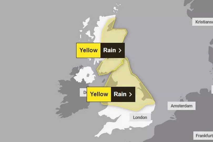
The first yellow rain warning doesn't come into force until quarter past midnight on Wednesday morning (May 22). It extends until 6am on Thursday morning (May 23).
The areas impacted by the warning are:
East Midlands
Derby
Derbyshire
Leicester
Leicestershire
Lincolnshire
Northamptonshire
Nottingham
Nottinghamshire
Rutland
East of England
Bedford
Cambridgeshire
Central Bedfordshire
Norfolk
Peterborough
London & South East England
Milton Keynes
North East England
Darlington
Durham
Gateshead
Hartlepool
Middlesbrough
Newcastle upon Tyne
North Tyneside
Northumberland
Redcar and Cleveland
South Tyneside
Stockton-on-Tees
Sunderland
North West England
Blackburn with Darwen
Blackpool
Cheshire East
Cheshire West and Chester
Cumbria
Greater Manchester
Halton
Lancashire
Merseyside
Warrington
Wales
Ceredigion
Conwy
Denbighshire
Flintshire
Gwynedd
Isle of Anglesey
Powys
Wrexham
West Midlands
Shropshire
Staffordshire
Stoke-on-Trent
Telford and Wrekin
Warwickshire
West Midlands Conurbation
Worcestershire
Yorkshire & Humber
East Riding of Yorkshire
Kingston upon Hull
North East Lincolnshire
North Lincolnshire
North Yorkshire
South Yorkshire
West Yorkshire
York
The second rain warning covers much of Scotland and is in place from 12 noon on Wednesday (May 22) until 6pm on Thursday (May 23). The Met Office said there is a chance that the heaviest outbreaks could become 'slow-moving' over Moray and northern Aberdeenshire, and to a lesser extent Lothian and Borders.
Should this happen then some places could see 60-80 mm of rain falling in 12 hours, with a very low chance of 100 mm.
The areas covered by the warning include:
Central, Tayside & Fife
Angus
Clackmannanshire
Dundee
Falkirk
Fife
Perth and Kinross
Stirling
Grampian
Aberdeen
Aberdeenshire
Moray
Highlands & Eilean Siar
Highland
SW Scotland, Lothian Borders
Dumfries and Galloway
East Lothian
Edinburgh
Midlothian Council
Scottish Borders
West Lothian
Strathclyde
Argyll and Bute
East Ayrshire
East Renfrewshire
Glasgow
North Ayrshire
North Lanarkshire
South Ayrshire
South Lanarkshire

