
 Yahoo News
 Heatwave to hit three regions with temperatures soaring above 20C
A heat blast will sweep the nation, turning three regions orange with raised temperatures, leading to another potential heatwave, according to the UK's latest weather maps
The past week witnessed rain and cloud cover engulfing the country, a stark contrast to the 30C highs and unbroken sunshine we enjoyed days earlier. There has been a temperature dip simultaneously, with certain areas cooling down by an average of 10C in comparison to last week.
Describing the current weather cycle as "unsettled and changeable", the Met Office predicts continued dominance of rain and cloudy conditions in the medium term. However, recent weather charts indicate a possible change within a fortnight, hinting towards a spike in temperatures.
READ MORE: DWP PIP claimants could be due £11,000 back payments - see if you're affected
Don't miss the biggest and breaking stories by signing up to the BirminghamLive newsletter here.
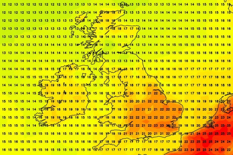
Netweather forecasters have shared charts suggesting a return of late June-level warmth early this month, courtesy of European coasts. From July 10th, the map displays three regions turning orange as temperatures once again enter the 20C range.
The southeastern area, particularly, is predicted to be impacted by atmospheric conditions from France and beyond, reports the Mirror.
By July 10th, Eastern England, Southeast England and London could experience temperatures ranging between 20C to 23C, expected to linger over the next few days. Weather maps spanning July 16th hint at thermometers staying predominantly in the 20C zone across Southeast England, maintaining highs around 21C.
The Met Office's long-range forecast, which covers the period from July 8 to 17, paints a similar picture. It suggests that the recent gloomy weather will make way for typical July temperatures.
The forecast reads: "The unsettled and changeable theme is expected to continue through the majority of this period."
"Cloud and rain-bearing systems will cross the UK from the west or southwest at times, accompanied by periods of stronger winds, but there are likely to be drier interludes too, with the best of the more settled weather in the east. With a generally southerly wind direction, temperatures are expected to rise back to the July norm from the cool beginning to the week, with the potential for wafts of warm continental air to affect the southeast at times."
The forecast concludes: "Into the second week, there are tentative signs that conditions could gradually become a bit more settled, though temperatures are likely to remain around average overall."

