
 Yahoo News
 Tornado warning ends in eastern Ontario
The latest
As of 10:00 p.m. on Thursday, a severe thunderstorm warning was issued for Ottawa, eastern Ontario, and northern parts of Gatineau.
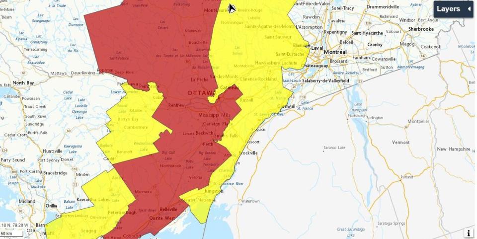
A tornado warning issued by Environment Canada about 100 kilometres southwest of Ottawa has ended.
The tornado warning affected parts of Central Frontenac, western Lanark county, and the Kaladar, Ont., region Thursday afternoon.
It had ended by 7:40 p.m., although the area is still included in the ongoing tornado watches issued for western Quebec and parts of eastern Ontario including Pembroke, Bancroft and Barry's Bay.
As of 8:45 p.m., the area around Barry's Bay and Bancroft was also under a severe thunderstorm warning.
Environment Canada says the hail is up to the size of a quarter and wind gusts are reaching up to 120 kilometres per hour.
A severe thunderstorm watch was also still in effect as of 8:45 p.m. for the region around Ottawa and South Frontenac.
Conditions are favourable there for severe thunderstorms that may produce a tornado this evening, Environment Canada said.
Tornado watches mean conditions are favourable for possible tornadoes, while tornado warnings mean a tornado has been reported or there's good evidence one is imminent. The same is true of severe thunderstorm warnings and watches.
If a tornado forms, residents are advised to stay away from exterior walls and windows, ideally in a basement or on the ground floor, and to get out of vehicles.
Forecasters say the storm could also bring winds gusting over 100 km/h, heavy rain and large hail.

