
 Yahoo News
 'Icelandic storm' set to hit northern England next week
An 'Icelandic storm' is set to hit parts of England next week, as Brits are being told to prepare for the extreme weather.
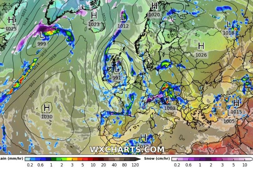
Major low-pressure could provide some colder weather soon, according to the latest weather maps. Forecasters predict the pressure system will make landfall in the north of England towards the end of Saturday, April 27.
This will be before the majority of rain and snow falls on the day after, Sunday, April 28. The UK is set to receive the end of the low-pressure, which originated off the south coast of Greenland and will head east to Iceland on Friday, April 26.
READ MORE:
Faces of killers, conmen and drug dealers in court this week
Warning as cases of 'particularly serious' infection known as '100-day' whooping cough soar
Moving in to Saturday, the weather is expected to shift southeast, which will make it head to the UK, Birmingham Live reports. An initial burst of rain is predicted from around midday, affecting Northern Ireland, Wales, the west of Scotland and northwest of England.
Up to 1cm of rainfall is forecast for every hour in the most extreme of cases. By midday on Sunday, the eye of the low pressure system is project between Northern Ireland and Scotland, reports the Mirror.
In the evening, snow could appear in the northwest of England, according to WXCharts. A long range weather forecast has been released by the Met Office, indicating low pressure will take over from Thursday, April 25 to Saturday, May 4.
At the start of next week, the UK is expected to see a shift from drier conditions, to more unsettled weather. Their forecast explained: "High pressure will likely be retreating to the northwest of the UK at the start of this period, with conditions turning generally more unsettled than the previous few days as low pressure becomes more dominant.
"Wet weather is perhaps more likely to develop in parts of the south and east, with western and especially northern areas hanging on to the best of any drier interludes, though all parts may have some rain at times." They added: "Onshore winds along eastern coasts will likely make it feel rather cold at times, though for all parts temperatures will often be a little below average. Into early May, something of a north-south split looks possible, with relatively drier conditions further to the north and the greatest chance of rain further to the south."

