
 Yahoo News
 ‘Immediate action needed’ as sea flooding threatens six towns on North Wales coast

Six flood warnings have been issued for the North Wales coast as the next area of low pressure blows in from the Atlantic. Natural Resources Wales (NRW) said flooding in these areas is “expected” today (Tuesday, April 9) and “immediate action is needed”.
NRW’s flood warnings encompass Conwy, Denbighshire and Flintshire. Details of all six are outlined below. Denbighshire Council has responded by closing three car parks in Prestatyn (Nova West, Beach Road East and Barkby Beach) and one in Rhyl (Central) as a “precautionary temporary measure”.
All floodgates have also been closed, including the new gates at East Rhyl and the Golf Club. The council advised residents to "take steps to limit the effect of flooding on you and your property".
READ MORE: Court order will force council to repair scenic Eryri lane after 4x4 group's legal action
READ MORE: The quiet North Wales farm at centre of global drugs network extending from Dubai to South America
A Met Office yellow warning for wind is already in force and flooding is around today’s high tide, which is due to reach 33ft in places. These will peak just after 11am on Anglesey and around midday further east.
With strong northwesterly winds, expected to gust to 40-50mph, this could produce a sea surge and lead to inundation. Rivers already swollen with water from Storm Kathleen could overflow too.
RNLI Rhyl warned: “With very high tides (high water at 12pm) and strong north westerly winds forecast, it is very likely the waves will be on Rhyl promenade in areas. Please stay well back from the waves and water. Water ankle deep, moving fast enough can sweep and adult off their feet.”
Today’s low has been named Storm Pierrick by the French equivalent of the Met Office. The north of France has born the brunt but strong gusts of up to 60mph were due to hit England’s southern coast overnight. The North Wales Live Whatsapp community for top stories and breaking news is live now - here’s how to sign up
The effects are being felt across Wales today. North Wales Storm Watch said of Storm Pierrick: “Initially arriving across southwest Wales, in the early hours of Tuesday, and reaching North Wales and northwest England during Tuesday morning.
“Gusts will reach 40-50mph widely, with 60 or 65mph gusts expected for exposed coasts of southwest and west Wales overnight.” A Met Office yellow warning for wind is in place for much of the Welsh coastline, running until 3pm.
As well as flood warnings, NRW has issued a flood alert that covers the entire North Wales coastline, from Bangor to Chester, and parts of the southern and eastern coast of Anglesey. The environmental body has warned of possibly “dangerous” waves and is asking people to be careful on beaches, promenades and coastal footpaths.
Flood warnings on North Wales coast
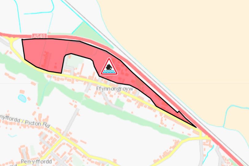
Ffynnongroyw frontage
Where: Parts of Ffynnongroyw, including Mormant Street, Airfield Avenue and the A548.
Threat: The high tide is at 12.15pm. The tide level is expected to reach 5.53 metres above sea level. Wave overtopping at the sea front is expected to occur between 11.15am and 1.45pm. The properties closest to the sea front are most at risk.
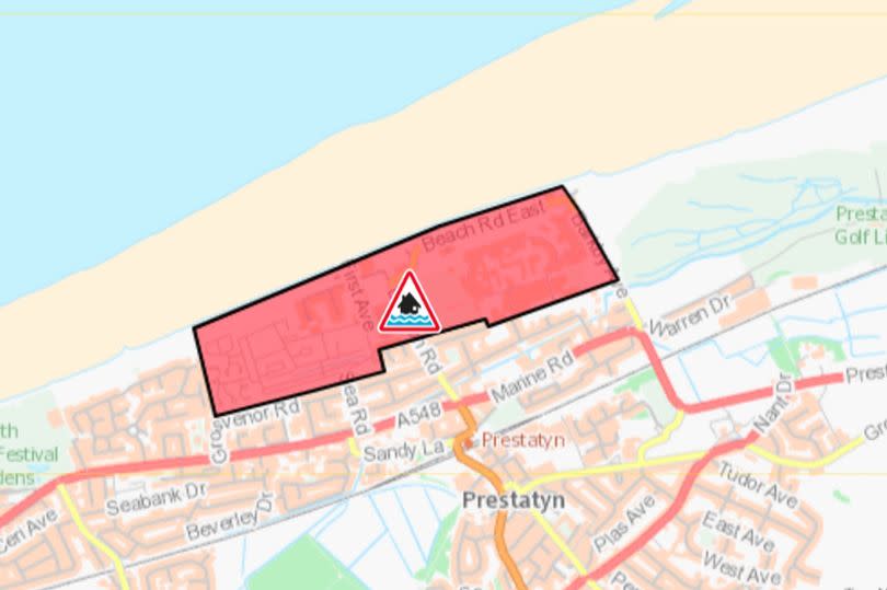
Prestatyn Beach Road
Where: The frontage from Lido Beach Caravan Park to The Beaches Hotel including Beach Road West, Beach Road East and Pontins Holiday Village.
Threat: The high tide is at 12pm. The tide level is expected to reach 5.19 metres above sea level. Wave overtopping at the promenade is expected to occur between 12.15pm and 2.pm. The properties closest to the promenade are most at risk.
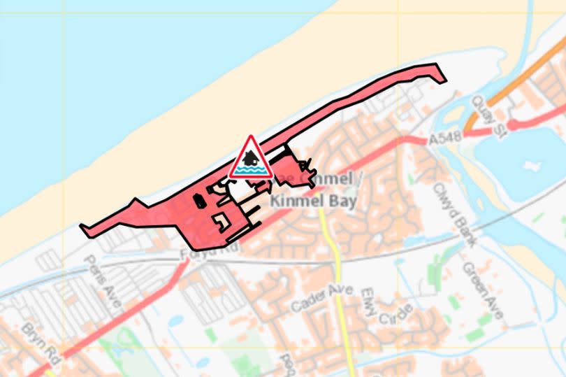
Kinmel Bay Promenade and Sandy Cove
Where: The frontage from Sunnyvale Holiday Park to Golden Sands Holiday Park, including the Promenade and parts of the Sandy Cove Estate.
Threat: The high tide is at 12pm. The tide level is expected to reach 5.08 metres above sea level. Wave overtopping at the promenade is expected to occur between 12pm and 2pm. The properties closest to the promenade are most at risk.

Llanddulas
Where: Parts of the village on Beach Road.
Threat: The high tide is at 12pm. The tide level is expected to reach 4.97 metres above sea level. Wave overtopping at the sea front is expected to occur between 10.45am and 1pm. The properties closest to the sea front are most at risk.
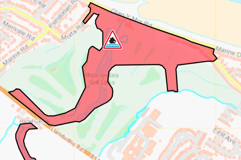
Penrhyn Bay
Where: Properties on Penrhyn Avenue and Morfa Road including the golf course.
Threat: The high tide is at 12pm. The tide level is expected to reach 4.86 metres above sea level. Wave overtopping at the promenade is expected to occur between 11am and 12.45pm. The properties closest to the promenade are most at risk.
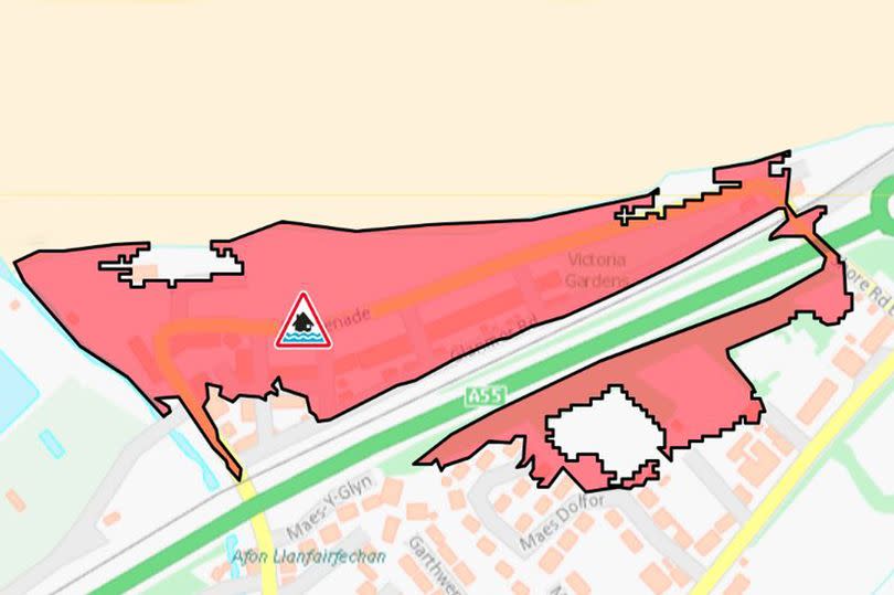
Llanfairfechan
Where: Parts of the village including Carradog Place, Shore Road, Glanmor Road and the Promenade.
Threat: The high tide is at 11.45am. The tide level is expected to reach 4.61 metres above sea level. Wave overtopping at the promenade is expected to occur between 10:15am and 1.15pm. The properties closest to the promenade are most at risk.
Dogs warning
The safety message has been repeated by RNLI Llandudno. The station’s water safety team is urging people not to take any chances in “ferocious winds which will easily blow you over in exposed areas” on the coast. Sign up for the North Wales Live newsletter sent twice daily to your inbox
It has a special mention for dog walkers. “Pets will find their own way back to the shore, it may be much harder for their owners,” said the team. “Do not be tempted to enter the water to retrieve a pet. The water in the sea and in rivers is extremely cold at present and survival times if you fall in are limited.”
The Met Office expects skies to brighten later on as rain clears away to the northeast. However, more rain is expected on Wednesday, with the forecaster warning of “further wet and windy weather”. Thankfully, Thursday and Friday should be mostly dry, with lighter winds and just the odd shower, it added.
Find out what the weather is up to near you

