
 Yahoo News
 Kent weekend weather forecast shows heavy rain and thundery showers set to batter county

As the weekend approaches, so too does a band of wet and windy weather as parts of Kent face the chance of thundery showers over the coming days. Forecasts from the Met Office anticipate a prolonged spell of rain sweeping across the county following today's drizzly start (July 5).
Further rainfall is expected to linger throughout the south east region during the late afternoon and overnight, with breezy winds along the coast. Weather maps show the downpours will be at their heaviest and most widespread from approximately 6pm.
At around 7pm, showers of up to 16mm an hour are anticipated towards the north of the county, particularly around Dartford and Gravesend, while lighter rain will blanket the majority of Kent. Met Office meteorologist Alex Burkill said: “There will be some rain around, especially towards the south, because of a waving front here.
Read more: Red Arrows route over Kent today as rain threatens flypast
Get Kent's latest breaking news and top stories on WhatsApp
“That’s then going to bring some more rain overnight before that clears away with a showery theme then following behind for both the rest of Saturday and also Sunday.” Looking ahead, Alex added: “More wet weather then feeding in from the south west as we go overnight.
“So we are going to see some heavy persistent rain spilling its way north-eastwards across parts of England, perhaps Wales as well as we go through this evening and overnight, eventually clearing away towards the North Sea as we head towards the early hours of tomorrow morning”.
Saturday (July 6) is looking to be another day of showers, with the Met Office advising that rainfall will turn heavy and potentially thundery at times in the south east. Forecasts show particularly heavy showers over Ashford, Canterbury, Thanet and Tunbridge Wells at around 10am, as well as Dover towards the late morning and early afternoon.
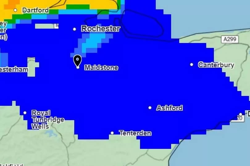
In these places, downpours could reach up to 32mm an hour at times. Temperatures are expected to keep around average for this time of year throughout the day, peaking at 19C, with some drier spells possible during the afternoon.
Similar trends are then expected for Sunday (July 7), when again sunny spells and heavy showers have been forecast. Once more, the Met Office advises that these could turn thundery in places as the heaviest downpours are forecast for Medway and Maidstone between 10pm and 1pm.
Any sunshine is expected to turn hazy by Monday, with cloudy skies and more rain on the way at the start of the new week. Conditions during the week that follows are expected to fluctuate considerably, particularly for this time of year, with the Met Office predicting a real mixture of weather during this time.
The long range forecast for Tuesday, July 9 to Thursday, July 18 states: “Confidence in the weather patterns at the beginning of this period is unusually low, with an erratic transition from cool, bright but showery weather over the previous weekend to something more unsettled, particularly in the south and west, likely to be underway.
“Overall the period is expected to be predominantly unsettled; successive areas of cloud and rain moving in from the Atlantic and shorter settled interludes in-between.” The forecast goes on to state that there is a chance for some warm spells in the south east during this time, as some weather charts have recently predicted the possibility of heatwave-like conditions in Kent later this month.
Get more news from KentLive straight to your inbox for free HERE.

