
 Yahoo News
 Los Angeles Braces For Worst Of Storm: Heavy Rain, Winds 45-50 MPH, “Extensive Street Flooding” Possible
Spring 2023 in Southern California looks a lot like winter 2023 in Southern California.
The second day of spring in and around Los Angeles brought another in a seemingly endless stream of atmospheric river events and about an inch of rain to most of the region, with more to come this evening.
More from Deadline
Southern California Theme Parks Close Due To Storm; 100 mph Winds Recorded Near Magic Mountain
Late-Winter Storm Has Los Angeles Bracing For Yet More Rain, 40 MPH Winds And Potential Flooding
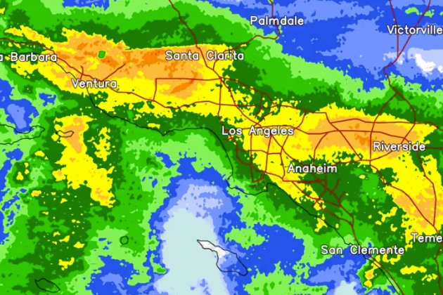
Up to 3 inches of rain could fall in coastal and valley areas by the time the storm subsides Wednesday, with foothill and mountain areas seeing 3-6 inches, according to the National Weather Service. Most of the region already is near double its average seasonal precipitation. The Department of Water and Power headquarters downtown, for example, has seen 32 inches thus far, according the L.A. Public Works data. The seasonal average for this time of year is about 17 inches. That means by Wednesday, the seasonal total could be double the average.
The NWS issued a flood watch for most of the Los Angeles area through Wednesday afternoon, with “extensive street flooding and flooding of creeks and rivers are possible.” A weather service statement indicated: “Tuesday to Tuesday night there is a slight risk (15% to 40% chance) for excessive rainfall and flash flooding along and west of the mountains with a marginal risk (5% to 15% chance) of flash flooding for our deserts. Mainly snow is expected at higher mountain elevations.”
Flooding and mud closed the Southbound I-5 connector to southbound to State Route 110 right lane in Elysian Park earlier this morning (the stretch later was reopened).
Update: Clean-up is underway! https://t.co/PInp8hWmEW pic.twitter.com/X7HR4vsXmn
— Caltrans District 7 (@CaltransDist7) March 21, 2023
Several other stretches of highway between Santa Barbara and Ventura counties as well as in the local mountains are also closed, per a CalTrans tweet.
*SR-2 in Angeles National Forest*
SR-2 remains CLOSED from Mt. Wilson Rd. to Big Pines Hwy. Multiple slides west of SR-39 & a washed out roadway at mile post 46 / Windy Gap. Closure updates at https://t.co/O37QesJHpw pic.twitter.com/Bbyx0EprDn— Caltrans District 7 (@CaltransDist7) March 16, 2023
Snow reduced visibility near Mt. Wilson to “a big ‘nope,’ today” according to Caltrans District 8, which serves L.A. County.
Visibility is at a big “nope,” today. Please consider travel when conditions are more favorable. If you must travel, be prepared and stay safe. If you are traveling to the mountains, please bring your chains and put them on off the roadway. We can’t plow when blocked. #Caltrans8 pic.twitter.com/3jW7rRkZkC
— Caltrans District 8 (@Caltrans8) March 21, 2023
A wind advisory will be in effect for most of the region until 11 p.m. Tuesday, with gusts from 45-50 mph possible. A more severe high-wind warning is in effect for Orange County coastal and inland areas until 10 p.m. Tuesday.
The Antelope Valley also was under a high wind warning, with gusts possible up to 75 mph. One weather station above Magic Mountain clocked 102 mph gusts early this morning, prompting the closure of the park today. Santa Anita also canceled its races.
A winter storm warning will be in effect until 11 p.m. Wednesday in the San Gabriel Mountains and in the 5 and 14 Freeway corridors. Forecasters predicted accumulations of 2-5 feet of snow above 6,000 feet, with 10-20 inches possible between 5,000 and 6,000 feet, and 2-10 inches between 3,500 and 5,000 feet — accompanied by winds gusting to 75 mph. According to the NWS, several inches of snow could fall in the Grapevine section of the Golden State (5) Freeway.
Forecasters said the morning burst of rain likely will taper off into the early afternoon, followed by another wave of precipitation later in the day. They noted that the first wave of the storm was actually weaker than anticipated, though some heavier rain was reported along the Los Angeles/Orange County line.
City News Service contributed to this report.
Best of Deadline
Sign up for Deadline's Newsletter. For the latest news, follow us on Facebook, Twitter, and Instagram.
