
 Yahoo News
 Met Office issues 39 hours of warnings for Wales

The Met Office has issued two separate warnings of torrential rain and storms due to hit different parts of Wales in the coming days.
The first warning, for thunderstorms, is for today (Tuesday) and covers nearly all of the nation. The second warning for heavy rain largely focuses on north Wales and runs all day on Wednesday into Thursday. In total the warnings span a total of nearly 39 hours.
An area of low pressure is approaching the UK from the east, bringing heavy and, in places, prolonged rainfall. The precise track of the low pressure will determine how much rain falls over land areas and how far west across the UK the heavy rain will reach.
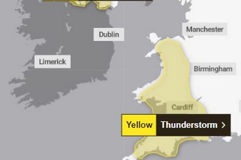
The first warning will be in place for nine hours from noon today until 9pm, covers a large part of Wales and warns of up to 20-30mm in one hour.
READ MORE: A family's history is the secret of the rebuilt The Vulcan pub
READ MORE: WRU chief publicly accused by 'sad' chairman
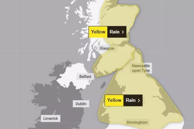
The second warning is in place from 12.15am in the early hours of Wednesday morning through to 6am on Thursday, a span of 29 and three-quarter hours. It says heavy rain may cause some flooding and disruption to travel.
Here are the different warnings for Wales and what you can expect over the coming days:
Tuesday warning - Thunderstorms
In place from noon until 9pm
The warning states: "Heavy showers and thunderstorms are expected to develop during the afternoon across parts of southwest England, Wales and the West Midlands before slowly dying out during the evening. Many places will miss the worst, but where they do develop, some slow-moving and intense downpours are possible, giving accumulations of 20-30 mm in around one hour, and a lower likelihood of 40-50 mm in two to three hours in a few locations. Frequent lightning strikes and hail are also possible."
In Wales, the warning covers: Blaenau Gwent; Bridgend; Caerphilly; Cardiff; Carmarthenshire; Ceredigion; Conwy; Denbighshire; Gwynedd; Merthyr Tydfil; Monmouthshire; Neath Port Talbot; Newport; Pembrokeshire; Powys; Rhondda Cynon Taf; Swansea; Torfaen; Vale of Glamorgan; Wrexham.
Wednesday and Thursday warnings - Rain
In place from 12.15am on Wednesday until 6am Thursday
The warning states: "An area of rain is expected to develop across eastern and central England and then move northwestwards to affect northern England and north Wales during Wednesday afternoon. The area of rain could then become slow moving, heavy and persistent, especially over north facing hills, before clearing during Thursday morning.
" There is a lot of uncertainty over exactly where the heaviest rain will occur and this warning is likely to be updated. Many places will see 30-40 mm of rain, while a few areas may receive 60-80 mm. There is also a small chance that a few upland areas could see much higher totals, in the order of 100-150mm."
In Wales, the warning covers: Ceredigion; Conwy; Denbighshire; Flintshire; Gwynedd; Isle of Anglesey; Powys; Wrexham.
Talking about Wednesday, deputy chief meteorologist Dan Rudman said: “Low pressure is going to influence our weather from the middle of this week, bringing some heavy rain to parts of the UK. Eastern areas are most likely to see the highest rainfall accumulations, though this will depend on the precise positioning of the low pressure. It is important to keep an eye on the forecast as the detail becomes clearer, and it is possible Severe Weather Warnings will also be issued.”
As the area of low pressure moves north along the east coast of the UK, there will be further rain and may be some gusty north-westerly winds in parts of southern Scotland and northern England on Thursday.
The Met Office says that the low pressure will slowly fill by the end of the week and allow a ridge of higher pressure by Friday afternoon, bringing a short spell of more settled weather for many. During Saturday, a front may move in from the Atlantic bringing a band of rain to Northern Ireland and western parts of Scotland. This rain is expected to become lighter as it slowly moves eastwards across the UK through the rest of the weekend.
BBC Breakfast weather presenter Carol Kirkwood also gave some hope for the bank holiday weekend, saying that bank holiday Monday was "not looking bad".

