
 Yahoo News
 Met Office Surrey weather warning for thunderstorms tonight with flooding, power cuts and travel disruption expected

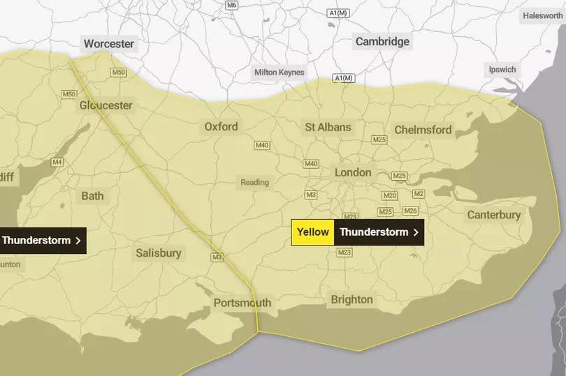
Overnight thunderstorms will bring lightning, flooding, and up to an inch of rain in as little as an hour to the south of England and parts of Wales, according to the Met Office. It comes as the forecaster issued a seven-hour yellow weather warning to residents and drivers in Surrey ahead of the Early May Bank Holiday weekend.
A rain radar map shows a band of heavy rain is set to sweep across Surrey in the early hours of Thursday morning (May 2) with between 16 and 32mm forecast in Guildford, Haslemere, and Woking. The warning will be in force from 11pm (May 1) until 6am (May 2) and covers all of Surrey, the South Coast, London, and up to Oxford, as well as Hampshire, parts of Essex, South Wales, and the Southwest.
Drivers have been warned of difficult conditions and road closures due to spray and sudden flooding while trains and buses may also be delayed or cancelled as a result of flooding or lightning strikes. The forecasters' prediction looking ahead to the weekend, however, shows a chance of sunny weather for the county amid cloudy conditions.
Read more: Surrey towns which could get a new Lidl as supermarket plans UK openings
Read more: 'Unimaginable' impact on green belt seals fate of Surrey sports club's expansion
The Met Office advised during the warning: “There is a small chance that homes and businesses could be flooded quickly, with damage to some buildings from floodwater, lightning strikes, hail, or strong winds.” It said people should consider if their location is at risk of flash flooding and to prepare a plan, if so.
The forecaster added: “Thunderstorms are expected to move northwestwards across some parts later this evening and overnight bringing spells of heavy rain accompanied by frequent lightning with potential for 15 to 25mm of rain to fall in one or two hours in a few places. Hail and gusty winds may also affect a few spots.”
What to expect
There is a small chance that homes and businesses could be flooded quickly, with damage to some buildings from floodwater, lightning strikes, hail or strong winds, The Met Office said
Where flooding or lightning strikes occur, there is a chance of delays and some cancellations to train and bus services
Spray and sudden flooding could lead to difficult driving conditions and some road closures
There is a slight chance that power cuts could occur and other services to some homes and businesses could be lost
Early May Bank Holiday forecast from the Met Office
Dorking
Saturday (May 4) - Mist changing to sunny intervals by late morning.
Sunday (May 5) - Sunny intervals changing to cloudy by late morning.
Monday (May 6) - Cloudy changing to light showers by early evening.
Farnham
Saturday (May 4) - Sunny intervals changing to cloudy in the afternoon.
Sunday (May 5) - Sunny intervals changing to cloudy by late morning.
Monday (May 6) - Cloudy changing to light showers by early evening.
Guildford
Saturday (May 4) - Sunny changing to cloudy in the afternoon.
Sunday (May 5) - Sunny intervals changing to cloudy by late morning.
Monday (May 6) - Sunny intervals changing to cloudy by late morning.
Horley
Saturday (May 4) - Sunny changing to cloudy by lunchtime.
Sunday (May 5) - Cloudy.
Monday (May 6) - Cloudy changing to sunny intervals by late morning.
Redhill
Saturday (May 4) - Sunny changing to cloudy in the afternoon.
Sunday (May 5) - Cloudy.
Monday (May 6) - Cloudy changing to sunny intervals by late morning.
Staines
Saturday (May 4) - Sunny changing to cloudy by lunchtime.
Sunday (May 5) - Cloudy changing to sunny intervals by late morning.
Monday (May 6) - Sunny intervals changing to cloudy by lunchtime.
Woking
Saturday (May 4) - Sunny changing to partly cloudy by nighttime.
Sunday (May 5) - Sunny intervals changing to cloudy by late morning.
Monday (May 6) - Cloudy changing to light showers by early evening
Forecast for the South East
Today:
Mist and fog clearing to leave sunny spells, particularly in the north and east. Some showers developing as temperatures rise, with an area of heavy showers arriving from the coast across western areas, clearing to leave some late sunshine. Maximum temperature 21 °C. Tonight, An area of heavy and thundery rain will likely move northwest across the region overnight. Northern areas perhaps remaining dry. Low cloud is also expected to spread inland overnight. Minimum temperature 11 °C.
Thursday:
Rather cloudy across the south with outbreaks of rain and showers, heavy at times with a risk of further thunderstorms overnight. Spells of warm sunshine for northern parts. Light winds. Maximum temperature 18 °C.
Outlook for Friday to Sunday:
Unsettled Friday with spells of heavy rain and thundery showers. Rain clearing northwards later leaving bright spells. Drier and brighter Saturday. Largely cloudy overnight and Sunday with showers or rain.
Long range - 5 May - 14th May
An uncertain period through the bank holiday weekend with the most likely result a warm but cloudy day Sunday with a few light showers, then increasingly cloudy with rain spreading from the west, though weakening as it does so, however there remains a broad spread of solutions with the threat of showery spells a common feature. Into the new week all areas are likely to see a mixture of showery periods or spells of rain, though generally drier conditions expected to develop through the following week away from the northeast as high pressure develops to the west. Sunniest conditions across the south, cloudiest in the north and east. Temperatures mostly a little above normal for early May.
Get more news from SurreyLive straight to your inbox for free here.

