
 Yahoo News
 Mexico's severe heat, drought have eyes for US


 |
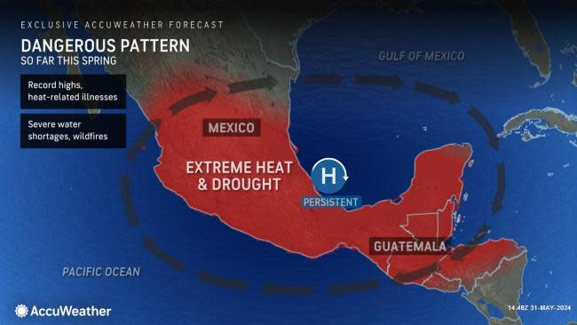
A tremendous dome of heat and drought has been affecting a large part of Mexico from the winter through the spring, and AccuWeather meteorologists warn that some of that will build northward into the southwestern and south-central United States this summer.
While the period from the winter to the early spring is typically a dry time of the year for much of Mexico, which tends to trigger drops in water levels and an increase in wildfires, this year has been especially dry and hot, and the country faces difficulties due to the ongoing drought and heat cycle.
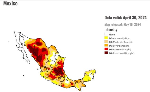
As of the start of May, 82% of Mexico was experiencing conditions ranging from abnormally dry to exceptional drought, according to the North American Drought Monitor. The worst category of drought affected 11.45% of the country.
This has been the worst drought for much of Mexico since April 2011, when only 4% of the country was not experiencing abnormally dry or drought conditions.
 |
With no significant moisture around to reduce the sun's powerful rays, the same drought has helped boost temperatures to record levels. Thus far, for 2024, Mexico's highest temperature recorded was 124 F at Galinas on May 9. This is less than 2 degrees from the all-time record high for Mexico of 125.6 degrees, set on July 28, 1995.
GET THE FREE ACCUWEATHER APP
•Have the app? Unlock AccuWeather Alerts™ with Premium+
Mexico City, located 7,340 feet above sea level, is nearly 2,000 feet higher than Denver. Mexico's capital city has broken almost a dozen daily record high temperatures this month alone. The sprawling metropolis experienced a monthly temperature departure of 10 degrees Fahrenheit in March, 8.4 degrees in April and 10.8 degrees in May. Typically, any temperature departure of 2 degrees or more is considered significant.
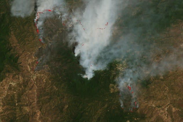
The hot and dry conditions have contributed to many large wildfires this spring in Mexico, significantly reducing the region's air quality and occasionally sending a significant amount of smoke into the southern U.S.
 |
As Mexico entered peak fire season in March 2024, dry and warm conditions helped fuel the flames of more than 100 active blazes across the country. This image shows smoke billowing from one such fire near the border of neighboring states Oaxaca (west) and Chiapas (east) in southern Mexico. (NASA Earth Observatory image by Wanmei Liang, using Landsat data from the U.S. Geological Survey.) |
"As the transition to summer begins in June, moisture from the tropics will increase over southern Mexico and slowly progress northward over the country," AccuWeather Long-Range Meteorologist Alex DaSilva said. "There already has been some influx of moisture into the southern part of Mexico in the form of spotty showers and thunderstorms in the past couple of weeks."
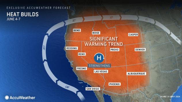
However, the massive heat dome parked over Mexico much of the spring will begin to shift northward and into the Southwestern and South Central states this summer.
"There is the potential for a prong of triple-digit heat to develop over the interior valley of California by the middle of next week," AccuWeather Lead Long-Range Meteorologist Paul Pastelok said. "But, most definitely, temperatures will trend upward significantly as a bubble of the Mexico heat moves up and into the western U.S."
 |
AccuWeather's long-range team expects a delayed and subdued North American monsoon this summer. This flip to a southerly flow of moisture tends to trigger a chunk of the region's yearly moisture supply through drenching showers and thunderstorms.
"It may take until midsummer for the monsoon to kick in, and there may be so little moisture that soil drought conditions develop over part of the interior Southwest," Pastelok explained.
AccuWeather does not expect any problems in California from water shortages into the first several months of 2026 due to ample rain and mountain snow during the past two winter seasons.
"The combination of drying brush in the summer heat and spotty, but mainly dry thunderstorm activity (lightning strikes with little or no rain) could lead to real wildfire problems, especially from parts of New Mexico to Idaho and the interior Southwest," Pastelok said.
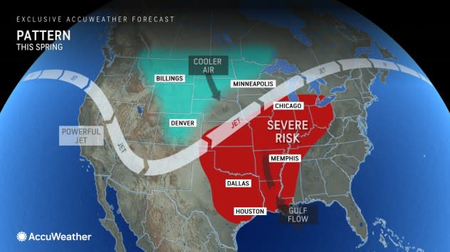
The same massive heat dome over Mexico may have been contributing to the frequency of torrential downpours and severe thunderstorms in the central U.S. this spring.
 |
Storms tend to erupt along the edge of a heat dome. This is because storms and downpours cannot erupt in the middle of the massive area of sinking air. Instead, the storms tend to erupt on the edges or areas of least resistance or where the air can rise more freely.
This spring, the U.S. has been experiencing its greatest number of tornadoes since 2011, which also happened to be Mexico's last big drought year. Flooding has also been a problem in portions of the southern Plains and South Central states.
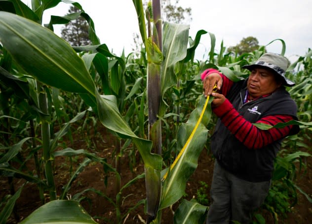
Rain may come too late for a successful corn harvest and other crops in Mexico.
AccuWeather's lead agricultural meteorologist, Dale Mohler, said Mexico is the world's eighth-largest corn producer, but the country does not export corn. Mexico is a large importer, buying most of its corn from the U.S.
 |
An agronomist measures and evaluates the blades of an organically grown native corn stalk on a farm outside of Apizaco, Mexico, Thursday, May 18, 2023. (AP Photo/Fernando Llano) |
"Sinaloa, located in west-central Mexico, inland from the coast, and Jalisco, near Mexico City, grow 37% of the nation's corn crop," Mohler said, "Both these areas have been hit hard by the drought."
A bad year for corn growing in Mexico could be good news for U.S. farmers because there may be a strong demand from Mexico for corn.
Want next-level safety, ad-free? Unlock advanced, hyperlocal severe weather alerts when you subscribe to Premium+ on the AccuWeather app. AccuWeather Alerts™ are prompted by our expert meteorologists who monitor and analyze dangerous weather risks 24/7 to keep you and your family safer.
