
 Yahoo News
 Northern Ireland yellow rain warning issued for areas by Met Office
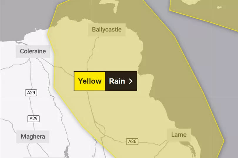
The Met Office has issued a yellow weather warning covering parts of Northern Ireland for later today.
The alert for heavy rain may bring some disruption to northeastern parts of Northern Ireland from 5pm on Wednesday until 10am on Thursday.
The forecaster said: "An area of heavy rain is expected to move westwards into eastern parts of Northern Ireland during Wednesday. Whilst many areas may only see modest amounts of rain, there is the potential for parts of Antrim in particular to see 30-50 mm of rain quite widely and perhaps in excess of 60-80 mm over windward facing higher ground."
READ MORE: LIVE updates as former DUP leader Jeffrey Donaldson's case returns to court
They added: "Rainfall should tend to ease later on Thursday morning. Strong north to northwest winds, perhaps gusting to 50 mph at times, will likely exacerbate any impacts from the rainfall."
Here's what to expect on the weather front over the next few days, according to the Met Office
Tonight:
Overcast with periods of rain across the east, turning heavy at times and increasingly edging into central areas. West mainly dry. Fresh to strong northwest winds, near gale over coasts. Minimum temperature 7 °C.
Thursday:
Rather cloudy. Rain focused in east and through the morning, turning patchy for the afternoon. Fresh to strong north to northwest winds, touching near gale around the coasts at first. Maximum temperature 16 °C.
Outlook for Friday to Sunday:
Friday cloudy with patchy rain, then sharp afternoon showers. Brighter spells and showers for the weekend with outbreaks isolated Saturday and building during Sunday.
UK long range weather forecast: Sunday 26th May - Tuesday 4th June
On Sunday, the weather is likely to be a mix of showers and warm sunshine. A band of rain may move in from the west later, but this will become weak as it pushes east across the UK.
By Bank Holiday Monday, there may still be some showers around, otherwise it will be dry and fine, and feeling warm in the sunshine. Into the following week, once any showers have cleared, more settled conditions are more likely for most, with the best of the weather likely in the southwest.
Rain may threaten northwestern areas at times, and there is a chance that southern or eastern areas may see the odd heavy or thundery outbreak of showers. Temperatures are likely to remain a little above average, with some regional variation.
For all the latest news, visit the Belfast Live homepage here and sign up to our daily newsletter here.

