
 Yahoo News
 Pipe-bursting cold, snow and ice threat to reach into the South


AccuWeather meteorologists are warning that a blast of bitterly cold Arctic air will surge southward through the Plains into Sunday and toward the Gulf Coast during the coming week, threatening lives, property and the power grid due to a prolonged period of subfreezing temperatures. The frigid air can also contribute to the season's first chance of wintry precipitation in the region.
"This will be the coldest air for the southern Plains since just before Christmas 2022," said AccuWeather Senior Meteorologist Joe Lundberg. "In addition to the cold, there is a risk of freezing rain, sleet and even snow in the region."
The same blast of bitter cold will also invade the northern and eastern United States, bringing record-low subzero temperatures for some and lake-effect snow for others. It may represent the most widespread and coldest air mass the country will endure all winter.
 |
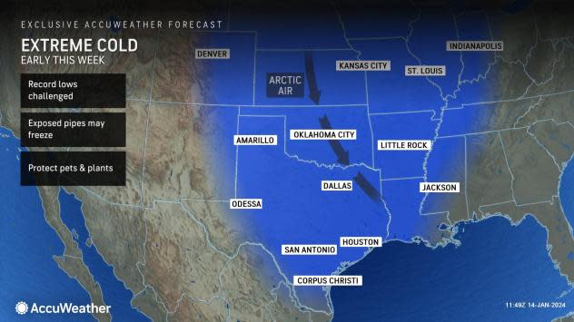
The bottom is about to drop out after a relatively average start to the year temperature-wise in the Plains and South. AccuWeather meteorologists say that in the wake of a winter storm that will blossom into a bonafide blizzard in the Midwest and behind a trailing cold front, Arctic air amassing in the Northwest will be unleashed south and east from late this weekend into Tuesday and beyond.
"The coldest air of the winter season thus far, transported directly from northwestern Canada, will surge across the northern Rockies and northern Plains," said AccuWeather Chief Meteorologist Jon Porter, "That air will then drive all the way south into Texas and other Southern states on Sunday."
In Dallas, high temperatures in the low-60s seen on Saturday will be replaced by low-20s on Sunday and on Monday, close to a whopping 40-45 degrees below the historical average for the middle of January. The mercury could dip into the single digits at night, challenging long-standing record lows.
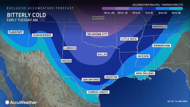
A short drive to the north and west will reveal even lower forecast temperatures, as near subzero readings could get as far south as Amarillo, Texas, and the Oklahoma City area. The entire region, all the way to the Gulf Coast around Houston, can experience AccuWeather RealFeel® Temperatures slipping below zero, meaning frostbite can occur in even a short amount of time spent outdoors.
 |
While the temperatures and the AccuWeather RealFeel® Temperatures will get shockingly low at times, the duration of the subfreezing temperatures is most concerning.
"Temperatures are forecast to stay below freezing in parts of northern Texas for 84 hours or more," said Lundberg. "This will stress the power grid because of a spike in heating needs."
It will take the area until Wednesday for the mercury to go back above freezing in Dallas and many other parts of the Southern Plains states.
Texans have become acutely aware of how the state's power grid can struggle in extreme temperature events. The severe and prolonged nature of the upcoming cold wave has AccuWeather meteorologists comparing this event to others in recent years.
 |
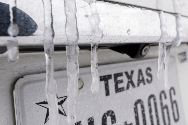
Icicles hang on the back of a vehicle Monday, Feb. 15, 2021, in Houston. A frigid blast of winter weather across the U.S. plunged Texas into an unusually icy emergency that knocked out power to more than 2 million people and shut down grocery stores and dangerously snowy roads. (AP Photo/David J. Phillip) |
"It does not appear this cold wave will be as long-lasting or intense as the historic and deadly outbreak that occurred in February 2021," said Porter. "However, this wave can be more intense and longer-lasting than the one that occurred just before Christmas in 2022, when the reliability of the power grid was also threatened."
Besides concern over the power grid, there are other worries about extended cold in the region. Uninsulated pipes that are exposed to the cold can freeze and burst, so experts recommend wrapping them or leaving the tap slightly open to prevent that disaster from occurring. In addition, there are year-round agricultural operations in parts of South Texas that can be impacted by subfreezing conditions.
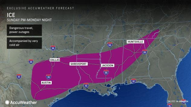
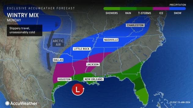
For a portion of the southern Plains and the Southeast, where severe cold is also forecast to arrive by early next week, it will be double trouble, as the chill will be accompanied by some travel-disrupting snow and ice, representing the first such instance of the season for many, say AccuWeather meteorologists.
 |
"Any time cold waves are accompanied by snow or ice, the impact to people, businesses and the power grid can be substantially amplified," warned Porter.
The chance of rain and snow, arriving after the cold rushes in, will be from a winter storm that will first bring more rain and heavy snow to the Northwest late this week and early this weekend. That storm will then move across the Rockies and combine with moisture coming off the Gulf of Mexico from Sunday into Monday, likely spreading a swath of wintry precipitation from Texas and Oklahoma east into the Mississippi Valley and a part of the Southeast.
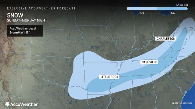
"A snowy, icy mess could be in the cards from the Lone Star State all the way east to northern Mississippi, northern Alabama and Tennessee," said Lundberg.
 |
While accumulations are not expected to be major, they will be significant by Southern standards, perhaps amounting to a couple of inches, with the heaviest snow expected to target a zone around the Arklatex or Ozarks and east into the Mississippi Valley. Such accumulations would be enough to snarl travel and shutter schools and businesses because of limited resources for snow removal in the region.
Tyler, Texas; Oklahoma City and Tulsa, Oklahoma; Fayetteville and Little Rock, Arkansas; Shreveport, Louisiana; Memphis and Nashville, Tennessee; and Huntsville, Alabama; as well as portions of Interstates 20, 22, 30, 35, 40, 49 and 59, are among the areas at risk from this slippery winter weather.
 |
The threat of slippery travel will not end after the snow and ice, as AccuWeather is warning that the consequences of the cold lingering for several days into the middle of next week can prolong the storm's impacts.
"In any areas where ice and snow do accumulate, it can remain for a couple of days because of the cold, prolonging slippery streets and sidewalks," said Porter. The weight of the ice on trees and power lines, combined with a gusty breeze expected behind the storm, can also cause power outages.
The bitter cold, snow and ice threat will not be limited to just the Plains and the South, as AccuWeather meteorologists are warning that millions in the Great Lakes and the Northeast will also be subject to harsh wintry weather through the middle of the month.
The eastward expansion of the Arctic air could make for a real mess where flood waters linger and then freeze. Similar problems could occur along some secondary roads where runoff continues in the wake of the big rain and wind storm into Saturday.
The same storm destined to bring snow and ice to a large part of the Southern states into Monday may take a northward turn along the Eastern Seaboard and could bring the mid-Atlantic its long-awaited snowstorm.
Want next-level safety, ad-free? Unlock advanced, hyperlocal severe weather alerts when you subscribe to Premium+ on the AccuWeather app. AccuWeather Alerts™ are prompted by our expert meteorologists who monitor and analyze dangerous weather risks 24/7 to keep you and your family safer.
