
 Yahoo News
 Quebec says 3 times more homes could be in flood zones under new mapping
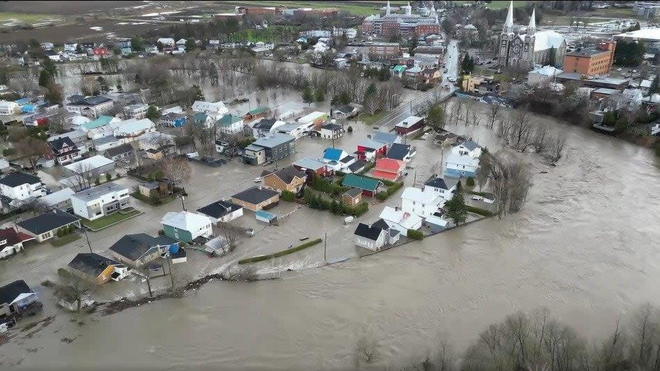
Some 55,000 more homes in Quebec will be in areas at risk of flooding — three times more than today — according to a new generation of flood maps coming from the provincial government.
Quebec officials released the estimates and announced the establishment of a new regulatory framework related to flood zones at a news conference Tuesday. Those new regulations will also apply to structures meant to mitigate flood risks like dikes and barriers, which are referred to in French as Ouvrages de protection contre les inondations (OPI).
Although the new maps have yet to be produced, officials expect that nearly 77,000 homes, or two per cent of Quebec's population, could find themselves in a flood zone compared to 22,000 today.
"In certain places in Quebec, the flood zone mapping has not been updated in 30 years," Environment Minister Benoit Charette said Tuesday. "We have to update our way of doing things based on the science, and that is what we are proposing today."
The maps will be produced in collaboration with municipalities in the coming months and the new flood-management plan as a whole will be the subject of public consultations with residents and municipalities this summer. The plan is expected to be implemented by 2025.
Currently, Quebec's flood maps are based solely on the recurrence of floods and are divided into high-risk and low-risk areas — where there is a five per cent and one per cent chance of a flood in any given year, respectively.
The new maps will designate areas of "flood intensity" by taking into account the frequency of floods, the water depth reached as well as the impacts of climate change.
The flood zones will now be classified by four levels, ranging from "very high" for regions with more than a 70 per cent risk of flooding over 25 years and over 60 cm of water expected, to "weak" in areas with a seven to 20 per cent risk of flooding over 25 years and less than 30 cm of water expected.
In a statement released Monday afternoon, the Communauté métropolitaine de Montréal (CMM) — which represents 82 municipalities in the greater Montreal area — welcomed the province's plan to revamp regulations related to flood management.
However, the CMM said it is worried about the effects the new framework will have on properties located behind OPIs, especially as it affects their value.
New limitations on construction
New regulations announced Tuesday stipulate that repair and renovation work can generally proceed in flood-prone areas, but rebuilding severely damaged structures in very high-intensity flood zones may be restricted.
Expansion in very high-intensity areas will also be limited to essential needs only. Additionally, construction of new buildings in flood-prone areas, even in low-intensity sectors, will not be permitted.
However, municipalities can mitigate risks by implementing flood protection structures such as dikes, which can lead to a reclassification to a lower-intensity zone.
The flood-management plan provides for stricter guidelines for municipalities to follow in order to prevent flooding, such as maintaining and monitoring flood prevention infrastructure.
Officials say the objective of the framework is not to relocate residents at risk, but to increase their security and protect their property as well as the environment.
Concerns regarding insurance rates
Asked about what the new flood zone maps will mean for insurance rates for affected residents, Charette said they may not have a direct impact as insurance companies generally use their own mapping criteria to assess flood risk.
In March, Desjardins Group, a major financial institution based in Quebec, announced it will no longer offer new mortgages in high-risk flood zones across the province. It also doesn't provide flood insurance in those areas.
The announcement sent shock waves through low-lying communities, from Charlevoix, north of Quebec City, to the suburban areas of Montreal.
Traditionally, it has fallen on the Quebec government to step in to help homeowners cope with the costs of flooding.
But after 2019, when flooding forced the evacuation of more than 6,000 residents of Sainte-Marthe-sur-le-Lac, Que., and damaged hundreds of homes, the government signalled its unwillingness to pay for repeated flood damage at the same address, imposing a new lifetime cap on compensation per home and financial incentives for people to relocate from homes in high-risk zones.

