
 Yahoo News
 Rain and strong winds could cause transport delays, Met Office warns
There is potential for flooding and transport delays because of strong winds and heavy rain set to hit parts of the UK on Thursday.
The Met Office has issued yellow weather warnings for parts of Wales, southern and western England, Northern Ireland and southern Scotland.
Strong winds and rain could impact areas including Cardiff, Plymouth, Truro, Exeter, Portsmouth, Bath and Brighton from 10am-7pm, it said.
It said some delays to road, rail, air and ferry transport are likely, with spray and flooding on roads possibly making journey times longer.
The flooding of a few homes or business is also possible, it added.
The weather service said there could be 10-22mm of rain, with 40-50mph gusts inland, rising to 60-70mph on exposed coasts.
⚠️ Yellow weather warning issued ⚠️
Rain and strong winds across Wales and parts of southern and western England
Thursday 1000 – 1900
Latest info 👉 https://t.co/QwDLMfRBfs
Stay #WeatherAware⚠️ pic.twitter.com/kxQfVaVHkU
— Met Office (@metoffice) November 23, 2022
The forecaster added: “A brief spell of heavy rain and strong, gusty winds perhaps causing some transport disruption and flooding.
“A narrow band of rain, heavy at times and perhaps briefly intense, will move eastwards late on Thursday morning and into the afternoon, clearing Kent during the evening.
“Ten to 15 mm is likely to fall in a one-to-two-hour period, with around 20 mm in a few places.
“With saturated ground, this is likely to lead to a fair amount of surface water on roads and flooding in one or two places.
“Strong winds will be an additional hazard with gusts of 40-50 mph inland and perhaps briefly 60-70 mph along some exposed coasts, especially in Cornwall, Pembrokeshire, Gwynedd and Anglesey.”
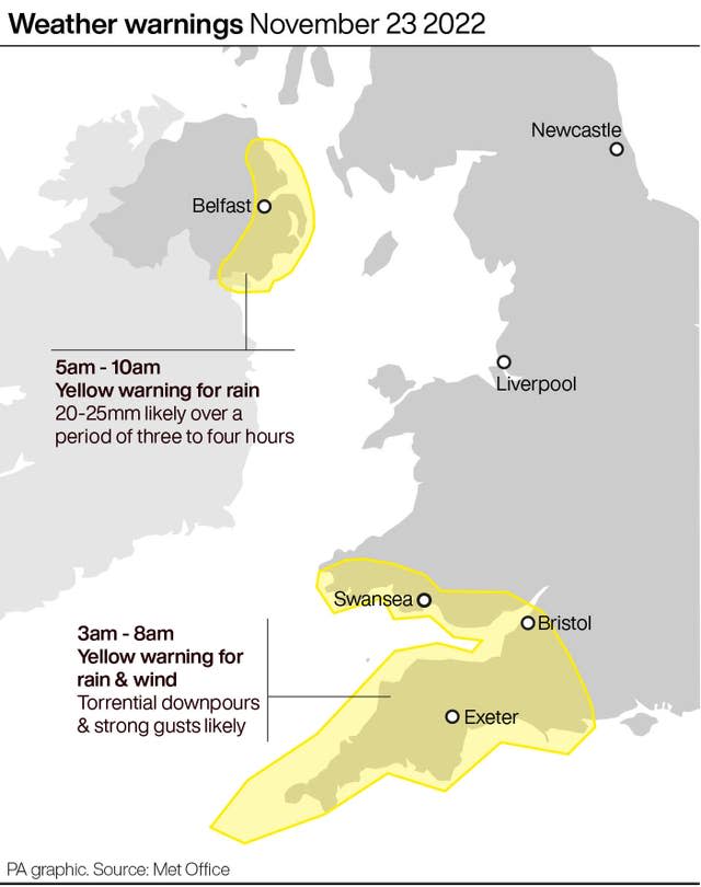
It warned that strong winds could sweep across parts of Northern Ireland, including Belfast, Newry, Londonderry and Omagh from 8am-2pm on Thursday.
Parts of southern Scotland such as Dumfries and Ayr are also set to be affected, it said.
⚠️ Yellow weather warning issued ⚠️
Strong winds across Northern Ireland and parts of southern Scotland
Thursday 0800 – 1400
Latest info 👉 https://t.co/QwDLMfRBfs
Stay #WeatherAware⚠️ pic.twitter.com/qzowSngyeF
— Met Office (@metoffice) November 23, 2022
It said some delays to road, rail, air and ferry transport in these areas are likely.
Some coastal routes, sea fronts and coastal communities could be affected by spray and or large waves, it added.
The Met Office adds: “A spell of strong southerly winds will develop during Thursday morning, with gusts of 40-50 mph inland and perhaps briefly 60-70 mph along some exposed coasts, accompanied by a short period of heavy rain.
“Winds easing from the west during the late morning and early afternoon.”
The Met Office’s current outlook for Friday to Sunday has forecast: “Showers easing on Friday, but with strong winds and rain moving in from the west through Saturday that will gradually clear from the north west during Sunday. Becoming mild this weekend.”
The Met Office issues warnings when severe weather has the potential to bring impacts to the UK, it states.
Its guidance states: “Yellow warnings can be issued for a range of weather situations.
“Many are issued when it is likely that the weather will cause some low level impacts, including some disruption to travel in a few places.”

