
 Yahoo News
 Rounds of severe thunderstorms, flooding rain target South


The combination of flooding downpours and gusty winds could be dangerous across the South as a pair of storms brings persistent threats into the weekend.
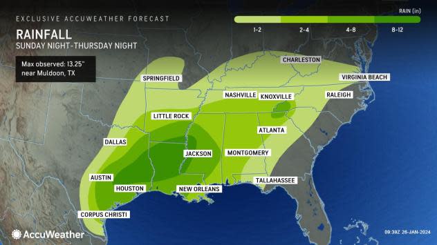
The week started with wet weather drenching portions of Texas, Louisiana and Arkansas. More than 3 inches of rain was reported from Sunday through Thursday in Tyler, Texas, while College Station, Texas, received over 5 inches in fewer than four days. In some cases, 5 to 8 inches of rain has poured down from northeastern Texas to western Alabama and southern Tennessee.
"Rounds of heavy rain and thunderstorms are expected to continue across the southern tier of the country through the weekend," said AccuWeather Senior Meteorologist Tyler Roys.
 |
A persistent wind flow out of the Gulf of Mexico will funnel extra moisture into the storm as it slides along the Gulf coast.
After spreading thunderstorms and rain to cities such as New Orleans, Nashville and Atlanta through Thursday, the storm will linger along the Atlantic coast through most of Friday.
Some of these thunderstorms brought damaging wind gusts to portions of Louisiana and southern Mississippi through the early evening hours of Thursday.
 |
Widespread rainfall amounts through Thursday night toppled 4 inches from Texas to central Mississippi. As much as 5 inches of rain fell in Houston through Thursday, while Jackson, Mississippi received almost 6 inches of rain.
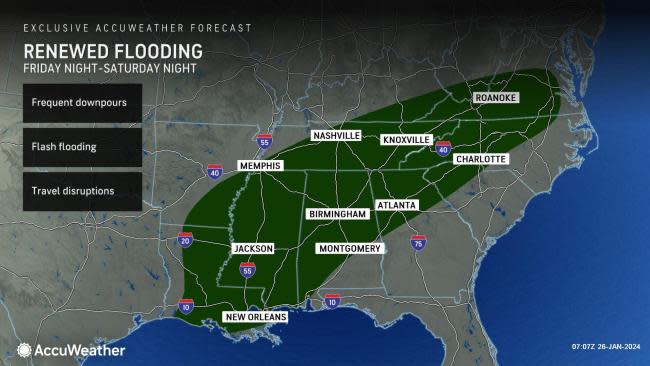
Although rain and thunderstorms will linger from the Carolinas to the Florida Panhandle on Friday, parts of the lower Mississippi River Valley will have a brief reprieve from the rain. However, another round of wet weather is expected for the weekend.
"The caboose in the train of storms will wring out more rain across the region from Friday night to Saturday night," AccuWeather Senior Meteorologist Alex Sosnowski said, adding, "More of the southern Appalachians and Piedmont areas will experience flooding problems as the rain pours onto the saturated ground."
Unlike the previous storm, the late-week storm is forecast to move more quickly, limiting the amount of possible rain. Rainfall totals are more likely to be limited to 1-3 inches with local amounts to 6 inches rather than climbing to the double digits.
Drivers out and about throughout the week should keep in mind that travel may be slowed by the persistent downpours, leading to reduced visibility or even roads covered in water. Motorists should consider leaving a little earlier to reach their destinations on time.
The core of the storm, and the potential for wintry precipitation, will move northward, but rain and thunderstorms are forecast to sweep from Texas to the Carolina and Florida coasts into Sunday.
 |
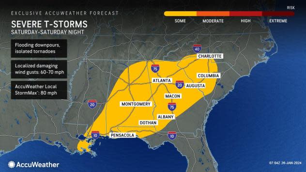
Even still, the thunderstorms have the potential to be robust. AccuWeather meteorologists are highlighting the potential for severe weather Saturday and Saturday night from the Florida Panhandle to North Carolina.
Flooding due to frequent downpours and recent rain will be the most widespread threat with these thunderstorms, followed by localized damaging wind gusts and the risk of some tornadoes.
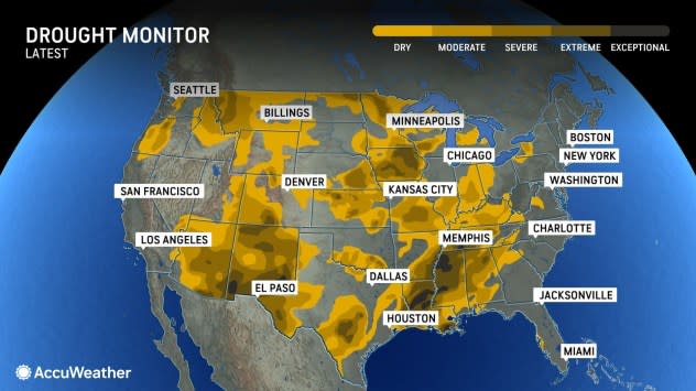
"While severe weather and flash flooding are concerns for the region into the weekend, much of the region is still in a drought and could use the rain in the long term," Roys explained.
 |
"However, while the long-term drought continues in the region, the torrential rains have begun to roll back the severity of the situation and have made the soil surface saturated. Water is running off into area streams, rivers and bayous and collecting in low-lying areas," Sosnowski said.
Portions of Louisiana, Mississippi and Tennessee have been in extreme or exceptional drought, the two most dire categories, for much of the winter. Conditions in some places, like southern Louisiana, have improved since November, but others have worsened.
A rather dry period seems to be in store for the final days of January, which eventually should help the ground absorb the rainwater from this week's events. Once that occurs, the week's rain is likely to improve conditions by making a dent in the drought.
Want next-level safety, ad-free? Unlock advanced, hyperlocal severe weather alerts when you subscribe to Premium+ on the AccuWeather app. AccuWeather Alerts™ are prompted by our expert meteorologists who monitor and analyze dangerous weather risks 24/7 to keep you and your family safer.
