
 Yahoo News
 Scotland rain map turns red showing exactly when downpour will fall hardest

Wet weather is ahead for Scotland as maps show where a deluge of rain will be particularly heavy.
The week has kicked off with a wet and cloudy start for many. Unfortunately, conditions do not appear to improve in the days ahead, with a torrent of rain the horizon, according to weather maps from WXCharts.
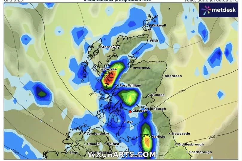
Among the weather fronts approaching is heavy rainfall on Saturday July 6. The wet weather stretches across most of Scotland, but the map - indicating rainfall above 5mm an hour - is concentrated on the coast of the Highlands. The rain is also set to be heavier in parts of Perthshire and the Borders.
As for today, the Met Office has reported outbreaks of rain sweeping eastwards. Temperatures are "struggling" under cloudy skies, with the warmest weather in the southeast. Highs will reach 18C in Glasgow, 16C in Edinburgh, and 14C in the northwest.
The national forecaster has warned of a cool week ahead, with a mix of sunshine and showery rain. Whilst the best dry, warm and settled weather will be in the south and east, it will be cloudier and wetter in Scotland.
The Met Office outlook for Friday July 5 to Sunday July 14 reads: "This period is likely to see a continuation of the changeable conditions, with occasional bands of rain moving in from the west or northwest. There will be a good deal of dry, warm, and settled weather in between frontal systems, with the best conditions most likely in the south and east where winds will be lighter.
"In contrast, further north and west, it will generally be breezier, and any rain that does occur will be heaviest over the hills. Cloud cover will vary, with cloudier weather expected in the north and west, while clearer skies are likely in the south and east. Temperatures will be around or a little below average for the time of year, but on sunnier days with lighter winds, it will still feel warm."
Met Office's UK five-day forecast
Today:
Dry in the south and east with early sunshine. A band of showery rain spreading southeastwards across the United Kingdom, heaviest in the north but patchy further south. Turning brighter in the northwest later. Feeling cool in the northwesterly breeze.
Tonight:
Cloud and patchy rain in the southeast soon clearing. Elsewhere, mainly dry with variable amounts of cloud and a few light showers in the northwest. Turning cool in rural spots.
Tuesday:
A day of sunshine and well scattered showers on Tuesday, these mainly affecting Scotland and Northern Ireland. Turning breezy and cloudy in the far northwest later with outbreaks of rain.
Outlook for Wednesday to Friday:
Widely turning wet and rather windy on Wednesday. Brighter, but with blustery showers on Thursday and Friday, although winds becoming lighter. Temperatures remaining on the cool side throughout.
Join the Daily Record's WhatsApp community here and get the latest news sent straight to your messages.

