
 Yahoo News
 Severe storms and downpours to return to southern Plains, lower Mississippi Valley


A corridor from the northern Plains to the southern Plains will be at risk for rounds of severe thunderstorms and torrential downpours that could pose risks to lives and property on Monday, AccuWeather meteorologists say.
Multiple disturbances will roll southeastward along the edge of the heat dome over the western United States and across the central Plains to the Tennessee Valley into early this week.
Thunderstorms on Friday brought widespread damaging wind and hail from south-central Nebraska to much of Kansas, parts of eastern Colorado and far western Oklahoma.
Severe weather erupted again on Saturday, this time bringing widespread reports of damaging wind and large hail from eastern Colorado to southern Missouri. On Sunday, thunderstorms spread from the northern Rockies to the Southeast, some strong enough to produce damaging wind gusts and hail.
Fortunately for northeastern Texas, where secondary rivers are once again on the rampage following torrential rain in recent days, most of the storms slid by to the north on Sunday.
Segments of the Neches, Sabine and Trinity rivers in northeastern Texas will be well above flood stage into this week, and some areas will experience major flooding. Even if no additional rain falls, some portions of these rivers and others may remain above flood stage through the middle of the month, according to the National Water Prediction Service.
 |
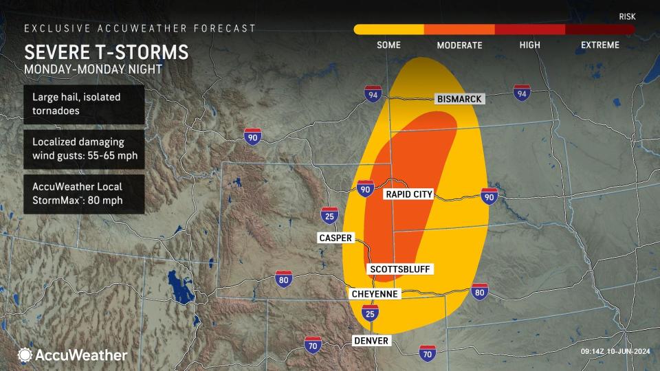
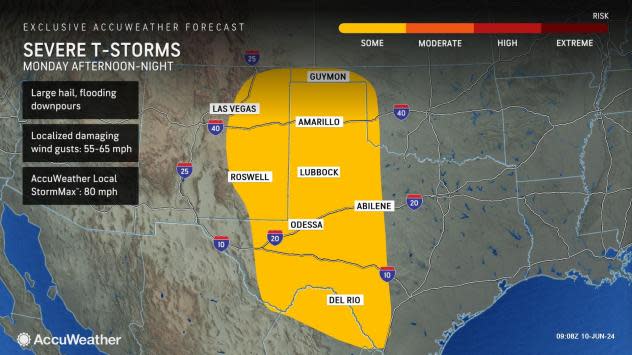
On Monday, strong to severe storms are projected to redevelop across the south-central states. Forecasters are highlighting hazards ranging from large hail and gusty winds to flooding downpours.
The AccuWeather Local StormMax™ for damaging winds is currently set at 80 mph for Monday across western Oklahoma, western Texas to eastern New Mexico.
Farther north into eastern Colorado and the central Plains, there will be a primary risk area for severe weather on Monday. Gusty winds are expected to kick up east of the Colorado Rockies as storms develop, along with the threat for large hail and even isolated tornadoes. Storms will shift eastward into Monday night, covering areas of the Dakotas and Nebraska.
 |
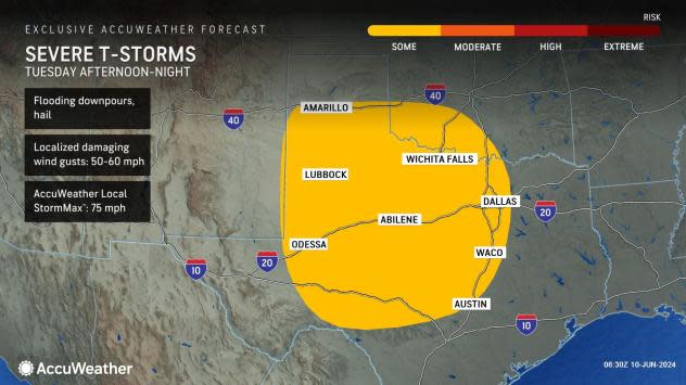
Into the day on Tuesday, the risk for severe thunderstorms will shift east and target the southern Plains, focusing across much of Texas. Once again, large hail, damaging wind gusts and torrential downpours will be the main concern.
 |
Want next-level safety, ad-free? Unlock advanced, hyperlocal severe weather alerts when you subscribe to Premium+ on the AccuWeather app. AccuWeather Alerts™ are prompted by our expert meteorologists who monitor and analyze dangerous weather risks 24/7 to keep you and your family safer.
