
 Yahoo News
 Severe storms charging to the Atlantic coast
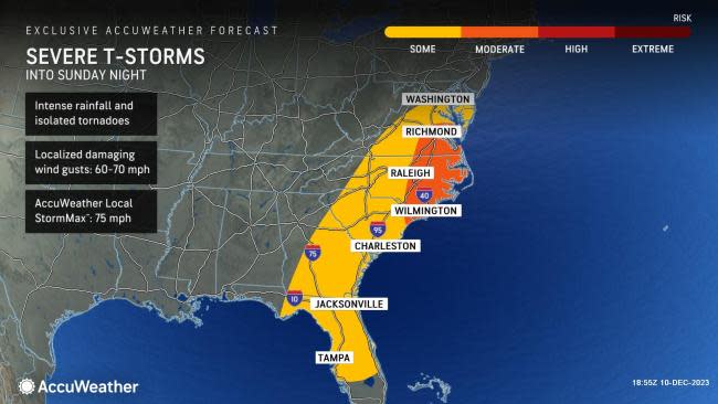

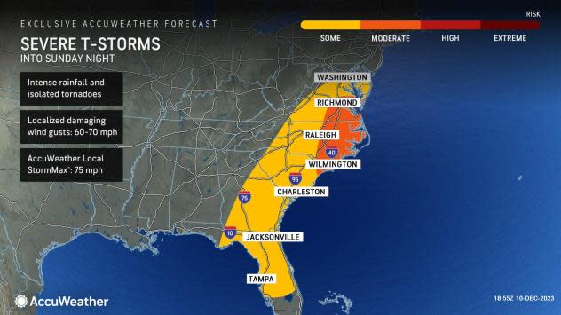
Thunderstorms will erupt once again as a strengthening storm system triggers severe weather that could threaten lives and property, and AccuWeather meteorologists warn that these damaging storms are likely along much of the Atlantic Seaboard on Sunday and Sunday night.
By Saturday afternoon, tornado watches were already put in place across a swath of southeastern Arkansas, northern Mississppi, western Tennessee into Kentucky. A tornado warning was issued shortly before noon CST, warning of a "confirmed large and extremely dangerous tornado" near the town of Dresden and moving to the northeast.
Storm reports across western Tennessee listed that the storm caused damage to trees and power lines along with structural damage to the National Guard Armory and a fire station. By early Saturday afternoon, three preliminary tornado reports were sent in from Stewart and Montgomery counties in Tennessee.
Later Saturday afternoon, the cluster of rotating storms continued into north-central Tennessee, prompting additional tornado warnings, including in the Nashville area, where pictures and video emerged on social media depicting a large, destructive tornado. From Saturday afternoon through Saturday night, there were roughly 25 preliminary tornado reports across Mississippi, Tennessee, Alabama and Florida.
 |
The line of heavy rain associated with these storms will align with a cold front and advance eastward across the central and southern Appalachians and northeastern Gulf coast on Sunday morning and midday before reaching the Eastern Seaboard Sunday evening and night. High winds will accompany and precede the rain. However, not all locations may experience thunder and lightning as the storms grind eastward toward the sea.
Heavy rain, high winds and poor visibility will make for major travel disruptions in the major hubs of Atlanta, Pittsburgh, Charlotte, Washington, D.C., Philadelphia, New York City and Boston. Ground stops and flight delays are likely.
By Sunday afternoon, tornado watches expanded across parts of North Carolina into southeast Virginia. Tornado warnings were issued for locations around Raleigh and locations to the northeast of the city around 1 pm EST on Sunday with reports of downed trees and damage to traffic lights.
Forecasters warn that tornadoes can erupt after dark across northeastern South Carolina and eastern North Carolina on Sunday. Residents are urged to have electronic devices fully charged in order to be alerted of any emergency watches and warnings given the elevated risk for robust storms at night.
 |
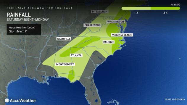
As this widespread storm system pushes to the Atlantic coast, rainfall totals from Saturday night to Monday will generally range from 1-2 inches across parts of central Mississippi, Alabama, Georgia, eastern Tennessee, the Carolinas into the Northeast. Rainfall amounts can range from 2-4 inches near the Gulf Coast, areas of the southern Appalachians and from eastern North Carolina on northward to the mid-Atlantic states with the AccuWeather Local StormMax™ of 7 inches.
Typically, severe weather peaks in the central United States and diminishes somewhat upon crossing the Appalachians and reaching the Atlantic coast. However, in this case, the parent storm and cold front will gain strength through Monday as they move along, allowing the risk for additional dangerous weather all the way to the coastline.
Want next-level safety, ad-free? Unlock advanced, hyperlocal severe weather alerts when you subscribe to Premium+ on the AccuWeather app. AccuWeather Alerts™ are prompted by our expert meteorologists who monitor and analyze dangerous weather risks 24/7 to keep you and your family safer.
