
 Yahoo News
 Snowfall, Arctic air to bring widespread dose of winter from Washington to Dakotas


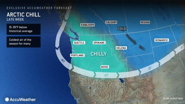
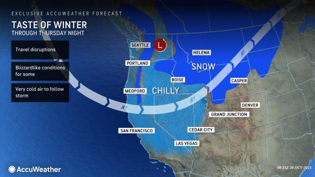


The first true outbreak of Arctic air in the United States will accompany the first far-reaching heavy snowfall of the season from the northern Cascades to the northern Rockies and northern Plains into Thursday night. AccuWeather meteorologists say that additional rounds of snow will follow and may eventually lead to the first episodes of accumulating snow and ice farther south in the Rockies and Plains and perhaps farther east in the Midwest.
The waves of accumulating snow can snarl travel along the Rockies and adjacent areas of the Plains for much of the balance of this week. Strong winds will accompany the snowfall across parts of Montana, northern Wyoming and North Dakota, causing poor visibility and dangerous and difficult roadway conditions.
 |
An area of high pressure that originated in the Arctic has plunged southward across the region, providing the cold air to support snow, and moisture from the Pacific Ocean and Gulf of Mexico will add the necessary fuel.
The same setup brought plunging temperatures, accumulating snow and a rapid freeze-up to the major cities of Calgary and Edmonton, Alberta, from Monday to Tuesday.
Motorists venturing over the Cascade passes should be prepared for early-winter weather with road conditions ranging from wet to slushy to snow-covered. Over the higher terrain in the Washington and Oregon Cascades, 6-12 inches of snow will likely accumulate by Friday morning.
 |
Farther to the east, light snow showers are possible over the Blue Mountains in northeastern Oregon early Thursday.
The air will trend drastically colder farther to the east in much of Idaho, Montana, North Dakota and northern Wyoming to allow much more substantial snow to fall, even down to the valley floors and over the High Plains to the east of the Rockies through Thursday.
"The snow from Montana into North Dakota can come in two rounds in some locations," AccuWeather Senior Meteorologist Adam Douty said.
The first batch of snow began in the area in earnest Tuesday and persisted through Wednesday evening.
The second, heavier round developed on Wednesday night and will wind down later Thursday night. That second burst of snow will fall a bit farther south than the first and may dip as far to the south as northern Utah, western and northern Wyoming and northwestern South Dakota. This snow is also likely to reach across part of northern Minnesota.
 |
"Areas of Montana, North Dakota and Idaho that are hit by both rounds of snow are the most likely to get close to or perhaps more than a foot of snow," Douty said.
Temperatures have trended lower compared to late last week when highs were well into the 60s, 70s and 80s F in the region, and the surge of cold air may shock visitors and residents new to the region.
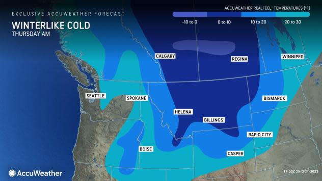
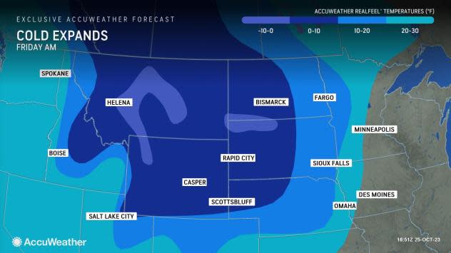
The area is notorious for dramatic swings to cold weather when temperatures can plummet dozens of degrees within hours. Into this weekend, temperatures will tend to drop in stages and are forecast to bottom out on Friday night or Saturday night. During this time, low temperatures in the single digits and below zero from the Rockies to the northern Plains and mainly in the 20s and teens from the western slopes of the Rockies to the Cascades. AccuWeather RealFeel® Temperatures will dip to 10-15 degrees lower than the actual temperatures.
 |
Temperature records are rather low for the area, even for so early in the season. This zone is often one of the first locations to experience Arctic outbreaks during the fall and early winter. However, temperatures will dip close to historically low levels for one or more days during the outbreak.
For example, in Great Falls, Montana, after approaching record-low temperatures set more than 100 years ago in 1919 on Wednesday night, record lows through the rest of October are 5 below zero or lower and will not be challenged during this event. Temperatures are forecast to dip as low as the low single digits in Great Falls late this week and this weekend. As of Wednesday midday, temperatures were hovering in the teens F and AccuWeather RealFeel® Temperatures were mainly in the single digits.
 |
Strong winds often accompany early-season cold blasts, and this outbreak will be no exception. So, as the snow flies, the visibility will drop.
The National Weather Service defines a blizzard as snow or blowing snow that produces sustained winds or gusts of 35 mph or greater and reduces the visibility to 1/4 mile or less for three consecutive hours or more.
"While an all-out blizzard is not expected from this storm, there can still be areas of blowing and drifting snow that can lead to very hazardous travel," Douty said. "In addition to some of the roads in the mountains and passes closing for a time, roads at lower elevations in eastern Montana and western North Dakota may also close for a while."
 |
Plunging temperatures will cause wet and slushy areas to freeze. The combination of snow, Arctic cold and wind may put livestock in the region at risk.
After the snow diminishes Thursday night, yet another round of snow may develop even farther to the south and east this weekend as the colder air makes yet another push. That next round of snow may bring the Denver metro area its first widespread accumulation of the season. Denver averages about 5 inches of snow during October, which tends to fall in one or two events, such as the one that may unfold this weekend.
Snowfall may extend for hundreds of miles from northern Colorado and southeastern Wyoming to areas farther to the east over the central Plains and perhaps to portions of southern Minnesota, Wisconsin and Michigan this weekend. A narrow zone of sleet and freezing rain may develop to the south of the snow zone over the Plains, where the push of cold air is very shallow.
 |
The same progressive pattern and advancing cold air can potentially bring the first round or two of lake-effect snow to portions of the Great Lakes region during the middle to the latter part of next week.
AccuWeather will continue to provide updates on the rounds of snow and advance of cold air.
Want next-level safety, ad-free? Unlock advanced, hyperlocal severe weather alerts when you subscribe to Premium+ on the AccuWeather app. AccuWeather Alerts™ are prompted by our expert meteorologists who monitor and analyze dangerous weather risks 24/7 to keep you and your family safer.
