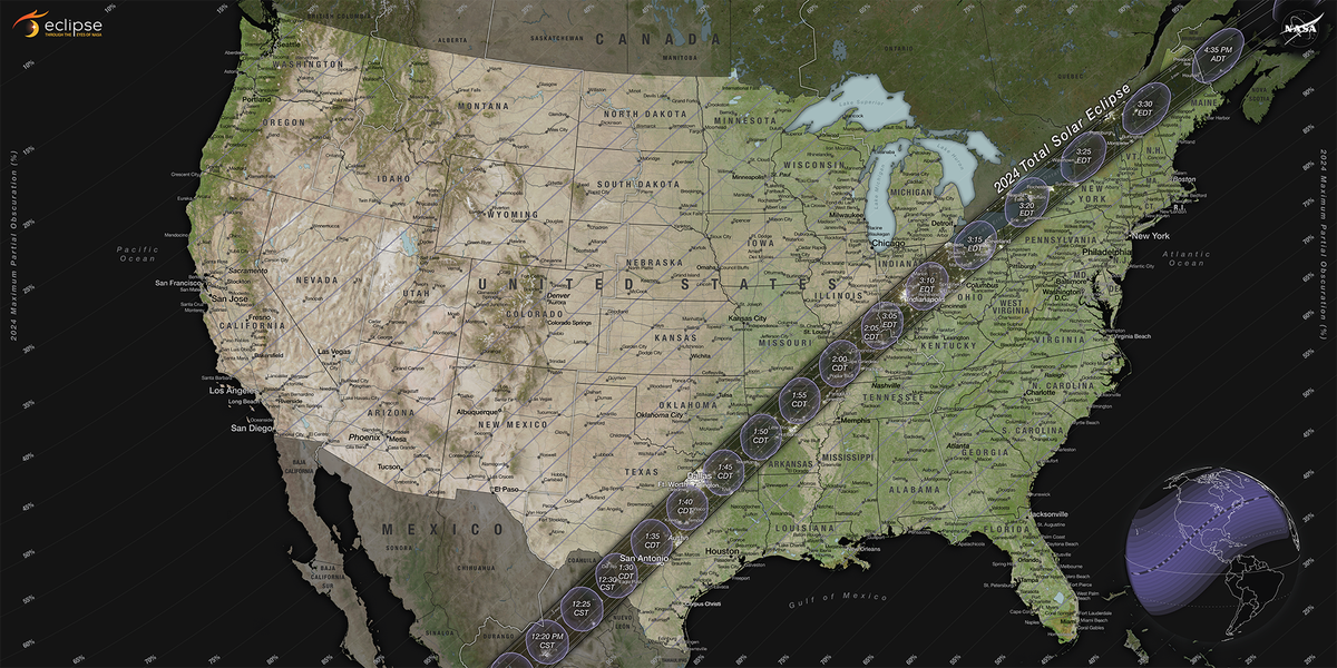
Solar Eclipse 2024: Nasa map shows path of totality

Nasa has released a new map showing the path along the US – stretching from Texas to Maine – from where the total solar eclipse will be visible on 8 April 2024.
The rare cosmic event will be visible across North America, passing over Mexico and Canada, turning the day skies briefly into night.
It will begin over the South Pacific Ocean, and Mexico’s Pacific coast will likely be the first to experience totality at 11.07am PDT on 8 April, weather permitting.
The total solar eclipse will then continue its path from Mexico, entering the US in Texas, traveling through Oklahoma, Arkansas, Missouri, Illinois, Kentucky, Indiana, Ohio, Pennsylvania, New York, Vermont, New Hampshire, and Maine.
Some parts of Tennessee and Michigan will also experience the total eclipse.
Outside these areas, people throughout all the 48 contiguous US states will will have a chance to see a partial solar eclipse, when the moon covers part of the sun, according to Nasa.
The eclipse will then enter Canada in Southern Ontario, and continue through Quebec, New Brunswick, Prince Edward Island, and Cape Breton.
It will exit the continent on the Atlantic coast of Newfoundland, Canada, at 5.16pm NDT.

About 44 million people live inside the 185km-wide (115 mile) path of totality stretching from Mexico to Canada, with 32 million of them in the US.
During a total solar eclipse, the moon lines up perfectly between the Earth and the sun, completely blocking the face of the Sun for a few minutes.
Since in this current event, the moon will make the month’s closest approach to the Earth a day before the eclipse. Totality is expected to last longer to the tune of over seven minutes.
The last time totality lasted longer than seven minutes was in 1973 over Africa and won’t again happen until 2150 over the Pacific.
North America is not expected to see another eclipse again till 2033, and there will not be another eclipse spanning coast-to-coast in the US until 2045.

 Yahoo News
