
 Yahoo News
 There's an ominous meaning behind amazing and 'rare' clouds above Wales
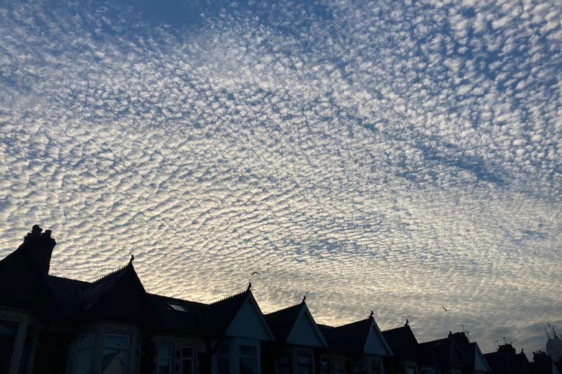
Photos have shown the amazing clouds that formed above parts of south Wales on Tuesday evening, June 25. People from areas of Cardiff and Newport have shared their photos of clouds forming ripples in the blue sky. Some even got to see the beautiful clouds amid the Foo Fighters' epic gig at the Principality Stadium - read our review of the huge gig here.
According to the Met Office however, this kind of cloud formation is relatively "rare". These clouds can be classified as what the forecaster calls cirrocumulus clouds, which form ripples that may resemble honeycomb or the scaly skin of a fish. It is sometimes referred to as a mackerel sky.
Its name derives from Latin, with the 'cirrus' part meaning a lock or tuft of hair, while 'cumulus' means a heap. According to the Met Office, cirrocumulus clouds are made up of lots of small white clouds called cloudlets, which are usually grouped together at high levels, with the height of its base at around 20,000 to 40,000 feet.
READ MORE: Heating expert reveals fan trick that can help to keep your home cool during heatwave
LATEST: 'I tried Shark's new fan and it's the perfect heatwave saviour - and on sale'
It is composed almost entirely from ice crystals. If you look at cirrocumulus clouds, the little cloudlets are regularly spaced. They are usually made up of both ice and 'supercooled' water. According to the Met Office, this means that the water remains as liquid, even at temperatures below 0C. For the latest Welsh news delivered to your inbox sign up to our newsletter.
They form when turbulent vertical currents meet a cirrus layer - cirrus is a form of common cloud that can be seen at any time of the year, with these creating the puffy cumulus shape. You may have seen cirrocumulus clouds but in a slightly different form, as they can also be formed through contrails - the vapour trails left by planes as they fly through a dry upper troposphere.


These streaks can spread out and become cirrus, cirrostratus and cirrocumulus. Perhaps the most interesting detail about these clouds, however, is that they can tell us not only about the weather we have been experiencing recently, but also the potential weather we may experience soon.
According to the Met Office, precipitation from cirrocumulus clouds never reaches the surface, which means that these clouds are usually associated with fair weather. But, their appearance can often prelude storm weather. In other words, it means that you should make the most of the sunny weather while you still can.
According to the Met Office, Wednesday (June 26) is set to be a very warm day with settled conditions at first, but it will turn fresher later in the day. Overall, it will be a "fine and very warm, locally hot, day with plenty of sunshine", with maximum temperature at 27C. In the evening, temperatures will reach 15C.
On Thursday (June 27), the Met Office predicts there will be "lingering light rain and drizzle" but this will soon clear to the east. It will remain a bright and breezy day with a "fresher feel" and perhaps the odd shower later on. The outlook between Friday and Sunday will also be bright and breezy with the occasional shower. The rain and drizzle will arrive on Saturday, but it will turn drier and brighter again on Sunday.
