
 Yahoo News
 Two storms packing snow to collide over Rockies, Plains during Christmas weekend

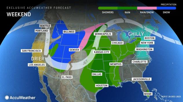

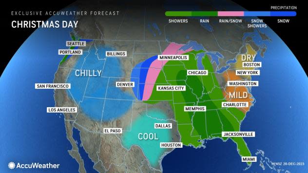
A pair of storms - one that will hit Southern California and the deserts with heavy rain and another in the Northwest with rain and snow - will merge near the middle of the United States and produce a broad zone of rain with heavy snow on the northwestern flank of the storm during the extended Christmas weekend.
"Where the two storms come together, an extended period of accumulating snow is likely, much to the delight of skiers and snow lovers, but more of a nightmare to those traveling," AccuWeather Meteorologist Brandon Buckingham said.
Heavy snow could be one of the biggest impacts from the merging systems, and AccuWeather forecasters will continue to monitor the situation to pinpoint where exactly the worst travel conditions will unfold in the coming days.
 |
"There will be pockets of snow for both the southern Rockies and the interior Northwest prior to the merge from late this week to the start of the Christmas weekend," Buckingham explained.
One hurdle that the two storms will have is the lack of cold air over the Western and Central states. Because of this, snow levels will be high and not down to the valley floors, where the most heavily traveled roads are located.
 |
Initially, some rain will fall on cities such as Boise, Idaho; Flagstaff, Arizona; and Salt Lake City at the end of the week.
"Although it will be great for ski resorts over the northern Rockies and part of the Intermountain West, it may prove to be difficult for some travelers to actually get to the resorts over the higher elevations amid the expected snowy conditions," Buckingham said. "Bigger problems may await travelers over lower elevations and especially those farther to the east."
As the storms gradually begin to merge during the weekend, the atmosphere will cool over the interior West, and snow will work its way down from the ridges and peaks to the intermediate elevations, with a mixture of snow and rain possible on some of the valley floors from Idaho to Utah and northern Arizona. A few inches of snow may accumulate on the mountains of central and northern Arizona this weekend after some rain starts.
Farther to the east, the snow situation is complex and dependent on the exact speed with which the two separate storms fuse into one, as the pace of the merge will determine how quickly the air turns cold enough for snow versus rain or a rain and snow mix outside of the Rockies.
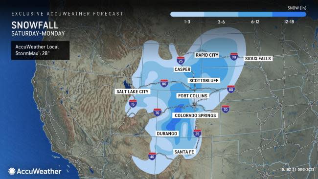
Later during the extended weekend, a belt of heavy snow may cross several major Interstate highways in Colorado, Wyoming, Nebraska and the Dakotas, spanning Saturday to Monday.
"The forecast around Denver is tricky, as there may still be enough of a gap between the two storms to prevent much more than a few inches of snow from Saturday night and Sunday to Christmas Day," Buckingham said.
 |
On the other hand, a quickly merging and strengthening storm could throw heavy snow back toward Denver during the weekend.
The most likely zone for heavy snow, where at least several inches or more may accumulate, is from the Colorado Rockies through southeastern Wyoming, southwestern South Dakota and northwestern Nebraska from Saturday to Sunday night.
 |
"A boost in the snowpack is in store during the final days leading up to the Christmas holiday across portions of the northern Rockies, Yellowstone National Park and the Grand Tetons," Buckingham said.
A large and strengthening storm is likely to continue bringing snow to parts of the central Rockies and adjacent High Plains on Christmas Day and allow it to extend farther to the east in Nebraska, South Dakota and Kansas.
 |
Denver is running close to normal for snow so far this season, with 11.8 inches since Oct. 1 compared to the historical average of 14.8 inches. Salt Lake City, on the other hand, has had just under 4 inches of snow so far, compared to the historical average of 14.2 inches through Dec. 18.
Cheyenne, Wyoming, has had about the same percentage amount of snow versus the historical average, with 14.3 inches versus 18.5 inches.
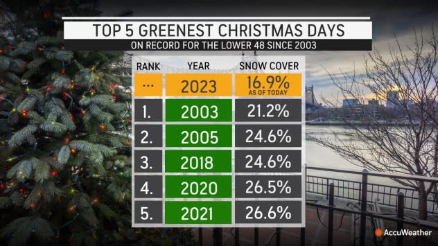
A few locations farther to the east in the lower 48 states have hit their average snow for the season. Montpelier, Vermont, and Sault Ste. Marie, Michigan, have had 23 and 36 inches of snow, respectively. Still, many are well under the historical average, and a "green" Christmas looms.
 |
One spot in the U.S., outside of the lower 48, that has done extremely well in the snow department during the cold weather season is southern Alaska. Anchorage has received a whopping 70.3 inches of snow compared to the historical average of 29.1 inches from Oct. 1 to Dec. 18, and more snow is on the way into the end of the month. Snow has also been plentiful in Fairbanks, Alaska, with 38.4 inches versus the season-to-date average of 27.1 inches.
The main reason for the bumper crop of snow in part of Alaska has been an active jet stream from northeastern Asia through the northern fringe of the Pacific Ocean.
AccuWeather will continue to provide updates on the impending storms for the interior West, Mississippi Valley and conditions elsewhere as the Christmas holiday approaches.
Want next-level safety, ad-free? Unlock advanced, hyperlocal severe weather alerts when you subscribe to Premium+ on the AccuWeather app. AccuWeather Alerts™ are prompted by our expert meteorologists who monitor and analyze dangerous weather risks 24/7 to keep you and your family safer.
