
 Yahoo News
 UK to experience 29C temperatures as North African heatwave hits

The latest weather maps reveal when the UK is expected to bask in its first 29C heatwave of the year. Despite a gloomy and unusually cold start to summer, things might be about to heat up.
Netweather.tv forecasters suggest that all hope is not lost, even though the longest day of the year is just five days away - signalling the gradual return of darker evenings. With peak temperatures barely exceeding 25C, there has been no sign of sustained hot weather hitting the UK. However, a North African plume could hit the country before the end of the month.
This heatwave is predicted to arrive via Europe with a sting in its tail - with June 29 being the second last day a red highlight covers the country, indicating a rise in temperatures. Northern France will experience a sizzling 31C, losing at least two degrees as it crosses the Channel to Britain. The southern coast of England is expected to record the highest temperature, with parts of Sussex set to endure scorching highs of 29C, reports the Express.
READ MORE: The Bristol church which has not seen worship in 40 years
READ MORE: How iconic Weston-super-Mare Grand Pier has survived 120 years
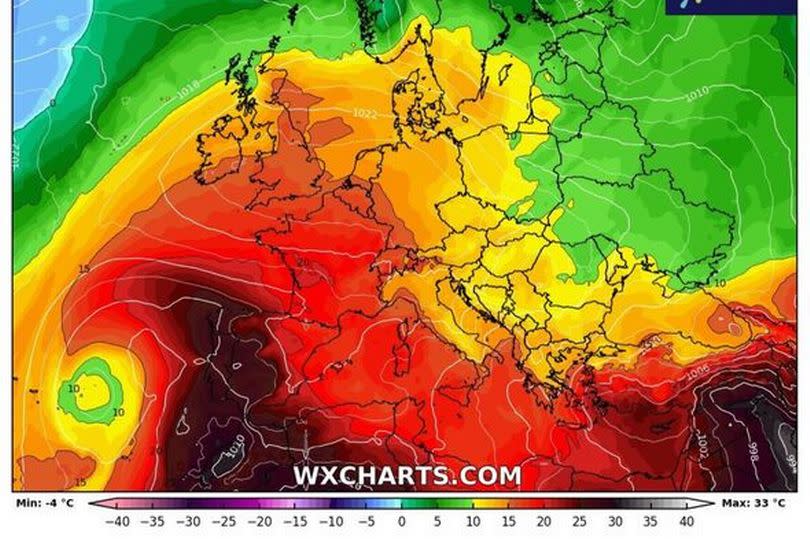
However, other regions of the country won't be far behind. Counties such as Kent, Essex, Hertfordshire, Cambridgeshire, Greater London, Surrey, and Berkshire are due to experience highs of 28C.
Birmingham and other areas of the West Midlands will swelter in highs of 27C, while Manchester and Liverpool are likely to see 26C. Temperatures will drop further north, with towns and cities near Newcastle experiencing 22C.
Cardiff in Wales is expected to experience a moderate 25C. Despite early positive indicators from weather maps, Netweather forecasters stress that this is not a guarantee.
Forecaster Ian Simpson stated: "There is some chance of some of that North African and southern European heat making its way to the British Isles towards the end of June, depending on whether the ridges of high pressure from the Azores align in such a way that we pull in hot air masses from the south and south-east, but this is not a certainty."
As for how long this will last? Jet streams are never too far away, and there is likely to be a "pattern shift" which will nudge thermometers up slightly as the month goes on.
"Predominantly west to south-westerly winds and ridges of high pressure [will be] moving in from the Azores at times, interspersed with periods of more unsettled weather with low-pressure systems coming in off the North Atlantic," Ian added.
The Met Office's long-range forecast doesn't hint at a heatwave, but it does suggest temperatures are set to rise. Up until June 29 it states: " Into the last week of June, changeable conditions are likely, with the focus for these conditions being across the north and west, with spells of more settled and drier conditions likely in the south and east. Nationwide, temperatures are expected to be close to or slightly above average."
Want the latest Bristol breaking news and top stories first? Click here to join our WhatsApp group. We also treat our community members to special offers, promotions, and adverts from us and our partners. If you don’t like our community, you can check out any time you like. If you’re curious, you can read our Privacy Notice.
