
 Yahoo News
 UK flood warnings – latest: Environment agency issue 34 alerts as Wales hit by downpours
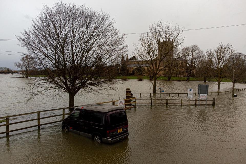
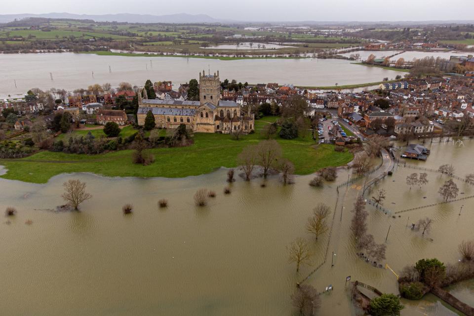
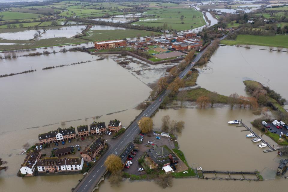
Swathes of England have been almost entirely cut off by flooding after heavy downpours left towns and other residential areas under several feet of water.
Images and videos have captured how settlements across the southwest have been effectively transformed into islands after the River Severn burst its banks following days of torrential rain.
Residents in parts of Tewkesbury, Gloucestershire, have been left marooned by the water, with similar scenes reported across neighbouring Worcester, where Worcester Racecourse and Worcestershire County Council Cricket ground remain submerged.
It comes after the Met Office issued yellow weather warnings for rain and wind across parts of the country until Thursday.
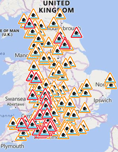
It joins 34 flood warnings and 98 flood alerts from the Environment Agency in place across England.
In a statement, the agency said: “River and surface water flooding impacts are also possible across parts of the North of England on Saturday and Sunday.
“Local groundwater flooding is possible through the next five days in the south of England.”
Key Points
Town almost completely cut off by flood water amid heavy downpours
Yellow warning of rain issued for southwest England and Wales
98 flood alerts in place across England
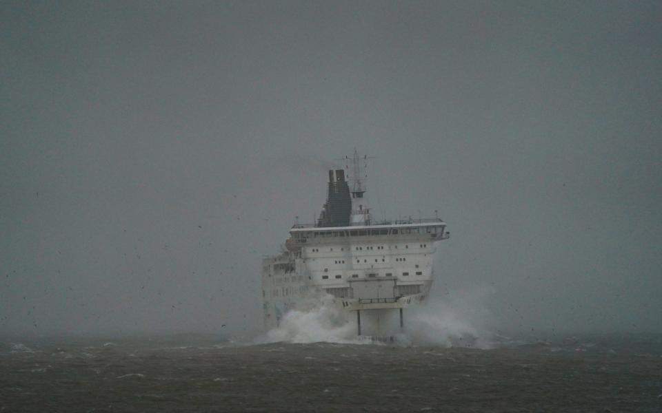
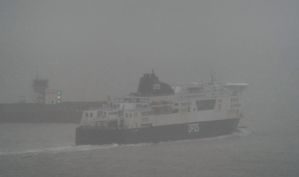
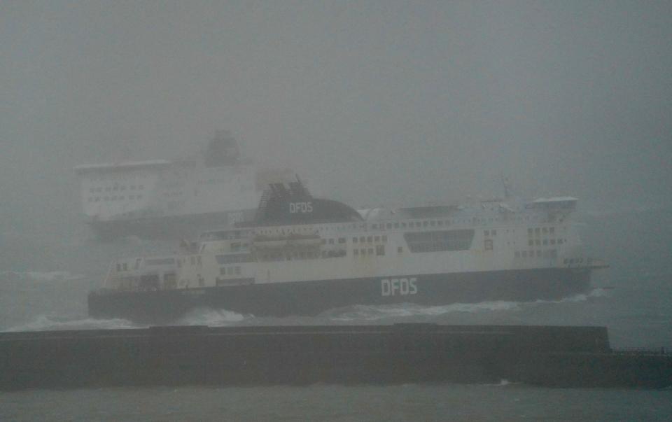
12:39 , Sukhmani Sethi
12:25 , Sukhmani Sethi
A DFDS ferry makes its way through choppy waters as it leaves Port of Dover in Kent during rough weather as rain and strong winds continue.
The major ferry port also faces coastal gales, as well as heavy rain.
11:46 , Sukhmani Sethi
The Met Office forecasts that things should be looking a little drier and brighter in southern parts of the UK this afternoon, as rain and clouds gradually clear away.
⛅ An improving picture for southern areas this afternoon as rain and cloud gradually clears away
☔ But showers and longer periods of rain will continue pushing into western Scotland and Northern Ireland, with gales developing as well pic.twitter.com/h9nKQXyVMO— Met Office (@metoffice) January 12, 2023
11:33 , Sukhmani Sethi
A mountain road in Wales has turned into a waterfall after being battered by torrential rain.
The Bwlch Mountain road was closed following the landslide in Nantymoel this morning which resulted in rocks and heavy rainwater rushing over the mountain.
11:22 , Sukhmani Sethi
The Met Office has issued several yellow warnings from today at 3pm to Friday, which are expected to be lifted on Friday at 3am.
Strong winds are forecast to increase from the west during this afternoon, with gusts up to 55mph affecting coasts of northwest England and northwest Wales moving across all areas through the early hours of Friday morning.
Some heavy showers are likely, making for some difficult travelling conditions. Large waves could be an additional hazard.
⚠️ Yellow weather warning issued ⚠️
Wind across Northern Ireland, plus northwest Wales and England
Thursday 1500 – Friday 0300
Latest info 👉 https://t.co/QwDLMfRBfs
Stay #WeatherAware⚠️ pic.twitter.com/JtaVnXkthu— Met Office (@metoffice) January 12, 2023
10:41 , Sukhmani Sethi
Cllr Andrew Morgan, from Rhondda Cynon Taff in Wales, has reported flooding in “several places” across the borough.
Culverts upgraded by the council held last night against the heavy rainfall, accoording to the councillor, but has conceded that works over “several years” are still needed.
While it appears all the culverts upgraded by RCT council since Storm Dennis in 2020 have held overnight, we have said there are many more to do and several more years work planned.
There is unfortunately flooding in several places across RCT including some properties today pic.twitter.com/bb65q6l8U5— Cllr Andrew Morgan OBE (@AndrewMorganRCT) January 12, 2023
Heavy rain gushes through wall of Welsh village
09:55 , Maryam Zakir-Hussain
Heavy rain gushes though a wall in a small Welsh village Blaenllechau as rainwater runs down roads.
Wall looks like it’s going to collapse in Blaenllechau @RCTCouncil pic.twitter.com/oeVknBZ4zJ
— Kayleigh Crotty (@kayleighcrotty1) January 12, 2023
Regions and areas affected by yellow weather warning
09:35 , Maryam Zakir-Hussain
A yellow weather warning is in place until 5pm on Thursday as heavy downpours and strong winds batter parts of Wales and southwest England. Here are the regions impacted:
South West England
Bath and North East Somerset
Bristol
Cornwall
Devon
Dorset
North Somerset
Plymouth
Somerset
South Gloucestershire
Torbay
Wiltshire
Wales
Blaenau Gwent
Bridgend
Caerphilly
Cardiff
Carmarthenshire
Ceredigion
Merthyr Tydfil
Monmouthshire
Neath Port Talbot
Newport
Pembrokeshire
Powys
Rhondda Cynon Taf
Swansea
Torfaen
Vale of Glamorgan
West Midlands
Herefordshire
Shropshire
Yellow weather warning in place on Thursday across parts of Wales and southwest England
09:05 , Maryam Zakir-Hussain
The Met Office has issued a yellow weather warning across parts of Wales and southwest England as heavy downpours overnight cause flooding and widespread disruption.
The warning lasts until 5pm today as persistent heavy rain continues to pour down.
Strong winds of upto 60mph are also in store while the worst affection areas of Brecon Beacons and Exmoor could see 60-80mm of rainfall.
The weather service warned that power cuts and loss of other services to some homes and businesses are possible as well as disruption to travel.
Environment Agency issues 44 flood warnings where flooding is expected
08:22 , Maryam Zakir-Hussain
There are 44 flood warning warnings where flooding is expected across England.
According to the Environment Agency, local groundwater flooding is possible through the next five days in the south of England.
Land, roads and some properties could flood and there could be travel disruption.
Heavy rain and gale to continue through Thursday morning
07:49 , Maryam Zakir-Hussain
Heavy rain will be focused across Wales and southwest England, the Met Office tweeted, with strong winds on some southern and western coasts.
🌧️ Thursday morning will start cold and bright in parts of Scotland, but it'll be wetter and milder elsewhere with the heaviest rain focused across Wales and southwest England
🌬️ Windy again with gales on some southern and western coasts, however lighter winds in the north pic.twitter.com/pdZ3eQyqgG— Met Office (@metoffice) January 11, 2023
Watch: High water levels seen along swollen Worcestershire river as flood warnings issued
07:00 , Emily Atkinson
UK weather: Flood warnings issued across Britain as country braces for heavy rain - watch
06:00 , Emily Atkinson

UK weather: Flood warnings issued across Britain as country braces for heavy rain
Watch: Floodwater surrounds Gloucestershire's Tewkesbury Abbey in stunning drone footage
05:00 , Emily Atkinson
Winter temperature records broken across Europe just days into 2023
04:00 , Emily Atkinson
Winter temperatures have hit record highs across Europe already this month, as conditions have warmed up following December’s cold snap.
Eight countries have seen record national highs, with regional records in another three areas.
The start of the new year in Warsaw, Poland hit 18.9C on Sunday while it was 25.1C in Bilbao, Spain, the latter of which is 10C warmer than average for the time of year.
Lucy Skoulding reports:
Winter temperature records broken across Europe just days into 2023
How to check for flood alerts and warnings in your area
03:00 , Emily Atkinson
A number of new flood warnings have been issued in recent days as a band of rainwater and strong gales pushed eastwards across England and Wales, further threatening to disrupt travel after a month of rail and road strikes.
The Met Office has issued a new yellow weather warning of heavy rain for northwest England and central Wales on Tuesday, saying that between 60 and 80mm could fall between 6am and 8pm and warning of possible flooding.
If you are seeking to get ahead of the weather this winter, you can check all the latest flood alerts and warnings in your area on the government’s website simply by entering your postcode here.
Joe Sommerlad has more:

How to check for flood alerts and warnings in your area
Met Office five day outlook
02:00 , Emily Atkinson
Wednesday evening and night:
Rain moving eastwards across Northern Ireland, Wales, and England, heavy at times with a risk of flooding in the west. Windy in the south with coastal gales. Showers across Scotland dying out, leaving clearing skies and a patchy frost.
Thursday:
Further rain moving eastwards, heavy in places. Turning brighter from the west but with blustery showers, frequent and heavy in the northwest where gales or severe gales are likely.
Outlook for Friday to Sunday:
Remaining unsettled with further spells of rain and strong winds. Mostly mild at first, but turning somewhat colder through the weekend.
Heavy rain and flood warnings as downpours to lash England and Wales for 20 hours
01:00 , Emily Atkinson
England and Wales are set to be lashed by persistent heavy rain, with three days of warnings issued by the Met Office.
Scores of flood warnings and alerts are already in place for large parts of the country, with more downpours on the way this week.
Yellow weather warnings are already in place for north west England and parts of Wales and Scotland until 8pm on Monday.
My colleague Daniel Reast reports:

Flood warnings as England and Wales to be lashed by heavy rain for 20 hours
Watch: Cricket grounds completely submerged by floodwater after heavy downpour
00:00 , Emily Atkinson
How to assemble your own flood kit
Wednesday 11 January 2023 23:00 , Emily Atkinson
If #flooding is predicted in your area, you may want to consider assembling a #floodkit 👜
The kit includes key items that will help minimise the risks if flooding means you need to leave your home quickly. 🌧️
Read our list of suggested flood kit items 👇https://t.co/JiuKFaIFwf pic.twitter.com/MKRPYsgwQl— Cyfoeth Naturiol Cymru | Natural Resources Wales (@NatResWales) January 11, 2023
In pictures: Flood waters around Tewkesbury
Wednesday 11 January 2023 22:00 , Emily Atkinson

Temperatures to dip at weekend
Wednesday 11 January 2023 21:00 , Emily Atkinson
The Met Office says temperatures will dip through the weekend and into next week, with the jet stream one of the driving forces behind this change.
Speaking in the Met Office 10-Day Trend, Meteorologist and Presenter Aidan McGivern said: “Next week, the jet stream is a bit more amplified and it’s coming at the UK from the northwest rather than from the west like recent days. This subtle change into the start of next week will see colder weather coming in and rather than prolonged bouts of rain from the west, we’re likely to see rain and showers coming from the northwest.
“These showers from the north could fall as snow over the high parts of Scotland, northern England and Northern Ireland later in the weekend, and as we move through next week often below average temperatures could support a mixture of rain, hail sleet and snow. Most of any snow accumulation is likely over higher parts of the northern UK.
“However, at this point significant differences in the computer models emerge. Most solutions lead to some unsettled weather, but the distribution of the rainfall and where we’re likely to see any snow varies as well. On Tuesday next week, the greatest risk of snow will be across northern parts of the UK, perhaps central areas and mostly over the hills.”
Brecon Beacons and Exmoor to experience wettest weather, say forecasters
Wednesday 11 January 2023 20:00 , Emily Atkinson
More now from the Met Office 10-Day Trend:
Aidan McGivern continued: “With all that wet weather coming in, there are concerns, particularly for those areas that have already seen so much rain across western England and Wales. The wettest weather is likely to see 60-80mm falling across the Brecon Beacons and Exmoor.”
Further persistent rain will move in on Friday night and into Saturday, with the focus for the heaviest rain likely to be further north, including north Wales, northern England and Scotland, though many areas will still see periods of rain into the weekend
Wet and windy weather to continue into weekend
Wednesday 11 January 2023 18:50 , Emily Atkinson
Wet and windy conditions will continue to dominate as we head towards the weekend, thanks largely to the position of the jet stream, forecasters have said.
Speaking in the Met Office 10-Day Trend, Meteorologist and Presenter Aidan McGivern said: “The jet stream is approaching the UK from the west and sending us further areas of low pressure, with tightly packed isobars across the UK. That continues to be the case as further low-pressure systems deepen and get sent in from the west.
“It’s going to stay blustery, with some strong gusts in the west in particular and these lows will continue to send us outbreaks of rain and showers heading into the weekend.”
Watch: Heavy rain causes flooding and disruption across the UK
Wednesday 11 January 2023 18:20 , Emily Atkinson
98 flood alerts in place across England
Wednesday 11 January 2023 17:50 , Emily Atkinson
There are currently 34 flood warnings and 98 flood alerts in place across England.
The Environment Agency said: “Local river and surface water flooding impacts are probable in parts of South West England and possible in parts of the North and far South of England and the Midlands later Wednesday into Thursday with river flooding impacts continuing into Friday.
“Slower responding rivers, particularly in parts of the West Midlands and North East England, are likely to remain high through the next five days leading to further river flooding impacts.
“River and surface water flooding impacts are also possible across parts of the North of England on Saturday and Sunday.
“Local groundwater flooding is possible through the next five days in the south of England.
“Land, roads, and some properties could flood and there could be travel disruption.”
Drivers urged to ‘take care’ if making car journeys
Wednesday 11 January 2023 17:20 , Emily Atkinson
Drivers have been urged to “take care” if they plan on making journeys by road this evening as the heavy downpours set in for the night.
Posting to Twitter, the Met Office said: “Bands of heavy rain and squally winds continue to move east across many areas this afternoon, with some particularly torrential bursts in central and southern areas.
“Take care if you’re about to make a journey.”
In pictures: Persistent flooding leaves town marooned
Wednesday 11 January 2023 16:50 , Emily Atkinson
Shocking aerial images show how parts of Tewkesbury, Gloucestershire, have been turned effectively into islands as a result of flooding.

How will the rainfall impact my area?
Wednesday 11 January 2023 16:21 , Emily Atkinson
Here is a useful graphic showing how Wednesday and Thursday’s downpours are likely to impact different areas across the UK:
⚠️ A rain warning is in place for tonight and tomorrow covering much of Wales and southwest England
💦 Some higher ground areas may see 70-90 mm or more during this period, bringing the risk of flooding pic.twitter.com/fQokH5YzD1— Met Office (@metoffice) January 11, 2023
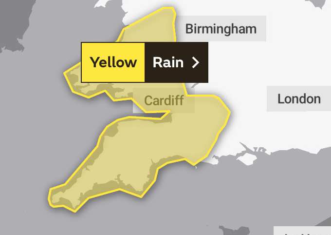
Yellow warning of rain issued for southwest England and Wales
Wednesday 11 January 2023 16:18 , Emily Atkinson
A yellow weather warning will be in place for much of southwest England and parts of Wales from 9pm tonight to 5pm on Thursday.
Here’s what the Met Office say to expect:
Possible power cuts and loss of other services to some homes and businesses
Homes and businesses could be flooded, causing damage to some buildings
Fast flowing or deep floodwater is possible
Delays or cancellations to train and bus services are possible
Spray and flooding could lead to difficult driving conditions and some road closures
Some communities may be cut off by flooded roads
UK weather: Town almost completely cut off by flood water amid heavy downpours
Wednesday 11 January 2023 16:13 , Emily Atkinson
Aerial images show residential areas cut off as heavy downpours caused flooding around the country.
The Met Office has yellow weather warnings for rain and wind in place for Thursday for South West England and Wales as the continuing downpours pose a risk of power cuts and fast-flowing floodwater.
Parts of Tewkesbury, Gloucestershire, were almost completely cut off by flood water after the River Severn burst its banks following days of torrential rain.
My colleague Liam James reports:

Town almost completely cut off by flood water as heavy rain batters UK

