
 Yahoo News
 UK set for heat and sun on weekend but will it last? How hot it will be where you live
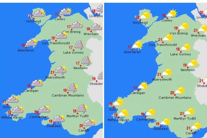
Sunday looks set to be the driest and sunniest day of the weekend in Wales with highs of 21°C. It comes after a mixed week of unsettled weather that has seen heavy showers and spells of sunshine. The Met Office says that Friday is set to be drier and warmer but heavier showers are possible on Saturday.
Friday will start of overcast but forecasts say it will brighten up through the morning with sunny spells, but misty conditions may persist on some coasts in northwest Wales for much of the day. Temperatures will be around 20°C. Temperatures will stay generally mild over night with a minimum temperature of 11 °C, the Met Office forecast for Wales says.
READ MORE: Cardiff city centre getting new hotel replacing well-known businesses
READ MORE: UK's 10 most walkable cities named and Cardiff isn't there at all
Its forecast adds for Saturday: "A mainly cloudy day with bright or sunny intervals. Showers are likely in places, these turning heavy and thundery by the afternoon. Feeling warm in the sunshine. Maximum temperature 21°C." Sunday looks set to be the much better day of the weekend and it will be mainly dry and sunny, and that will remain for Monday before a "chance of showers" again on Tuesday.
Cardiff will be among the hottest places in the UK on Sunday, with temperatures reaching 21°C, as will Carmarthenshire. It will be slightly cooler along the Pembrokeshire and south-west Wales coastline but still warm, sunny and dry. London will hit 22°C, with Manchester also at 21°C.
How Saturday and Sunday look:
The UK long range forecast for the end of May is showing a lot of "uncertainty" as the UK will be "in-between" different areas of pressure. The forecasting agency explains: "The UK will be in-between low pressure over the near continent trying to keep things unsettled and potentially thundery; high pressure to the west or southwest which would settle things down; and finally low pressure to the north or northwest which may being a more climatological split in conditions between the south and north."
Adding: "Overall though, one way or another, it looks like remaining fairly unsettled across much of the UK, with further rain, showers or even thunderstorms in places, though there will be some sunshine between times, the best of this possibly in southwestern parts. Both rainfall amounts and temperatures are likely to be a little above average, but some large spatial differences are likely."
There is also a longer-term forecast for the beginning of June that says: "There is nothing to suggest that conditions will be massively different to climatology at the end of the current month and though the first half of June. That said, both temperatures and rainfall are more-likely to be a little above average overall, with a fairly mixed bag seemingly most probable, with further rain or showers (possibly heavy/thundery at times) but also some spells of warm sunshine when it's not raining."

