
 Yahoo News
 UK set for more heavy showers with more hail and thunder possible
Parts of the UK could see more thunder and hail today, the Met Office has warned. Tuesday's weather forecast says we are in for a drier and less windy than Monday with sunny spells but scattered blustery showers.
It will become mostly dry for Wales and the southwest of England in the afternoon, but will still feel chilly - especially on the east coast.
Writing on X, formerly Twitter, the Met Office said on Tuesday morning: "Another day of sunshine and showers is on the cards today. Some of the showers could be heavy with a small chance of hail and thunder. However, the wind won't be as blustery as yesterday, and the showers will be more scattered"
READ NEXT: Huge police search at beauty spot over torso murder will end today
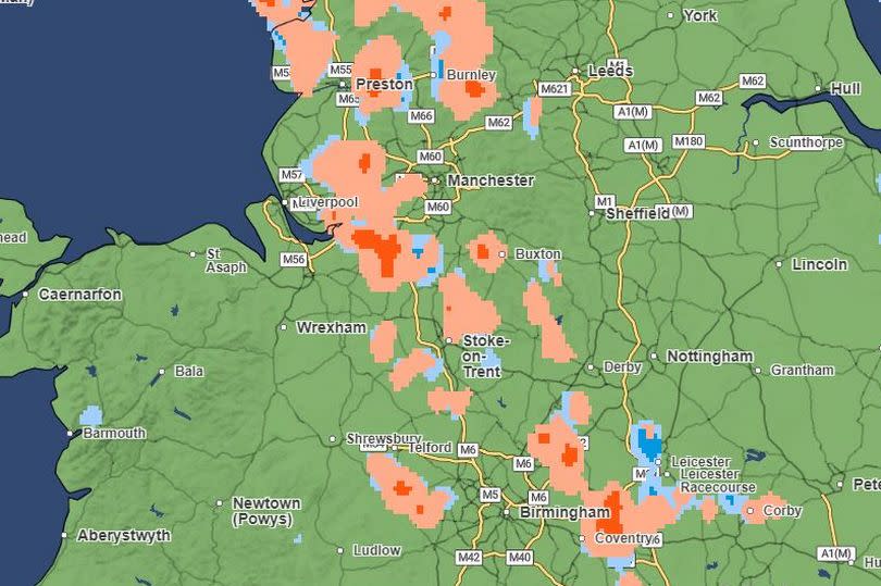
According to the Met Office weather radar, a band of hail is set to move down from the northwest to the southeast throughout the afternoon. Parts of Greater Manchester, Liverpool, London and Birmingham could see heavy hail showers, the map shows.
Tonight is expected to be dry for most, but with some showers returning to Wales and eastern Scotland and parts of the north could wake up to patchy ground frost.
Wednesday is set to be much of the same with sunny spells and scattered showers across the country, with winds light than they have been of late.
It comes after a weather warning for wind was in place for large parts of the country on Monday. In Knutton, near Stoke-on-Trent, a suspected tornado left residents “petrified” when it ripped through the village earlier in the day.
Residents say vehicles, caravans, roofs and chimneys were damaged by the strong winds.
Over the weekend, the Met Office is expecting some high pressure which could lead to drier weather for large parts of the UK.
Mr Dixon said: “By the time we get to the weekend, there’s a signal for higher pressure to build in from the south-west which would settle things down in terms of rainfall totals.
“We’ve obviously seen a very wet few weeks and months indeed for the UK, but by the time we get to Saturday and into Sunday we’re looking at high pressure building in from the west, which would see a reduction in those rainfall totals and some much needed dry weather for some areas.”

