
 Yahoo News
 UK Weather update: Heatwave to return with temperatures soaring in three English regions
UK weather maps have pinpointed the specific date when a surge in heat could see three regions bask in welcoming warmth ahead of an expected heatwave. This past week, Britain was blanketed by rain and cloud, a stark contrast to the 30C highs and unspoiled sunshine from not long ago.
The dip in temperature has been notable with some areas experiencing a considerable cool off, averaging 10C less compared to last week.
The Met Office described this shifting forecast as "unsettled and changeable", underlining that cloudy and rainy conditions would persist in the interim. Nevertheless, recent weather maps signal a potential shift in the coming fortnight, forecasting a resurgence in higher temperatures.
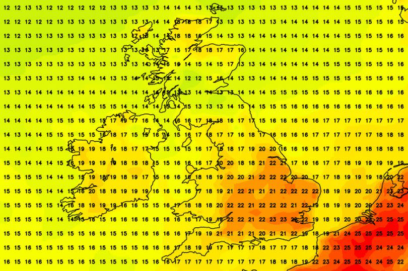
As per the charts provided by the forecasters at Netweather, it is predicted that the heat from late June could be re-emerging early this month, courtesy of our European neighbours. From July 10, the map highlights three specific regions where temperatures will creep into the 20C bracket again, with the southeast feeling the most impact due to conditions from France and beyond.
It is suggested that Eastern England, Southeast England and London could witness temperatures bouncing between 20C and 23C around this time, with the warm spell set to hang around for a few days following. Maps outlining the weather for July 16 indicate that the mercury may stay settled in the 20C range, predominantly in southeastern England, where it's estimated the highs could remain at 21C, reports the Mirror.
The Met Office's long-range forecast, which covers the period from July 8 to 17, paints a similar picture. It suggests that the recent gloomy weather will make way for typical July temperatures.
The forecast reads: "The unsettled and changeable theme is expected to continue through the majority of this period."
"Cloud and rain-bearing systems will cross the UK from the west or southwest at times, accompanied by periods of stronger winds, but there are likely to be drier interludes too, with the best of the more settled weather in the east. With a generally southerly wind direction, temperatures are expected to rise back to the July norm from the cool beginning to the week, with the potential for wafts of warm continental air to affect the southeast at times."
The forecast concludes: "Into the second week, there are tentative signs that conditions could gradually become a bit more settled, though temperatures are likely to remain around average overall."

