
 Yahoo News
 UK weather maps turn red hot as new heatwave to hit in just days - and it'll last a while
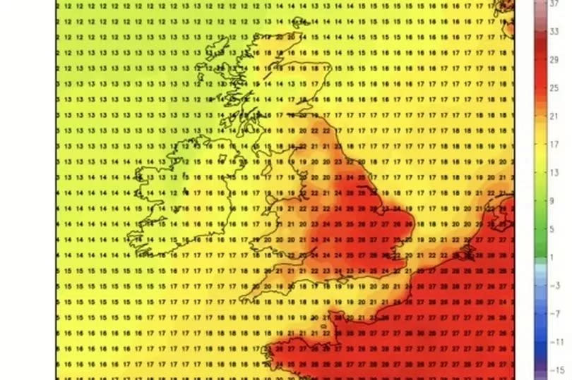
Weather maps are turning a scorching shade of red as forecasters predict another heatwave for the UK next month.
Brits can expect a return of sweltering temperatures as a subtropical Mediterranean airstream is set to bring in another warm spell, with thermometers potentially soaring close to 30C once again. This comes after many enjoyed a splendid sunny period this week, which saw beaches and parks brimming with sun-seekers.
According to Netweather's latest weather maps, the upcoming heatwave is expected to reach its peak on Sunday, July 14, with Greater London and surrounding areas likely to experience the highest temperatures, around 30C. Early predictions also indicate that parts of Southwest England will see mercury levels climbing above 25C.
READ MORE: I found a 'magical' hidden oasis between the M5 and M6 and could spend all day there
Get breaking news on BirminghamLive WhatsApp, click the link to join
However, since Wednesday's scorcher, the weather has been quite changeable across the UK. The Scottish Highlands were drenched with more than 40mm (1.6 inches) of rain on Friday, while North Yorkshire also experienced heavy downpours.
Showers are anticipated to continue into Sunday, especially in regions of the Midlands, reports the Mirror. Despite these hot forecasts, the Met Office's long-range outlook suggests a quick alternation between wet and dry conditions. For the latter half of July, the Met Office's prediction leans towards variability, stating: "On balance most likely rather changeable at first, with periods of unsettled and cloudy, wet weather mixed with spells of dry and fine weather, with weather systems tending to come from the west."
"This means that the west is likely to see the wettest conditions, while the east will tend to be drier. By mid-month, there is a signal for more settled conditions to develop, so more in the way of dry weather, although still with a risk of some rain/showers at times. Temperatures close to average at first, but with a greater chance of warmer than average conditions later in the period."

