
 Yahoo News
 UK weather: New warning for ice issued by Met Office as blizzard conditions to sweep in
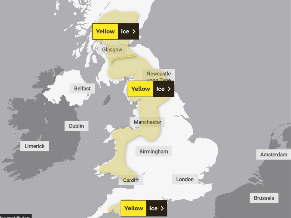
New weather warnings for ice have been issued by the Met Office across swathes of the UK today as snowy conditions and blizzards threaten to sweep across the country.
A yellow weather warning for the south west was issued shortly before 6am on Saturday, joining two more alerts for extreme conditions today across the north west and parts of Scotland.
Residents in the south west were warned of “icy surfaces causing difficult travel conditions in a few places” – caused by likely “icy patches on some untreated roads, pavements and cycle paths.”
The Met Office cautions that the wintry conditions could also lead to some injuries from slips and falls on icy surfaces. The new warning is in place until 11am but other alerts for snow and ice continue until late on Sunday.
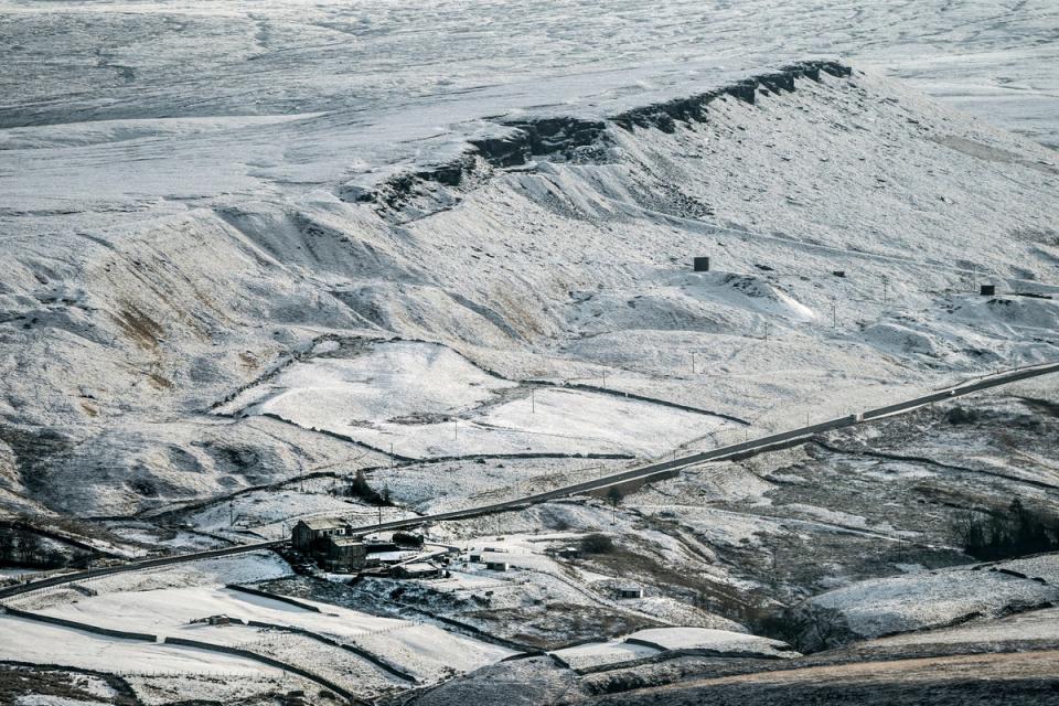
Across swathes of the north west and Wales, showery rain and sleet is expected to lead to a weekend washout in some parts. Though some snow is likely, mainly over hills, it will lead to an ice risk this morning, and possible travel disruption.
Elsewhere, earlier snowfall in southern and central Scotland is set to freeze today, leading to widespread icy conditions overnight and early Saturday and likely continued travel disruption.
A level three cold weather alert was earlier issued by the UK Health Security Agency (UKHSA) for all of England until midnight on Sunday, which it warns could “increase the health risks to vulnerable patients and disrupt the delivery of services”.
Forecasters say temperatures could temporarily rise on Sunday but this will bring strong winds leading to snow, blizzards and ice and freezing rain, creating hazardous conditions on the roads.
Met Office deputy chief forecaster Helen Caughey said: “The northerly airflow and cold conditions which have dominated our weather patterns over the last 10 days will start to lose ground to a push of mild air from the south-west on Sunday.
“As the mild air meets the cold air currently in situ over the UK there will be a transient spell of snow, potentially to low levels, especially in the north.
“Add to this the risk of rain falling onto frozen surfaces, and strong winds over upland areas of northern Britain, bringing blizzard conditions, and this could be a day to avoid travelling in some areas, although the snow should turn to rain later.
Mild air will arrive this weekend, but it could also bring a spell of snow ❄️
Alex has all the details for Sunday's snowfall
Keep up to date with the forecast on our app 👇 https://t.co/SKPrqORHEO pic.twitter.com/yBm3U4l7uS— Met Office (@metoffice) December 16, 2022
“There is also a brief risk of a period of freezing rain most likely to impact areas from the Pennines northwards, which could result in some power interruptions.”
Cold temperatures are likely to make a return next week, Ms Caughey said, but insisted it was too early to gauge if a white Christmas was on the way.
She said: “It will remain unsettled next week. Strong winds could prove disruptive at times, especially through the first half of the week, and there is the possibility of some persistent rain for parts of the South West.
“Although not as cold as we are currently experiencing, we could potentially see a return of some wintry hazards at times, mainly across higher ground in the north, but there is still a lot of uncertainty in how prolonged this might be and what associated hazards it might bring.
“The unsettled picture for next week means, that although Christmas is just a week away, it is still not possible to say with any certainty if we will have a white Christmas Day or not.”
Peter Jenkins, director of campaigns at Water UK, advised that the rise in temperature could cause burst pipes.
He said: “The recent freezing weather has been very disruptive to many people.
“The last thing we want is for people to experience further disruption as temperatures rise this weekend, putting many homes at risk of burst pipes due to freeze-thaw.

“That’s why we’re urging everyone to check their water pipes are well insulated now and to follow our simple tips to protect homes against weather conditions.
“If you’re concerned about the impact of freeze-thaw or the cold weather, we encourage you to get in touch with your water company for further help and advice.”
It follows a run of travel chaos in Scotland with Police Scotland issuing a travel warning for the whole of the nation advising people to travel with caution as snow conditions affected many roads on Friday.
Air passengers were also affected as the runway at Glasgow Airport was closed during the morning while snow and ice was cleared. It reopened at around 11.30am.
Many schools around the country were shut due to the weather, including some in Aberdeenshire, the Highlands and Perth and Kinross.
In Shetland, engineers have been working to reconnect thousands of homes which lost power on Monday afternoon as heavy snow brought down lines.
Scottish and Southern Electricity Networks (SSEN) Distribution said that as of 1pm on Friday, around 1,600 properties remained without power in parts of Voe, Brae and West Mainland in Shetland.
With additional reporting from PA

