
 Yahoo News
 Violent storm to bring repeat of Southern severe weather threat, Eastern flooding and high winds


The second powerhouse storm in less than a week will impact much of the eastern half of the nation into this weekend. For many in the southern and eastern United States, it will seem like a repeat of the dangers and disruptions associated with severe weather, flooding and high winds from the storm from Monday to Tuesday, AccuWeather meteorologists say.
 |
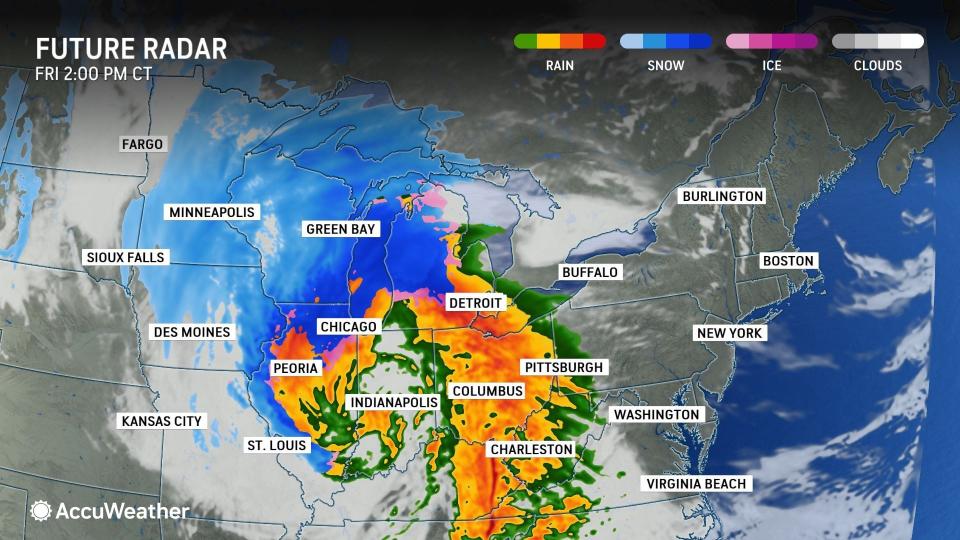
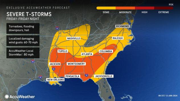
In the area from the Lower Mississippi Valley through the upper Gulf Coast and the southern Atlantic Seaboard, an outbreak of severe weather is in store, including the risk of tornadoes into Friday evening.
Unlike the warm season, when severe thunderstorms and tornadoes highly depend on sunshine and heating of the day, severe weather tends to behave differently in the wintertime. During the cold weather season, a surge of warm and humid air does not necessarily have to be accompanied by sunshine. Instead, a strong jet stream and an associated strong storm system are enough to trigger an outbreak. That was the case early this week and likely will be the case to end the week.
 |
As the parent storm began to strengthen rapidly Thursday night, jet stream energy and a surge of warm and humid air came together and caused an eruption of thunderstorms from southeastern Oklahoma and northeastern Texas to Arkansas and much of northern and western Louisiana. The thunderstorms organized along and ahead of a strengthening cold front.
Into Friday evening, severe thunderstorms will progress eastward with the strong cold front across the Interstate 10 and 20 corridors from Mississippi to the Florida Panhandle, Alabama, Georgia and South Carolina. Many of these storms will continue to produce torrential downpours that can lead to flash flooding, regardless of prior drought conditions. Some storms will also produce strong wind gusts that can knock down trees. A few of the strongest storms will be capable of producing tornadoes.
 |
"Some of the same areas that were struck by severe weather just a few days ago, like Panama City Beach and Marianna, Florida, will once again be at risk for severe thunderstorms, perhaps including tornadoes," AccuWeather Senior Meteorologist Courtney Travis warned.
As of early Friday morning, the crews from the National Weather Service investigating the damage have confirmed that at least 24 tornadoes touched down in the Southern states spanning Jan. 8-9. Some of the tornadoes near the Gulf Coast began as waterspouts.
Some severe thunderstorms cannot be ruled out farther to the north in Tennessee, part of the Ohio Valley and perhaps even the mid-Atlantic coast. The same threats will continue, from flooding downpours to localized damaging wind gusts. However, the potential for a few tornadoes will also exist.
Despite the daylight hours, some of the tornadoes may be obscured by low clouds, drenching rain or hilly terrain -- all of which will add to the danger.
By Friday evening, the severe thunderstorm and tornado threat will shift into the zone from North Carolina to southeastern South Carolina, coastal Georgia and the northern part of the Florida Peninsula.
 |
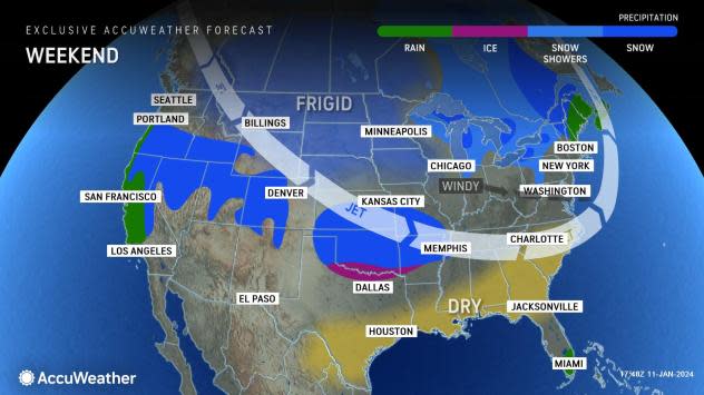
Immediately after the cold front sweeps through the region, the threat of severe thunderstorms will end from west to east on Friday evening as the air dries out and temperatures dip. However, the worst of the storm's impact will just be ramping up in the Northeast.
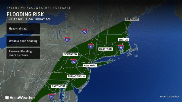
The storm will unleash another 1-2 inches of rain on the Eastern states from Friday to Saturday, with local amounts to 3 inches.
"Even though this rain is roughly about half of what the storm dumped on the region earlier this week, it will not take as much to renew flooding problems and to match or exceed the severity of flooding," Travis said.
 |
Streams are running high, some rivers are still out of their banks and the soil remains saturated from parts of the Southeast to New England. In some cases early this week, small streams and rivers reached record high levels for January, typically a time for low water levels before the spring thaw.
Much of the rain from the storm and cold front will fall in less than eight hours, meaning that the general 1-2 inches of rain will fall at an excessive rate. Small streams and poor drainage areas will rapidly fill with water.
The timing of the heaviest rain from the Carolinas to New York state will be Friday night. In the mid-Atlantic, the big rain and flash flood threat will occur after the evening rush hour.
 |
However, rapidly rising streams and flooded roadways during the overnight hours will add to the danger to motorists.
The heaviest rain will pivot from eastern New York through much of New England from late Friday night to Saturday morning, which may shut down early weekend travel in some areas.
Forecasters urge motorists never to drive through flooded areas as the road surface may have been washed away and the water may be deep enough to submerge the vehicle.
 |
Even though many of the rivers may be cresting or will have crested as the new round of heavy rain begins, as the surge of water from small streams returns, new crests are likely on many of the primary and secondary rivers in the region later this weekend to early next week.
In some cases, rising water levels may surpass that of the storm from earlier in the week. This means that moderate to major river flooding may be more widespread.
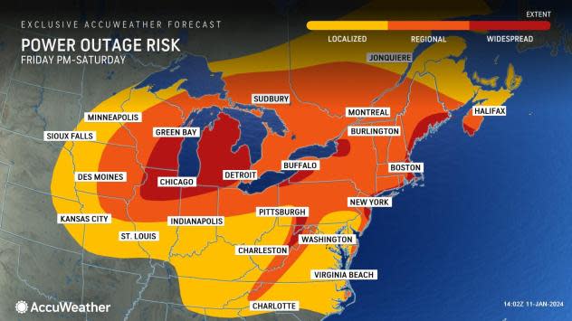
The new storm may have even stronger, farther-reaching and longer-lasting high winds compared to earlier in the week. This, combined with the fact that the soil has been so wet for so long, means that tree and property damage and the scope of power outages may be more widespread and severe this time around.
 |
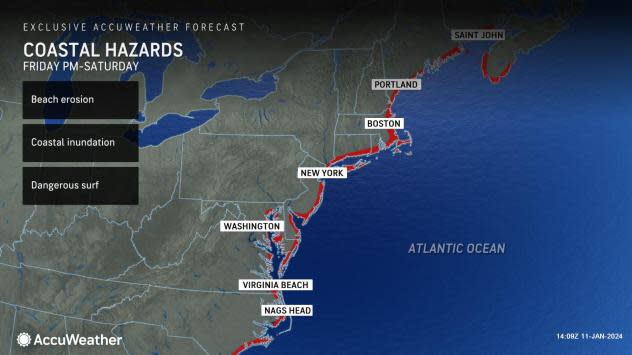
Some areas in the Appalachians and along the Eastern Seaboard will be hit with high winds from two directions.
The first round will have brief but powerful south and southeast winds. These winds will tend to push ocean water onto the barrier islands and up into the bays, where moderate coastal flooding can occur from the Carolinas to Maine.
 |
The second round of high winds will kick in fast but may be much longer-duration blusters from the west and northwest. Winds hitting the topsy-turvy trees from different directions in short order could take a toll.
Wind gusts of 40-60 mph from the storm will reach nearly every state from the Mississippi River to the Atlantic and Gulf coasts. Localized stronger gusts ranging from 60-80 mph are likely in the Appalachians and along the mid-Atlantic and New England coasts, where an AccuWeather Local StormMax™ gust of 90 mph is possible.
 |
There is the potential for millions of people to be without power in the eastern half of the nation due to the size and strength of the new storm. In heavily wooded areas, power outages could be lengthy due to the size of debris. This could put some people at risk as temperatures plunge in the wake of the new storm, due to the arrival of Arctic air for the first time this winter.
Forecasters recommend that people make sure that they have flashlights and batteries on hand. Generators should be fueled and tested. Experts advise always using generators outdoors, away from windows, to reduce the risk of fumes getting inside.
Want next-level safety, ad-free? Unlock advanced, hyperlocal severe weather alerts when you subscribe to Premium+ on the AccuWeather app. AccuWeather Alerts™ are prompted by our expert meteorologists who monitor and analyze dangerous weather risks 24/7 to keep you and your family safer.
