
 Yahoo News
 Weather map shows three areas where temperatures are set to soar
Three areas of the country are set to see temperatures soar with a blast of hot weather next week, despite the summer being a letdown with regular showers and brief moments of warm conditions. It is likely to continue to be wet and windy in parts of the north and west of the UK.
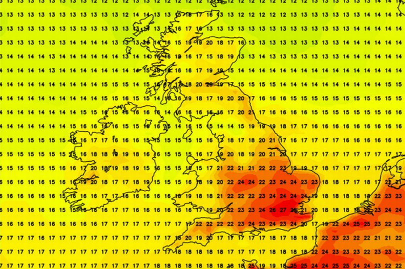
Weather maps from Netweather for Friday show the central part of England has temperatures of 8C below the average as the mercury drops to single figures. But charts for next week show improvements where temperatures could reach 27C on Thursday, July 11 for six hours in the southeast of England.
The Mirror reports that the map turns red in the south with temperatures mainly in the low to mid 20Cs, but isn't so promising for the northern areas, where it could remain as low as 11C in Scotland.
Read more: Godiva Festival 2024 lineup and set times for Richard Ashcroft, Paloma Faith and Beverley Knight
The chart predicts that it could feel like 28C in London which is the hottest area, but also shows red on the map for eastern, southeast, and western England.
Met Office forecaster Alex Burkill said: "So far this summer it has been a little disappointing perhaps and if you are hoping for something a little warmer we do have some good news coming up, if you are hoping for something more settled that may not be the case.
"Currently we have an active jet steam running across the UK it is running at 185mph which is pretty strong, especially for the time of year. That is going to be driving various weather systems as we go through the rest of the week and with that we do have some cooler air around which is why temperatures are several degrees below average for the time of year."
He also added it is likely to turn "quite a bit warmer" during next week with the possibility of a Scandinavian high: "When I say temperatures are rising they are only really rising to around average for the time of year nonetheless temperatures in July are fairly high so it is going to feel warm and even hot at times in the sunshine."
The Met Office forecast states that mid-July is likely to be unsettled with showers moving in while temperatures might be warm for a brief spell in the South East, otherwise they are likely to be below average.
“Confidence in the weather patterns at the beginning of this period is unusually low, with an erratic transition from cool, bright but showery weather over the previous weekend to something more unsettled, particularly in the south and west, likely to be underway,” states the national agency of the period July 9 to 18.
“Overall the period is expected to be predominantly unsettled; successive areas of cloud and rain moving in from the Atlantic and shorter settled interludes in-between. The bulk of the rainfall is likely to be across western and possibly southern parts, with far northwest and eastern areas more generally likely remaining drier. Temperatures are likely to come up to around average at first, with a chance of brief warm spells in the southeast, but overall temperatures will probably end up slightly cooler than average given the mainly unsettled outlook.”
Before that this weekend it is likely to see further rain. "The weather will remain unsettled and rather cool across the weekend, although there is some sunshine on offer, and when in it, temperatures will feel rather pleasant," said the Met Office.
"Early rain over east/southeast England on Saturday should soon clear, leading into a weekend of sunshine and showers, some of which could be heavy with a risk of hail or thunder. Some more persistent rain is possible at times in northern Scotland, while southwest Britain is likely to remain the driest overall. Most areas will feel breezy, with strong winds possible in the far southeast of England at first."
For Coventry, today will be some dry and brighter weather for most of the day, with a maximum temperature of 19C. There will be outbreaks of rain returning this evening, turning heavy and persistent and times during the night, but lighter by the morning, with a minimum temperature of 10C.
Here is the Met Office outlook for Coventry over the next few days:
Saturday:
An unsettled start to the weekend with sunny spells and blustery showers. Some turning heavy and possibly thundery. Feeling cool. Maximum temperature 17 °C.
Outlook for Sunday to Tuesday:
Sunny spells and showers on Sunday though lighter winds. A chance of showers and longer spells of rain to start the new week, with some brighter interludes. Feeling cool.
Get daily headlines and breaking news emailed to you - it’s FREE

